Garmin 2620 Owners Manual - Page 14
Learning how to use the Map Viewing the Map for the First Time, Reference - screen
 |
UPC - 753759045449
View all Garmin 2620 manuals
Add to My Manuals
Save this manual to your list of manuals |
Page 14 highlights
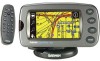
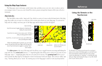
Reference Using the Map Page USING YOUR STREETPILOT INDOORS F Your StreetPilot unit cannot acquire satellites from inside a building. Thus, you may want to consider setting your unit to 'Use Indoor' status. To do this, press the MENU key on your unit. You will see a Menu page that includes a variety of setup options. Select the Use Indoors icon. Learning how to use the Map Page The Map page is your StreetPilot's main operating page. This page is the first image you see after the startup screens, and it's what you view as you navigate to a destination. Many features make up the Map page. Whether you're navigating a route or simply driving with your StreetPilot turned on, you will see a map that displays your current location as well as surrounding street detail. Additionally, depending on your current driving mode, tabs that appear on the Map page will provide such information as your current speed, your driving direction, and names of upcoming streets. You can look beyond your current position by "panning," or moving around the Map page. You can also zoom into locations to view greater street detail or you can zoom out to see what's ahead on your route. This section shows the many types of Map page views as well as how to use the features on the Map page. Practice using these features before navigating an actual route so that you can quickly understand what you are seeing on the Map page and thus limit time looking away from the road while driving. Viewing the Map Page for the First Time When you turn on your StreetPilot for the first time, you see a map image as well as a tab which shows that the StreetPilot is attempting to locate satellites. Once your StreetPilot locates the satellites, it establishes a "fix" on your location. It is then ready to navigate and you are ready to begin. When you turn on your StreetPilot, it searches for Once the satellites have been acquired, your satellites. 6 StreetPilot is ready to navigate. Touch the screen anywhere with your finger and move it around to view a variety of locations on your StreetPilot.
-
 1
1 -
2
-
3
-
4
-
5
-
6
-
7
-
8
-
 9
9 -
 10
10 -
 11
11 -
 12
12 -
 13
13 -
 14
14 -
 15
15 -
 16
16 -
 17
17 -
 18
18 -
 19
19 -
20
-
21
-
22
-
23
-
24
-
25
-
26
-
27
-
28
-
29
-
30
-
31
-
32
-
33
-
34
-
35
-
36
-
37
-
38
-
39
-
40
-
41
-
42
-
43
-
44
-
45
-
46
-
47
-
48
-
49
-
50
-
51
-
52
-
53
-
54
-
55
-
56
-
57
-
58
-
59
-
60
-
61
-
62
-
63
-
64
-
65
-
66
-
67
-
68
-
69
-
70
-
71
-
72
-
73
-
74
-
75
-
76
-
77
-
78
-
79
-
80
-
81
-
82
-
83
-
84
-
85
-
86
-
87
-
88
-
89
-
90
-
91
-
92
-
93
 |
 |
