Garmin ECHOMAP UHD 72sv Owners Manual - Page 33
Autopilot Screen
 |
View all Garmin ECHOMAP UHD 72sv manuals
Add to My Manuals
Save this manual to your list of manuals |
Page 33 highlights
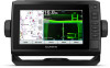
This applies to Panoptix transducers in the LiveVü Down, RealVü 3D Down, and RealVü 3D Historical sonar views. Calibrate Compass: Calibrates the internal compass in the Panoptix transducer (Transducer Installation Settings, page 25). This applies to Panoptix transducers with an internal compass, such as the PS21-TR transducer. Orientation: Controls if the transducer is in down or forward installation mode. The Auto setting uses the AHRS sensor to determine the orientation. This applies to PS22 and LiveScope transducers. Focus: Adjusts the sonar view to compensate for the speed of sound in water. The Auto setting uses the temperature of the water to calculate the speed of sound. This applies to LiveScope transducers. Restore Sonar Defaults: Restores the sonar settings to the factory default values. Setting the Bow Offset For forward view Panoptix transducers, you can enter a bow offset to compensate the forward distance readings for the transducer installation location. This allows you to view the forward distance from the bow instead of the transducer installation location. This feature applies to Panoptix transducers in the FrontVü, LiveVü Forward, and RealVü 3D Forward sonar views. 1 Measure the horizontal distance from the transducer to the bow. Learn to operate the autopilot on calm and hazard-free open water. Use caution when operating the autopilot near hazards in the water, such as docks, pilings, and other boats. NOTE: This feature is only available on models with NMEA 2000 network capabilities. The autopilot system continuously adjusts the steering of your boat to maintain a constant heading (heading hold). The system also allows manual steering and several modes of automaticsteering functions and patterns. When the compatible chartplotter is connected to a compatible Garmin autopilot system, you can engage and control the autopilot from the chartplotter. For information about compatible Garmin autopilot systems, go to garmin.com. Autopilot Screen Actual heading Intended heading (heading the autopilot is steering toward) Actual heading (when in standby mode) Intended heading (when engaged) Rudder position indicator (This functionality is available only when a rudder sensor is connected.) 2 From an applicable sonar view, select MENU > Sonar Setup > Installation > Bow Offset. 3 Enter the distance measured, and select Done. On the applicable sonar view, the forward range shifts by the distance you entered. Autopilot WARNING You can use the autopilot feature only at a station installed next to a helm, throttle, and helm control device. You are responsible for the safe and prudent operation of your vessel. The autopilot is a tool that enhances your capability to operate your boat. It does not relieve you of the responsibility of safely operating your boat. Avoid navigational hazards and never leave the helm unattended. Always be prepared to promptly regain manual control of your boat. Adjusting the Step Steering Increment 1 From the Autopilot screen, select MENU > Autopilot Setup > Step Turn Size. 2 Select an increment. Setting the Power Saver You can adjust the level of rudder activity. 1 From the autopilot screen, select MENU > Autopilot Setup > Power Mode Setup > Power Saver. 2 Select a percentage. Selecting a higher percentage reduces rudder activity and heading performance. The higher the percentage, the more the course deviates before the autopilot corrects it. TIP: In choppy conditions at low speeds, increasing the Power Saver percentage reduces rudder activity. Selecting the Preferred Heading Source NOTICE For best results, use the autopilot CCU internal compass for the heading source. Using a third-party GPS compass can cause the data to be delivered erratically and may result in excessive delays. The autopilot needs timely information, and therefore cannot often use third-party GPS compass data for GPS location or speed. If a third-party GPS compass is used, the autopilot will likely report loss of navigation data and speed source periodically. If you have more than one heading source on the network, you can select a your preferred source. The source could be a compatible GPS compass or a magnetic heading sensor. Autopilot 27
-
 1
1 -
2
-
3
-
4
-
5
-
6
-
7
-
8
-
9
-
10
-
11
-
12
-
13
-
14
-
15
-
16
-
17
-
18
-
19
-
20
-
21
-
22
-
23
-
24
-
25
-
26
-
27
-
 28
28 -
 29
29 -
 30
30 -
 31
31 -
 32
32 -
 33
33 -
 34
34 -
 35
35 -
 36
36 -
 37
37 -
 38
38 -
39
-
40
-
41
-
42
-
43
-
44
-
45
-
46
-
47
-
48
-
49
-
50
-
51
-
52
 |
 |
