Garmin GNS 430W Quick Reference Guide - Page 13
Navcom Terrain - series installation
 |
View all Garmin GNS 430W manuals
Add to My Manuals
Save this manual to your list of manuals |
Page 13 highlights
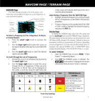
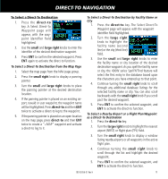
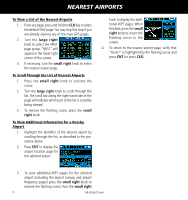
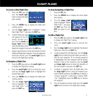
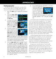
NAVCOM PAGE / TERRAIN PAGE NAVCOM Page The NAVCOM page provides a list of the airport com- munication and navigation frequencies at your departure, en route and arrival airports. Frequency Category Usage Restriction Information Departure, En Route or Arrival Airport Assigned Frequency Scroll Bar To Select a Frequency List for a Departure, En Route, or Arrival Airport 1. Press the small right knob to activate the cursor. 2. Turn the large right knob to place the cursor on the airport identifier field (top line on the NAVCOM page). 3. Turn the small right knob to select the desired airport and press ENT. To Scroll Through the List of Frequencies 1. Activate the cursor, if not already active, by pressing the small right knob. 2. Turn the large right knob to move the cursor through the list of frequencies. If there are more frequencies in the list than can be displayed on the screen, a scroll bar along the right-hand side of the screen will indicate which part of the list is currently being displayed. Auto-Tuning a Frequency from the NAVCOM Page 1. Highlight the desired frequency by scrolling through the list of frequencies, as described in the previous procedure. 2. To place a frequency in the standby field of the COM or VLOC window, highlight the desired frequency and press the ENT key. Terrain Page To display the TERRAIN Page, select the NAV group and turn the small right knob until the TERRAIN Page is displayed. The page displays terrain information, aircraft ground track, and GPS-derived MSL altitude (GSL altitude). Altitude is shown in increments of 20 feet or in increments of 10 meters, depending on unit configuration. For units with installed in helicopters or equipped with optional HTAWS, refer to 400W/500W Series Garmin Optional Displays, P/N 190-00356-30 Rev G, or later. To inhibit TERRAIN: 1. Select the TERRAIN Page and press MENU. "Inhibit Terrain?" is selected by default. 2. Press ENT. The TERRAIN system is inhibited. The annunciation is displayed in the terrain annunciator field whenever terrain is inhibited. Obstacle Symbol Unlighted Obstacle Lighted Obstacle < 1000' AGL > 1000' AGL < 1000' AGL > 1000' AGL Color Red Yellow TERRAIN/Obstacle Location Terrain/Obstacle above or within 100 ft below current aircraft altitude Terrain/Obstacle between 100 ft and 1000 ft below the aircraft altitude Terrain Color Symbology 190-00356-01 Rev H 11
-
 1
1 -
2
-
3
-
4
-
5
-
6
-
7
-
 8
8 -
 9
9 -
 10
10 -
 11
11 -
 12
12 -
 13
13 -
 14
14 -
 15
15 -
 16
16 -
 17
17 -
 18
18 -
19
-
20
-
21
-
22
-
23
-
24
 |
 |
