Garmin GPSMAP 6012 Owner's Manual - Page 127
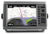
GPSMAP, 7000 Series Owner's Manual, Fish Eye 3D
 |
View all Garmin GPSMAP 6012 manuals
Add to My Manuals
Save this manual to your list of manuals |
Page 127 highlights
Index A active tracks clearing 41 retracing 40 saving 40 add turn 36 aerial photos 21, 26 AIS radar 79 targeting 15, 113 threats 18, 79 alarms anchor drag 67 arrival 67 clock 68 collision 15, 18, 77, 79 deep water 105 fish 106 GPS accuracy 68 navigation 67 off course 67 shallow water 105 sonar 105 system 68 total fuel onboard 68 unit voltage 68 water temperature 105 anchor drag alarm 67 animated currents, tides 10, 27 antenna rotation speed 94 size 95 apparent wind 64, 93 arrival alarm 67 Auto Guidance BlueChart g2 Vision 27 line 59 navigation 7 shoreline distance 60 autopilot 41 B backlight 1, 3 basemap version 4 BlueChart g2 Vision aerial photos 13 chart borders 13 chart symbols 7 data cards 21 Fish Eye 3D 24 Mariner's Eye 3D 22 POIs 27 C celestial information 48 charts borders 13 details 13 fishing 21 navigation 6 symbols 7, 13, 98 clock alarm 68 clutter cross talk 85 default settings 86 FTC 85, 89, 90 radar type 85 rain 85, 89, 90 sea 85, 88 collision alarm 15, 18, 77, 79 color mode 3 color scheme radar 93 sonar 104 combinations customizing 28 data fields 29 focus screen 30 functions 28 instrumentation data 30 layout 28 selecting 28 combinations data field adding 29 editing 30 removing 29 compass roses 14 compass tape data bar 65, 93 connectors 2 coordinate systems 61 courses 33, 35 cross talk 85, 91 cruising data bar 63, 91 Cruising mode 73 current stations indicators 10, 27 nearby 47 reports 47 D dangerous depth 12 data backup 71 copying 69 data bars compass tape 65, 93 cruising 63, 91 fishing 64, 92 fuel 64, 92 Index navigation 63, 92 radar 91 sailing 64, 92 data cards 4 BlueChart g2 Vision 21 data management 69 daylight saving time 62 deep water alarm 105 depth shading 13 destinations 32 navigating to 43 navigation chart 32 selecting 32 Where To? 32 digital selective calling channels 113 contacts 109 turning on 108 distress calls 109, 110 DSC 108 Dual Range mode 75 E EBL measuring 81 showing 80 engine gauges 51 combinations screen 30 configuring 51 cycling screens 51 status alarms 52 event log 95 F factory settings 3, 116 fish alarm 106 Fish Eye 3D data bars 62 object information 9 sonar cone 24 suspended targets 24 tracks 24 fishing chart AIS 18 currents 10 data bars 62 heading line 12 inset map 8 map orientation 11 MARPA 18 navaids 13, 25 navigation 7 object information 9 panning 8 Radar Overlay 21, 84 roses 14 GPSMAP® 6000/7000 Series Owner's Manual 121
-
 1
1 -
2
-
3
-
4
-
5
-
6
-
7
-
8
-
9
-
10
-
11
-
12
-
13
-
14
-
15
-
16
-
17
-
18
-
19
-
20
-
21
-
22
-
23
-
24
-
25
-
26
-
27
-
28
-
29
-
30
-
31
-
32
-
33
-
34
-
35
-
36
-
37
-
38
-
39
-
40
-
41
-
42
-
43
-
44
-
45
-
46
-
47
-
48
-
49
-
50
-
51
-
52
-
53
-
54
-
55
-
56
-
57
-
58
-
59
-
60
-
61
-
62
-
63
-
64
-
65
-
66
-
67
-
68
-
69
-
70
-
71
-
72
-
73
-
74
-
75
-
76
-
77
-
78
-
79
-
80
-
81
-
82
-
83
-
84
-
85
-
86
-
87
-
88
-
89
-
90
-
91
-
92
-
93
-
94
-
95
-
96
-
97
-
98
-
99
-
100
-
101
-
102
-
103
-
104
-
105
-
106
-
107
-
108
-
109
-
110
-
111
-
112
-
113
-
114
-
115
-
116
-
117
-
118
-
119
-
120
-
121
-
 122
122 -
 123
123 -
 124
124 -
 125
125 -
 126
126 -
 127
127 -
 128
128 -
 129
129 -
 130
130 -
 131
131 -
 132
132
 |
 |
