Garmin GPSMAP 76C Owner's Manual - Page 40
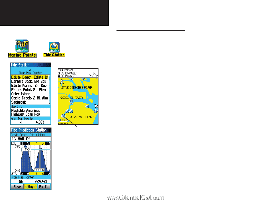
Searching for a Marine Point, To find a Tide Prediction Station
 |
UPC - 753759045098
View all Garmin GPSMAP 76C manuals
Add to My Manuals
Save this manual to your list of manuals |
Page 40 highlights
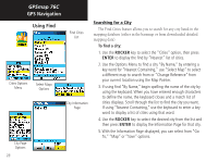
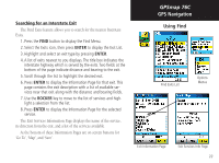
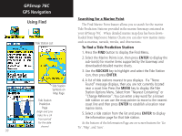
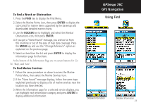
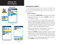
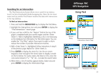
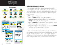
GPSmap 76C GPS Navigation Using Find Tide Station List Searching for a Marine Point The Find Marine Point feature allows you to search for the marine Tide Prediction Stations provided in the marine basemap contained in your GPSmap 76C . When detailed marine map data has been downloaded from MapSource Marine Charts you can also view marine items such as marinas, navaids, wrecks, and obstructions. To find a Tide Prediction Station 1. Press the FIND button to display the Find Menu. 2. Select the Marine Points icon, then press ENTER to display the sub-icon(s) for marine items supported by the basemap and downloaded detailed marine charts. 3. Use the ROCKER key to highlight and select the Tide Station icon, then press ENTER. 4. A list of tide stations nearest to you displays. If a "None Tide Station Symbols on Map Page Found" message displays, then you are not currently located near a coast line. Press the MENU key to display the Tide Station Options Menu. Select from "Nearest Containing" or "Change Reference". You can enter a key word for a known Tide Station tide station or can use the map pointer to move to the nearest Prediction coast line and then press ENTER to establish a location near Page marine items. (High and Low tides for a 24 hour period 5. Select a tide station from the list and press ENTER to display the information page for that tide station. for the date At the bottom of the Information Page are on-screen buttons for 'Go shown) To', 'Map', and 'Save'. 30
-
 1
1 -
2
-
3
-
4
-
5
-
6
-
7
-
8
-
9
-
10
-
11
-
12
-
13
-
14
-
15
-
16
-
17
-
18
-
19
-
20
-
21
-
22
-
23
-
24
-
25
-
26
-
27
-
28
-
29
-
30
-
31
-
32
-
33
-
34
-
 35
35 -
 36
36 -
 37
37 -
 38
38 -
 39
39 -
 40
40 -
 41
41 -
 42
42 -
 43
43 -
 44
44 -
 45
45 -
46
-
47
-
48
-
49
-
50
-
51
-
52
-
53
-
54
-
55
-
56
-
57
-
58
-
59
-
60
-
61
-
62
-
63
-
64
-
65
-
66
-
67
-
68
-
69
-
70
-
71
-
72
-
73
-
74
-
75
-
76
-
77
-
78
-
79
-
80
-
81
-
82
-
83
-
84
-
85
-
86
-
87
-
88
-
89
-
90
-
91
-
92
-
93
-
94
-
95
-
96
 |
 |