Lowrance HDS-9 Gen2 Touch Operation Manual - Page 34
Waypoints, routes & trails
 |
View all Lowrance HDS-9 Gen2 Touch manuals
Add to My Manuals
Save this manual to your list of manuals |
Page 34 highlights
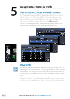
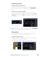
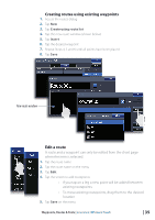
5 Waypoints, routes & trails The waypoints, route and trails screens The Waypoints, Routes and Trails dialogs give access to advanced edit functions and settings for all these items available on your system. Waypoint, route and trail screens are accessed from the homescreen or by pressing and holding the Waypoint key. The edit and settings options are accessed from the menu or by pressing and holding the unit's dedicated waypoint key. Waypoints A waypoint is a user generated mark positioned on a chart, on a radar image or on a sonar image. Each waypoint has an exact position with latitude and longitude coordinates. A waypoint positioned on a sonar image, will in addition to position information have a depth value. A waypoint is used to mark a position you later may want to return to. Two or more waypoints can also be combined to create a route. 32 | Waypoints, Routes & Trails | Lowrance HDS Gen2 Touch
-
 1
1 -
2
-
3
-
4
-
5
-
6
-
7
-
8
-
9
-
10
-
11
-
12
-
13
-
14
-
15
-
16
-
17
-
18
-
19
-
20
-
21
-
22
-
23
-
24
-
25
-
26
-
27
-
28
-
 29
29 -
 30
30 -
 31
31 -
 32
32 -
 33
33 -
 34
34 -
 35
35 -
 36
36 -
 37
37 -
 38
38 -
 39
39 -
40
-
41
-
42
-
43
-
44
-
45
-
46
-
47
-
48
-
49
-
50
-
51
-
52
-
53
-
54
-
55
-
56
-
57
-
58
-
59
-
60
-
61
-
62
-
63
-
64
-
65
-
66
-
67
-
68
-
69
-
70
-
71
-
72
-
73
-
74
-
75
-
76
-
77
-
78
-
79
-
80
-
81
-
82
-
83
-
84
-
85
-
86
-
87
-
88
-
89
-
90
-
91
-
92
-
93
-
94
-
95
-
96
-
97
-
98
-
99
-
100
-
101
-
102
-
103
-
104
-
105
-
106
-
107
-
108
-
109
-
110
-
111
-
112
-
113
-
114
-
115
-
116
-
117
-
118
-
119
-
120
-
121
-
122
-
123
-
124
-
125
-
126
-
127
-
128
-
129
-
130
-
131
-
132
-
133
-
134
-
135
-
136
-
137
 |
 |
