Lowrance HDS-9 Gen2 Touch Operation Manual - Page 38
Trails
 |
View all Lowrance HDS-9 Gen2 Touch manuals
Add to My Manuals
Save this manual to your list of manuals |
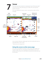
Page 38 highlights
Trails A trail is a graphical presentation of the historical path of the vessel, allowing you to retrace where you have traveled. A trail can be converted to a route in the Trail screen, as described later in this section. From the factory, the system is set to automatically draw a trail. The system will continue to record the trail until the trail length reaches the maximum trail point setting, and will then automatically begin overwriting the oldest trail points. The automatic trail function can be turned off from the Trail screen described later in this section. Creating a new trail Tap New on the Trails dialog and tap Save to create a new trail. Trail settings are defined on the Trail Settings dialog described below. Trail settings The trail is made up of a series of trail points connected by line segments. You can select to record trail points based on time, distance or by letting the unit position a point automatically when a course change is registered. ¼¼ Note: The Trails option must also be turned ON in the chart settings to be visible. 36 | Waypoints, Routes & Trails | Lowrance HDS Gen2 Touch
-
 1
1 -
2
-
3
-
4
-
5
-
6
-
7
-
8
-
9
-
10
-
11
-
12
-
13
-
14
-
15
-
16
-
17
-
18
-
19
-
20
-
21
-
22
-
23
-
24
-
25
-
26
-
27
-
28
-
29
-
30
-
31
-
32
-
 33
33 -
 34
34 -
 35
35 -
 36
36 -
 37
37 -
 38
38 -
 39
39 -
 40
40 -
 41
41 -
 42
42 -
 43
43 -
44
-
45
-
46
-
47
-
48
-
49
-
50
-
51
-
52
-
53
-
54
-
55
-
56
-
57
-
58
-
59
-
60
-
61
-
62
-
63
-
64
-
65
-
66
-
67
-
68
-
69
-
70
-
71
-
72
-
73
-
74
-
75
-
76
-
77
-
78
-
79
-
80
-
81
-
82
-
83
-
84
-
85
-
86
-
87
-
88
-
89
-
90
-
91
-
92
-
93
-
94
-
95
-
96
-
97
-
98
-
99
-
100
-
101
-
102
-
103
-
104
-
105
-
106
-
107
-
108
-
109
-
110
-
111
-
112
-
113
-
114
-
115
-
116
-
117
-
118
-
119
-
120
-
121
-
122
-
123
-
124
-
125
-
126
-
127
-
128
-
129
-
130
-
131
-
132
-
133
-
134
-
135
-
136
-
137
 |
 |
