Meade LX70 R5 5 inch Instruction Manual - Page 19
APPENDIX A, Celestial Coordinates
 |
View all Meade LX70 R5 5 inch manuals
Add to My Manuals
Save this manual to your list of manuals |
Page 19 highlights
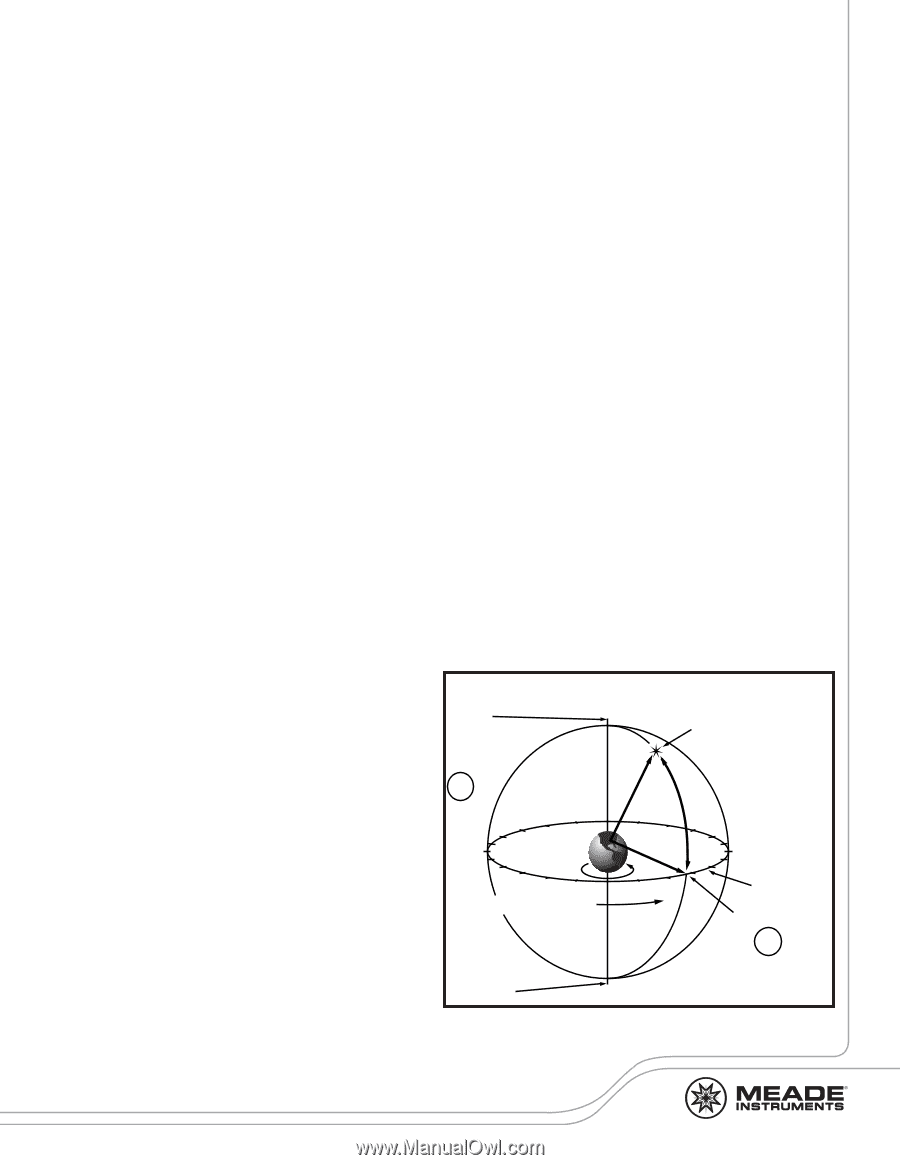
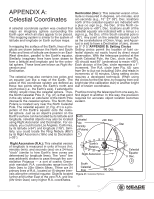
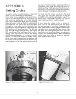
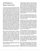
APPENDIX A: Declination (Dec.): This celestial version of lat- Celestial Coordinates itude is measured in degrees, arc-minutes, and arc-seconds (e.g., 15° 27' 33"). Dec. locations north of the celestial equator are indicated with a plus (+) sign (e.g., the Dec. of the North ce- A celestial coordinate system was created that lestial pole is +90°). Dec. locations south of the maps an imaginary sphere surrounding the celestial equator are indicated with a minus (-) Earth upon which all stars appear to be placed. sign (e.g., the Dec. of the South celestial pole is This mapping system is similar to the system of -90°). Any point on the celestial equator (such latitude and longitude on Earth surface maps. as the constellations of Orion, Virgo, and Aquar- ius) is said to have a Declination of zero, shown In mapping the surface of the Earth, lines of lon- as 0° 0' 0."APPENDIX B: Setting Circles gitude are drawn between the North and South Setting circles permit the location of faint ce- Poles and lines of latitude are drawn in an East- lestial objects not easily found by direct visual West direction, parallel to the Earth's equator. observation. With the telescope pointed at the Similarly, imaginary lines have been drawn to North Celestial Pole, the Dec. circle (see Fig. form a latitude and longitude grid for the celes- 43) should read 90° (understood to mean +90°). tial sphere. These lines are known as Right As- Each division of the Dec. circle represents a 1° cension and increment. The R.A. circle (see Fig. 42) runs Declination. from 0hr to (but not including) 24hr, and reads in increments of 10 minutes. Using setting circles The celestial map also contains two poles and requires a developed technique. When using an equator just like a map of the Earth. The the circles for the first time, try hopping from one poles of this coordinate system are defined as bright star (the calibration star) to another bright those two points where the Earth's north and star of known coordinates. south poles (i.e., the Earth's axis), if extended to infinity, would cross the celestial sphere. Thus, Practice moving the telescope from one easy-to- the North Celestial Pole (1, Fig. 41) is that point find object to another. In this way, the precision in the sky where an extension of the North Pole required for accurate object location becomes intersects the celestial sphere. The North Star, evident. Polaris is located very near the North Celestial Pole. The celestial equator (2, Fig. 41) is a pro- jection of the Earth's equator onto the celes- tial sphere. Just as an object's position on the Earth's surface can be located by its latitude and North longitude, celestial objects may also be located using Right Ascension and Declination. For example, you could locate Los Angeles, California, by its latitude (+34°) and longitude (118°). Similarly, you could locate the Ring Nebula (M57) Celestial Pole (Vicinity of Polaris) +90 Dec. Star Declination by its Right Ascension (18hr) and its Declination 1 (+33°). Right Ascension (R.A.): This celestial version of longitude is measured in units of hours (hr), minutes (min), and seconds (sec) on a 24-hour "clock" (similar to how Earth's time zones are determined by longitude lines). The "zero" line was arbitrarily chosen to pass through the constellation Pegasus - a sort of cosmic Greenwich meridian. R.A. coordinates range from 0hr 0min 0sec to 23hr 59min 59sec. There are 24 primary lines of R.A., located at 15-degree inter- 17 18 16 15 14 13 Earth's 12 11 10 19 Rotation 20 21 22 23 012 Right Ascension South Celestial Pole -90 Dec. 98 7 6 5 3 4 Celestial Equator 0 Dec. 2 vals along the celestial equator. Objects located Figure 41: Celestial Sphere further and further East of the zero R.A. grid line (0hr 0min 0sec) carry higher R.A. coordinates. 19
-
 1
1 -
2
-
3
-
4
-
5
-
6
-
7
-
8
-
9
-
10
-
11
-
12
-
13
-
 14
14 -
 15
15 -
 16
16 -
 17
17 -
 18
18 -
 19
19 -
 20
20 -
 21
21 -
 22
22 -
 23
23 -
 24
24 -
25
-
26
-
27
-
28
 |
 |