Motorola DROID X Verizon User Guide - Page 44
Select map mode, Press Menu
 |
UPC - 723755811829
View all Motorola DROID X manuals
Add to My Manuals
Save this manual to your list of manuals |
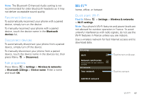
Page 44 highlights
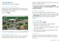
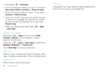
1 Press Menu > Directions. 2 Enter a starting point address or touch and select My current location, Contacts, or Points on map. 3 Enter an end point address or touch and select Contacts or Points on map. 4 Select your mode of transport (car, public transport or walk), then touch Go. Your directions are shown as a list. To view your directions on a map, touch Show on map. 5 When you have finished, press Menu > Clear map. > More Select map mode Press Menu > Layers to select from Traffic, Satellite, Latitude or recent searches, viewed positions or directions. Press Menu > Layers > More layers to select from My Maps, Wikipedia, or Transit Lines. Touch Clear Map to clear your selections. Map view Shows a map, complete with names of streets, rivers, lakes, mountains, and borders. This is the default view. Satellite view Shows map on top of aerial photo. 42 Google Maps™ Traffic view If available in your area, real-time traffic conditions are shown on the roads as color-coded lines.
-
 1
1 -
2
-
3
-
4
-
5
-
6
-
7
-
8
-
9
-
10
-
11
-
12
-
13
-
14
-
15
-
16
-
17
-
18
-
19
-
20
-
21
-
22
-
23
-
24
-
25
-
26
-
27
-
28
-
29
-
30
-
31
-
32
-
33
-
34
-
35
-
36
-
37
-
38
-
 39
39 -
 40
40 -
 41
41 -
 42
42 -
 43
43 -
 44
44 -
 45
45 -
 46
46 -
 47
47 -
 48
48 -
 49
49 -
50
-
51
-
52
-
53
-
54
-
55
-
56
-
57
-
58
-
59
-
60
-
61
-
62
-
63
-
64
-
65
-
66
-
67
-
68
-
69
-
70
 |
 |
