Nikon COOLPIX S9700 Product Manual - Page 248
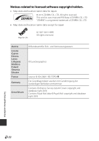
Technical Notes and Index, Israel, Jordan, Mozambique, Nicaragua, Réunion, Ecuador, Guadeloupe
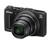 |
View all Nikon COOLPIX S9700 manuals
Add to My Manuals
Save this manual to your list of manuals |
Page 248 highlights
Israel © Survey of Israel data source Jordan © Royal Jordanian Geographic Centre. Mozambique Certain Data for Mozambique provided by Cenacarta © 2013 by Cenacarta Nicaragua The Pacific Ocean and Caribbean Sea maritime borders have not been entirely defined. Northern land border defined by the natural course of the Coco River (also known as Segovia River or Wangki River) corresponds to the source of information available at the moment of its representation. Réunion Ecuador ® source: © IGN 2009 - BD TOPO INSTITUTO GEOGRAFICO MILITAR DEL ECUADRO AUTORIZACION N° IGM-2011-01- PCO-01 DEL 25 DE ENERO DE 2011 Guadeloupe Guatemala ® source: © IGN 2009 - BD TOPO Aprobado por el INSTITUTO GEOGRAFICO NACIONAL Resolución del IGN N° 186-2011 French Guiana Martinique ® source: © IGN 2009 - BD TOPO ® source: © IGN 2009 - BD TOPO Technical Notes and Index F24
-
 1
1 -
2
-
3
-
4
-
5
-
6
-
7
-
8
-
9
-
10
-
11
-
12
-
13
-
14
-
15
-
16
-
17
-
18
-
19
-
20
-
21
-
22
-
23
-
24
-
25
-
26
-
27
-
28
-
29
-
30
-
31
-
32
-
33
-
34
-
35
-
36
-
37
-
38
-
39
-
40
-
41
-
42
-
43
-
44
-
45
-
46
-
47
-
48
-
49
-
50
-
51
-
52
-
53
-
54
-
55
-
56
-
57
-
58
-
59
-
60
-
61
-
62
-
63
-
64
-
65
-
66
-
67
-
68
-
69
-
70
-
71
-
72
-
73
-
74
-
75
-
76
-
77
-
78
-
79
-
80
-
81
-
82
-
83
-
84
-
85
-
86
-
87
-
88
-
89
-
90
-
91
-
92
-
93
-
94
-
95
-
96
-
97
-
98
-
99
-
100
-
101
-
102
-
103
-
104
-
105
-
106
-
107
-
108
-
109
-
110
-
111
-
112
-
113
-
114
-
115
-
116
-
117
-
118
-
119
-
120
-
121
-
122
-
123
-
124
-
125
-
126
-
127
-
128
-
129
-
130
-
131
-
132
-
133
-
134
-
135
-
136
-
137
-
138
-
139
-
140
-
141
-
142
-
143
-
144
-
145
-
146
-
147
-
148
-
149
-
150
-
151
-
152
-
153
-
154
-
155
-
156
-
157
-
158
-
159
-
160
-
161
-
162
-
163
-
164
-
165
-
166
-
167
-
168
-
169
-
170
-
171
-
172
-
173
-
174
-
175
-
176
-
177
-
178
-
179
-
180
-
181
-
182
-
183
-
184
-
185
-
186
-
187
-
188
-
189
-
190
-
191
-
192
-
193
-
194
-
195
-
196
-
197
-
198
-
199
-
200
-
201
-
202
-
203
-
204
-
205
-
206
-
207
-
208
-
209
-
210
-
211
-
212
-
213
-
214
-
215
-
216
-
217
-
218
-
219
-
220
-
221
-
222
-
223
-
224
-
225
-
226
-
227
-
228
-
229
-
230
-
231
-
232
-
233
-
234
-
235
-
236
-
237
-
238
-
239
-
240
-
241
-
242
-
 243
243 -
 244
244 -
 245
245 -
 246
246 -
 247
247 -
 248
248 -
 249
249 -
 250
250 -
 251
251 -
 252
252 -
 253
253 -
254
-
255
-
256
-
257
-
258
-
259
-
260
-
261
-
262
 |
 |
