Pioneer AVIC-7000NEX Owner's Manual - Page 26
How to read the Map screen, Frequently shown route, events, How to use the map
 |
View all Pioneer AVIC-7000NEX manuals
Add to My Manuals
Save this manual to your list of manuals |
Page 26 highlights
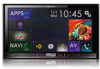
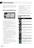
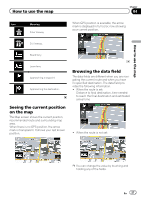
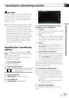
Chapter 04 How to use the map Most of the information provided by your navigation system can be seen on the map. You need to become familiar with how information appears on the map. How to read the Map screen 1 2 3 4 a 5 6 9 7 8 p Information with an asterisk (*) appears only when the route is set. p Depending on the conditions and settings, some items may not be displayed. p The AV information is displayed in the bottom of the Map screen. p You can decide whether you want to see the speed limit sign on the map all the time. If you exceed the speed limit, the sign color is changed. = For details, refer to "Warnings" settings on page 50. 1 Shows the number and name of the street to be used (or next guidance point).* 2 Shows the next guidance point (maneuver).* Both the type of the event (turn, traffic circle, exiting freeway, etc.) and its distance from the current position are displayed. A smaller icon shows the type of the second next maneuver if it is near the next maneuver. = For details, refer to Frequently shown route events on page 26. 3 Shows the distance to the next guidance point (maneuver).* 4 Shows the second maneuver arrow.* 5 Indicates the current location of your vehicle. The apex of the triangular mark indicates your orientation and the display moves automatically as you drive. 6 Displays the data field. Touching this field displays route information during navigation. = For details, refer to Browsing the data field on page 27. 7 Shows the name of the street (or city) that your vehicle is traveling on (or in). 8 Indicates the current route.* The route currently set is highlighted in color on the map. 9 Displays the Navigation menu screen. a Indicates the progress to the final destination.* Frequently shown route events Icon Meaning Turn left. Turn right. Turn back. Bear right. Turn sharp left. Keep left. Continue straight in the intersection. Go left on the traffic circle, 3rd exit (next maneuver). Enter traffic circle (second next maneuver). 26 En
-
 1
1 -
2
-
3
-
4
-
5
-
6
-
7
-
8
-
9
-
10
-
11
-
12
-
13
-
14
-
15
-
16
-
17
-
18
-
19
-
20
-
 21
21 -
 22
22 -
 23
23 -
 24
24 -
 25
25 -
 26
26 -
 27
27 -
 28
28 -
 29
29 -
 30
30 -
 31
31 -
32
-
33
-
34
-
35
-
36
-
37
-
38
-
39
-
40
-
41
-
42
-
43
-
44
-
45
-
46
-
47
-
48
-
49
-
50
-
51
-
52
-
53
-
54
-
55
-
56
-
57
-
58
-
59
-
60
-
61
-
62
-
63
-
64
-
65
-
66
-
67
-
68
-
69
-
70
-
71
-
72
-
73
-
74
-
75
-
76
-
77
-
78
-
79
-
80
-
81
-
82
-
83
-
84
-
85
-
86
-
87
-
88
-
89
-
90
-
91
-
92
-
93
-
94
-
95
-
96
-
97
-
98
-
99
-
100
-
101
-
102
-
103
-
104
-
105
-
106
-
107
-
108
-
109
-
110
-
111
-
112
-
113
-
114
-
115
-
116
-
117
-
118
-
119
-
120
-
121
-
122
-
123
-
124
-
125
-
126
-
127
-
128
-
129
-
130
-
131
-
132
-
133
-
134
-
135
-
136
-
137
-
138
-
139
-
140
-
141
-
142
-
143
-
144
-
145
-
146
-
147
-
148
-
149
-
150
-
151
-
152
-
153
-
154
-
155
-
156
-
157
-
158
-
159
-
160
-
161
-
162
-
163
-
164
-
165
-
166
-
167
-
168
-
169
-
170
-
171
-
172
-
173
-
174
-
175
-
176
-
177
-
178
-
179
-
180
-
181
-
182
-
183
-
184
-
185
-
186
-
187
-
188
-
189
-
190
-
191
-
192
-
193
-
194
-
195
-
196
-
197
-
198
-
199
-
200
-
201
-
202
-
203
-
204
-
205
-
206
-
207
-
208
-
209
-
210
-
211
-
212
-
213
-
214
-
215
-
216
-
217
-
218
-
219
-
220
-
221
-
222
-
223
-
224
-
225
-
226
-
227
-
228
 |
 |