Garmin GPS 48 Owner's Manual - Page 18
Satellite
 |
UPC - 753759007553
View all Garmin GPS 48 manuals
Add to My Manuals
Save this manual to your list of manuals |
Page 18 highlights
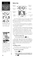
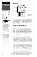
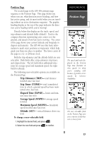
REFERENCE Satellite Page Satellite Page Status Field Battery Indicator Estimated Position Error Skyview Display Signal Strength Indicators The GPS 48 Satellite Page will help you determine which satellites are in view, and whether or not any satellites are being "shaded" or blocked from receiving satellite signals (See satellite 02 above). By periodically monitoring the signal strength bars at the bottom of the page and the north up sky view, you will be able to see how moving to another area with a clearer view of the sky will improve satellite reception and speed up signal acquisition. 14 The GPS 48's Satellite Page displays the status of various receiver functions. The status information will help you understand what the GPS 48 is doing at any given time, and will tell you whether or not the receiver has calculated a position fix. Sky View and Signal Strength Bars The sky view and signal strength bars give you an indication of what satellites are visible to the receiver, whether or not they are being used to calculate a position fix, and the signal quality. The satellite sky view shows a bird's-eye-view of the position of each available satellite relative to the unit's last known position. The outer circle represents the horizon (north up); the inner circle is 45º above the horizon; and the center point is directly overhead. You can use the sky view to help determine if any satellites are being blocked, and whether you have a current position fix (indicated by a '2D NAV' or '3D NAV' in the status field). You can also set the sky view to a track up configuration by changing the 'orientation' option on the Map Page. (See pg. 24 for setup instructions.) While the receiver is looking for satellites the satellite number will be highlighted in the sky view. When the receiver locates and begins satellite reception, the satellite number will no longer be highlighted and a hollow strength indicator will be displayed at the bottom of the page. After the receiver has gathered the satellite information and can use the satellite for navigation the strength indicator bar will become solid. As soon as the GPS 48 has gathered enough satellites to calculate a position the status field will indicate a 2D or 3D fix.
-
 1
1 -
2
-
3
-
4
-
5
-
6
-
7
-
8
-
9
-
10
-
11
-
12
-
 13
13 -
 14
14 -
 15
15 -
 16
16 -
 17
17 -
 18
18 -
 19
19 -
 20
20 -
 21
21 -
 22
22 -
 23
23 -
24
-
25
-
26
-
27
-
28
-
29
-
30
-
31
-
32
-
33
-
34
-
35
-
36
-
37
-
38
-
39
-
40
-
41
-
42
-
43
-
44
-
45
-
46
-
47
-
48
-
49
-
50
-
51
-
52
-
53
-
54
-
55
-
56
-
57
-
58
-
59
-
60
-
61
-
62
-
63
-
64
-
65
-
66
-
67
-
68
-
69
-
70
-
71
-
72
-
73
-
74
 |
 |
