Garmin GPS 48 Owner's Manual - Page 31
Navaid Setup
 |
UPC - 753759007553
View all Garmin GPS 48 manuals
Add to My Manuals
Save this manual to your list of manuals |
Page 31 highlights
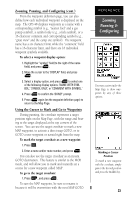
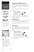
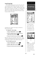
Navaid Setup Page The navaid setup page lets you select the zoom scale where navaids become visible on the map. The setup page is divided into two columns, range and zoom, with label setup at the bottom of the page. The 'RANGE' field represents the visible range of the navaid, the 'ZOOM' field is user-selectable and determines when the navaid becomes visible on the map. REFERENCE Navaid Setup Navaids become visible on the map at or below the selected zoom setting. To change the zoom setting: 1. Highlight 'NAVAID SETUP', and press E. 2. Select the 'ZOOM' field that corresponds with the navaid visible range, and press E. 3. Change to the desired zoom scale and press E. Below the range and zoom fields is label setup. Labels contain the navaid descriptions and can be set to display on the map at or below a user-selected zoom scale. To set the label zoom scale: 1. Highlight 'NAVAID SETUP', and press E 2. Highlight 'LABEL SETUP' and press E 3. Change to the desired zoom scale and press E. The Nautical Navaids can be configured to display at a user -selected zoom range by selecting 'NAVAID SETUP' on the map configuration menu. Labels contain information about the navaid. Labels can be activated by panning the map cursor to the navaid or by reaching the selected map zoom scale 27
-
 1
1 -
2
-
3
-
4
-
5
-
6
-
7
-
8
-
9
-
10
-
11
-
12
-
13
-
14
-
15
-
16
-
17
-
18
-
19
-
20
-
21
-
22
-
23
-
24
-
25
-
 26
26 -
 27
27 -
 28
28 -
 29
29 -
 30
30 -
 31
31 -
 32
32 -
 33
33 -
 34
34 -
 35
35 -
 36
36 -
37
-
38
-
39
-
40
-
41
-
42
-
43
-
44
-
45
-
46
-
47
-
48
-
49
-
50
-
51
-
52
-
53
-
54
-
55
-
56
-
57
-
58
-
59
-
60
-
61
-
62
-
63
-
64
-
65
-
66
-
67
-
68
-
69
-
70
-
71
-
72
-
73
-
74
 |
 |
