Garmin GPS 48 Owner's Manual - Page 35
Highway
 |
UPC - 753759007553
View all Garmin GPS 48 manuals
Add to My Manuals
Save this manual to your list of manuals |
Page 35 highlights
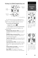
Using the Highway Page Bearing to Waypoint Track Over Ground Distance to Waypoint Speed Over Ground Destination Waypoint Graphic Highway CDI Scale User Selectable Field The GPS 48's Highway Page provides graphic steering guidance to a destination waypoint, with a greater emphasis on the straight-line desired course and the distance and direction you are off course. The bearing and distance to a waypoint - along with your current track and speed - are displayed at the top of the screen. As you head toward your destination, the middle of the screen provides visual guidance to your waypoint on a moving graphic "highway." Your present position is represented by the diamond in the center of the course deviation scale. The line down the middle of the highway represents your desired track. As you navigate toward a waypoint, the highway will actually move-indicating the direction you're off course-relative to the position diamond on the CDI scale. When the highway is pointing straight up the screen, the waypoint is directly ahead. If the destination waypoint is to the left, the top of the highway will lead to the left, and vice versa. To stay on course, simply steer in the direction the highway leads (left or right) until the highway leads straight up the page. If you do get off the desired course by more than 1/5th of the selected CDI range, the exact distance you are off course will be displayed where the CDI scale setting normally appears. If you get too far off course (the highway has disappeared), a message box will appear to indicate what course to steer to get back on course. (For information on how to set this scale, see pg. 44.) As you approach a waypoint, a horizontal "finish line" will move toward the bottom of the highway. When the finish line reaches the CDI scale, you've arrived at your destination. REFERENCE Highway Page In this example, the Highway Page indicates that you are off course to the right. Steer left to get back on course. Notice the highway always shows the direction to turn. If the highway leads straight up the page, you should continue in your current direction. If you get too far off course, a message box will appear to indicate what course to steer to get back on course most efficiently. 31
-
 1
1 -
2
-
3
-
4
-
5
-
6
-
7
-
8
-
9
-
10
-
11
-
12
-
13
-
14
-
15
-
16
-
17
-
18
-
19
-
20
-
21
-
22
-
23
-
24
-
25
-
26
-
27
-
28
-
29
-
 30
30 -
 31
31 -
 32
32 -
 33
33 -
 34
34 -
 35
35 -
 36
36 -
 37
37 -
 38
38 -
 39
39 -
 40
40 -
41
-
42
-
43
-
44
-
45
-
46
-
47
-
48
-
49
-
50
-
51
-
52
-
53
-
54
-
55
-
56
-
57
-
58
-
59
-
60
-
61
-
62
-
63
-
64
-
65
-
66
-
67
-
68
-
69
-
70
-
71
-
72
-
73
-
74
 |
 |
