Garmin GPS 48 Owner's Manual - Page 24
Marine, Database - update
 |
UPC - 753759007553
View all Garmin GPS 48 manuals
Add to My Manuals
Save this manual to your list of manuals |
Page 24 highlights
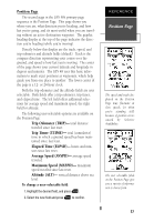
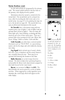
REFERENCE Marine Database Navaid labels contain abbreviated descriptions of the navaids. To view the label, highlight the navaid or zoom in until the navaid label is visible. City locations are displayed on the map. To configure the city locations, highlight OPT, press ENTER and select 'CITY SETUP'. Marine Database The GPS 48 contains an updateable, marine database that displays city locations and nautical navaids on the moving map. Check the Garmin website for possible nautical navaid updates. City locations are depicted by a small square icon, cities are displayed at the zoom scale specified on the city setup menu (see page 26). The nautical navaids contained in the GPS 48 marine database include racons, radio beacons, fog horns, daybeacons (red triangles, green squares and white diamonds), lit and unlit navaids. Each navaid is represented by a symbol on the map that will help quickly identify the type of navaid. There are 10 symbols representing the different types of navaids Foghorn Racon Radio Beacon Daybeacon (red triangle) Daybeacon (green square) Daybeacon (white diamond) Lit Navaid (color indicated in symbol) Lit Navaid (multicolor) Unlit Navaid (color indicated in symbol) Unlit Navaid (multicolor) 20
-
 1
1 -
2
-
3
-
4
-
5
-
6
-
7
-
8
-
9
-
10
-
11
-
12
-
13
-
14
-
15
-
16
-
17
-
18
-
 19
19 -
 20
20 -
 21
21 -
 22
22 -
 23
23 -
 24
24 -
 25
25 -
 26
26 -
 27
27 -
 28
28 -
 29
29 -
30
-
31
-
32
-
33
-
34
-
35
-
36
-
37
-
38
-
39
-
40
-
41
-
42
-
43
-
44
-
45
-
46
-
47
-
48
-
49
-
50
-
51
-
52
-
53
-
54
-
55
-
56
-
57
-
58
-
59
-
60
-
61
-
62
-
63
-
64
-
65
-
66
-
67
-
68
-
69
-
70
-
71
-
72
-
73
-
74
 |
 |
