Garmin GPS 48 Owner's Manual - Page 21
Position
 |
UPC - 753759007553
View all Garmin GPS 48 manuals
Add to My Manuals
Save this manual to your list of manuals |
Page 21 highlights
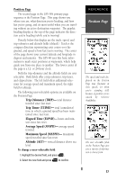
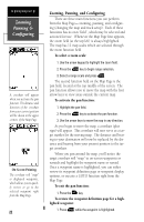
Position Page The second page in the GPS 48's primary page sequence is the Position Page. This page shows you where you are, what direction you're heading, and how fast you're going, and it's most useful when you are traveling without an active destination waypoint. The graphic heading display at the top of the page indicates the direction you're heading (while you're moving). Directly below this display are the track, speed, and trip odometer and altitude fields (default). Track is the compass direction representing your course over the ground, and speed is how fast you're moving. The center of the page shows your current latitude and longitude in degrees and minutes. The GPS 48 uses this basic information to mark exact positions as waypoints, which help guide you from one place to another. The lower center of the page is a 12- or 24-hour clock. Both the trip odometer and the altitude fields are user selectable. Both fields offer a trip odometer, trip timer, and elapsed time. The left field offers additional selections for average speed and maximum speed, the right field for altitude. The following user-selectable options are available on the Position Page: Trip Odometer (TRIP)- total distance traveled since last reset. Trip Timer (TTIME)- total (cumulative) time in which a ground speed has been maintained since last reset. Elapsed Time (ELPSD)- hours and minutes since last reset. Average Speed (AVSPD)- average speed traveled. Maximum Speed (MXSPD)- maximum speed traveled since last reset. Altitude (ALT)- vertical distance above sea level. To change a user-selectable field: 1. Highlight the desired field, and press E. 2. Select the new field and press E to confirm. REFERENCE Position Page The speed and track displayed on the Position Page may fluctuate at slow speeds (or when you're standing still) because of position errors caused by Selective Availability. The user selectable fields on the Position Page give you a variety of information to choose from. 17
-
 1
1 -
2
-
3
-
4
-
5
-
6
-
7
-
8
-
9
-
10
-
11
-
12
-
13
-
14
-
15
-
 16
16 -
 17
17 -
 18
18 -
 19
19 -
 20
20 -
 21
21 -
 22
22 -
 23
23 -
 24
24 -
 25
25 -
 26
26 -
27
-
28
-
29
-
30
-
31
-
32
-
33
-
34
-
35
-
36
-
37
-
38
-
39
-
40
-
41
-
42
-
43
-
44
-
45
-
46
-
47
-
48
-
49
-
50
-
51
-
52
-
53
-
54
-
55
-
56
-
57
-
58
-
59
-
60
-
61
-
62
-
63
-
64
-
65
-
66
-
67
-
68
-
69
-
70
-
71
-
72
-
73
-
74
 |
 |
