| Section |
Page |
| Contents |
3 |
| Chapter 1: Getting started |
6 |
| Activation and registration |
6 |
| License activation (Windows) |
6 |
| Register |
6 |
| Adobe Product Improvement Program (Windows) |
6 |
| Adobe Customization Wizard |
7 |
| Read Me |
7 |
| Help and support |
7 |
| Community Help |
7 |
| Product Help |
8 |
| Support resources |
8 |
| Services, downloads, and extras |
8 |
| Adobe creative online services |
8 |
| Adobe Exchange |
8 |
| Adobe downloads |
9 |
| Adobe Labs |
9 |
| Adobe TV |
9 |
| Extras |
9 |
| What’s new |
9 |
| PDF creation, editing, and searching |
9 |
| Collaboration |
10 |
| Forms |
10 |
| Digital signatures |
10 |
| Getting started tutorials |
10 |
| Create PDF |
11 |
| Collaborate |
13 |
| Forms |
17 |
| PDF Portfolios |
19 |
| Security |
20 |
| Chapter 2: Workspace |
23 |
| Work area basics |
23 |
| View the work area |
23 |
| Opening PDFs |
24 |
| Select another tool |
24 |
| Select a tool |
24 |
| Switch temporarily to the Zoom In or Hand tool |
24 |
| Document message bar |
25 |
| Set preferences |
25 |
| Re-create preferences |
26 |
| Re-create the Acrobat Preferences folder (Windows) |
26 |
| Re-create the Acrobat preferences files (Mac OS) |
26 |
| Customizing the work area |
26 |
| Displaying menus |
26 |
| About toolbars |
27 |
| Display and arrange toolbars |
28 |
| Show or hide toolbars |
28 |
| Move toolbars |
28 |
| Return toolbars to their default configuration |
29 |
| Lock or unlock the toolbar area |
29 |
| Show and hide toolbar elements |
29 |
| Show or hide individual tools |
29 |
| Show or hide tool labels |
29 |
| Review properties for tools and objects |
29 |
| Show or hide the navigation pane |
30 |
| Adjust navigation panels |
30 |
| Change the display area for navigation panels |
30 |
| Change the orientation of a docked navigation panel |
30 |
| View a different panel in the navigation pane |
31 |
| Dock or float navigation panels |
31 |
| Options in a navigation panel |
31 |
| Viewing PDF pages |
31 |
| Open a PDF |
31 |
| Open a PDF in the application |
32 |
| Open a PDF from the desktop or within another application |
32 |
| Opening pages in a PDF |
32 |
| Page through a document |
32 |
| Move through a PDF |
33 |
| Jump to a specific page |
33 |
| Jump to bookmarked pages |
33 |
| Use page thumbnails to jump to specific pages |
34 |
| Automatically scroll through a document |
34 |
| Retrace your viewing path |
35 |
| Change the PDF/A viewing mode |
35 |
| Navigate with links |
35 |
| PDFs with file attachments |
35 |
| Open or close reading mode |
36 |
| View PDFs in Full Screen mode |
36 |
| Set the Full Screen navigation bar preference |
36 |
| Read a document in Full Screen mode |
36 |
| Viewing PDFs in a web browser |
37 |
| Internet preferences |
37 |
| Read articles |
37 |
| Open and navigate an article thread |
37 |
| Exit a thread before the end of the article |
38 |
| Preferences for viewing PDFs |
38 |
| Documents preferences |
38 |
| Full Screen preferences |
39 |
| General preferences |
40 |
| Page Display preferences |
41 |
| Adjusting PDF views |
42 |
| Adjust page magnification |
42 |
| Resize a page to fit the window |
43 |
| Show a page at actual size |
43 |
| Change the magnification with zoom tools |
43 |
| Change the magnification with the Pan & Zoom Window tool |
43 |
| Change the magnification with the Loupe tool |
44 |
| Change the magnification by using a page thumbnail |
44 |
| Change the default magnification |
45 |
| Display off-screen areas of a magnified page |
45 |
| Set the page layout and orientation |
45 |
| Set the page layout of an open PDF |
46 |
| Rotate the page view |
46 |
| Change the default page layout (initial view) |
46 |
| Use split-window view |
47 |
| View a document in multiple windows |
47 |
| Open a new window |
47 |
| Close a window |
47 |
| Close all windows for a document |
47 |
| Display PDFs in Line Weights view |
48 |
| Grids, guides, and measurements |
48 |
| View grids |
48 |
| View or hide the grid |
48 |
| Turn the Snap To Grid option on or off |
48 |
| Change the grid appearance |
48 |
| Create ruler guides |
48 |
| Create new ruler guides |
48 |
| Show or hide guides |
49 |
| Move or delete ruler guides |
49 |
| Change guide colors |
49 |
| Measure the height, width, or area of objects |
49 |
| Measuring tool options |
50 |
| Measuring preferences |
50 |
| View cursor coordinates |
51 |
| View x and y coordinates |
51 |
| Change the Cursor Coordinates measurement units |
51 |
| Organizer |
51 |
| Organizer window overview |
51 |
| Categories pane |
52 |
| Files pane |
53 |
| Pages pane |
53 |
| Adjust the Organizer window |
53 |
| Display the Organizer window |
53 |
| Resize the Organizer and its panes |
53 |
| Sort the files pane list |
54 |
| Organize PDF collections |
54 |
| Add a PDF to a collection |
54 |
| Edit the collection folders |
54 |
| Move a PDF to a different collection |
54 |
| Remove a PDF from a collection |
54 |
| Organize PDFs with the Favorite Places category |
54 |
| Expand views in the Categories pane |
55 |
| Expand an Organizer category |
55 |
| Expand the file structure |
55 |
| Start a task from the Organizer files pane |
55 |
| Erase the history of opened PDFs |
55 |
| Maintaining the software |
55 |
| Updating the software |
55 |
| Manually update the software |
56 |
| Change updating preferences |
56 |
| Manage security settings |
56 |
| Manage plug-ins |
56 |
| Disable a plug-in |
56 |
| Disable all plug-ins temporarily |
56 |
| Adobe Digital Editions |
56 |
| Non-English languages |
57 |
| Asian language PDFs |
57 |
| Cyrillic, Central European, and Eastern European language PDFs |
57 |
| Hebrew, Arabic, Thai, and Vietnamese language PDFs |
57 |
| Enable right-to-left languages |
57 |
| Acrobat in Mac OS |
58 |
| Chapter 3: Creating PDFs |
59 |
| Overview of creating PDFs |
59 |
| What’s the best way to create a PDF? |
59 |
| PDF creation methods by file type |
59 |
| Most files |
59 |
| Paper documents |
60 |
| Microsoft Office documents |
60 |
| Email messages |
60 |
| Web pages |
60 |
| Content copied on the clipboard |
60 |
| PostScript and EPS files |
60 |
| Balancing PDF file size and quality |
61 |
| Creating simple PDFs with Acrobat |
61 |
| Convert a file to PDF using Acrobat |
61 |
| Drag and drop to create PDFs |
62 |
| Convert clipboard content to PDF (Windows) |
62 |
| Convert screen captures to PDF (Mac OS) |
62 |
| Create a PDF from a blank page |
62 |
| Create and add text to a new, blank PDF |
63 |
| Edit text in a PDF created from a blank page |
63 |
| Prevent changes in PDF Editor |
63 |
| Preferences for the PDF Editor |
63 |
| Enable Fast Web View in a PDF |
63 |
| Verify that an existing PDF is enabled for Fast Web View |
64 |
| Verify the Fast Web View Preferences setting |
64 |
| Enable Fast Web View for an existing PDF |
64 |
| Scan documents to PDF |
64 |
| Scan a paper document to PDF |
64 |
| Scan a paper document to PDF using a preset (Windows) |
65 |
| Scan a paper document to PDF without presets |
65 |
| Optimize a scanned PDF |
65 |
| Configure scanning presets (Windows) |
65 |
| Scanning options |
65 |
| Scanner Options dialog box |
66 |
| Optimization Options dialog box |
67 |
| Scanning tips |
68 |
| Recognize text in scanned documents |
68 |
| Recognize text in a single document |
68 |
| Recognize text in multiple documents |
69 |
| Recognize text in component PDFs in a PDF Portfolio |
69 |
| Recognize Text - Settings dialog box |
69 |
| Using the Adobe PDF printer |
70 |
| Create PDFs by printing to file |
70 |
| Create a PDF using the Print command (Windows) |
70 |
| Create a PDF using the Print command (Mac OS X) |
70 |
| Adobe PDF printing preferences (Windows) |
71 |
| Set Adobe PDF printer properties (Windows) |
72 |
| Set Adobe PDF printer properties |
72 |
| Reassign the port that the Adobe PDF printer uses |
72 |
| Delete a folder and reassign the Adobe PDF printer to the default port |
72 |
| Configure the Adobe PDF printer (Mac OS v10.5 and earlier) |
72 |
| Create and use a custom page size |
73 |
| Create a custom page size (Windows) |
73 |
| Create a custom page size (Mac OS) |
73 |
| Use the custom page size |
73 |
| Creating PDFs with PDFMaker (Windows) |
74 |
| About Acrobat PDFMaker |
74 |
| Convert a file to PDF using PDFMaker |
74 |
| Show or activate PDFMaker in Microsoft Office and Lotus Notes |
74 |
| Convert a file to PDF |
75 |
| Create a PDF as an email attachment |
75 |
| Attach a file as PDF (Outlook) |
75 |
| Convert files to a secured PDF and attach it to an email message (Outlook) |
75 |
| Create a PDF and send it for review |
76 |
| View PDFMaker conversion settings |
76 |
| Settings tab of the Conversion Settings |
76 |
| Security tab of the Conversion Settings |
77 |
| Convert Microsoft Word, PowerPoint, and Excel files to PDF |
77 |
| Convert Excel files to PDF |
77 |
| Convert Word and PowerPoint files to PDF |
78 |
| Convert email messages to PDFs |
78 |
| Specify whether email messages become merged PDFs or PDF Portfolios |
78 |
| Convert an open email message to PDF (Outlook) |
79 |
| Convert email messages to a new PDF |
79 |
| Add email messages or folders to an existing PDF |
79 |
| Convert email folders to a new PDF |
80 |
| Migrate old Outlook PDF archives to PDF Portfolios |
80 |
| Set up automatic email archiving |
80 |
| Create PDFs from Word mail merges |
81 |
| Email options for PDF mail merges |
82 |
| PDFs from Microsoft Project, Publisher, and Access |
82 |
| Application-specific PDFMaker settings |
82 |
| Settings tab options available from within most applications |
82 |
| Excel-specific options on the Settings tab |
83 |
| PowerPoint-specific options on the Settings tab |
83 |
| Email-specific options on the Settings tab |
83 |
| Word tab settings (Microsoft Word) |
84 |
| Bookmarks tab settings (Microsoft Word) |
84 |
| Converting web pages to PDF |
85 |
| Web pages and PDFs |
85 |
| Convert web pages to PDF in Internet Explorer (Windows) |
85 |
| Convert a web page to PDF |
86 |
| Convert part of a web page to PDF |
86 |
| Convert selected areas in a web page to PDF |
86 |
| Convert a linked web page to PDF |
87 |
| Convert web pages to PDF in Acrobat |
87 |
| Convert a web page to PDF |
87 |
| Add an unlinked web page to an existing PDF |
87 |
| Add a linked web page to an existing PDF |
88 |
| Convert a linked web page to a new PDF |
88 |
| Copy the URL of a web link |
88 |
| Change web page conversion options |
88 |
| Web page conversion options |
88 |
| General tab |
89 |
| Page Layout tab |
89 |
| HTML Conversion Settings |
89 |
| Text Settings |
90 |
| Creating PDFs with Acrobat Distiller |
90 |
| Acrobat Distiller overview |
90 |
| Manage the conversion queue |
90 |
| Queue a PostScript file |
90 |
| Change the queue during processing |
91 |
| Save a history of the job queue (Windows) |
91 |
| Clear the queue |
91 |
| Distiller preferences |
91 |
| Guidelines for creating PostScript files |
92 |
| Adobe PDF conversion settings |
92 |
| Choose an Adobe PDF preset for converting files |
92 |
| Adobe PDF presets |
92 |
| Customize Adobe PDF settings |
94 |
| Create a custom Adobe PDF settings file |
94 |
| Delete custom Adobe PDF settings files |
95 |
| Adobe PDF settings |
95 |
| General panel options |
95 |
| Images panel options |
96 |
| Fonts panel options |
97 |
| Color panel options |
98 |
| Advanced panel options |
100 |
| Standards panel options |
101 |
| PDF compatibility levels |
101 |
| Share custom PDF settings |
102 |
| Compressing and downsampling images |
103 |
| Compression methods |
103 |
| Fonts |
105 |
| Font embedding and substitution |
105 |
| Accessing and embedding fonts using Distiller |
105 |
| Preview PDFs without local fonts |
106 |
| Find PostScript font names |
106 |
| Chapter 4: PDF Portfolios and combined PDFs |
107 |
| Combining files into a PDF Portfolio |
107 |
| About PDF Portfolios |
107 |
| View the PDF Portfolio work area |
108 |
| View and edit components of a PDF Portfolio |
109 |
| View file details |
110 |
| Sort, filter, and change the order of files or folders |
110 |
| Preview component files in a PDF Portfolio |
110 |
| Open, edit, and save component files |
110 |
| Create and edit PDF Portfolios |
111 |
| Create a PDF Portfolio |
111 |
| Add files to a PDF Portfolio |
111 |
| Create a folder in a PDF Portfolio |
111 |
| Remove files and folders from a PDF Portfolio |
111 |
| Edit component filenames and descriptions in a PDF Portfolio |
111 |
| Extract component files in a PDF Portfolio |
111 |
| Share PDF Portfolios |
112 |
| Email a PDF Portfolio |
112 |
| Share a PDF Portfolio on Acrobat.com |
112 |
| Other functions enabled in PDF Portfolios |
112 |
| Other options for combining files |
112 |
| Create merged PDFs |
113 |
| File Size settings |
113 |
| Insert one PDF into another |
114 |
| Insert a clipboard selection into a PDF (Windows) |
114 |
| Placing PDFs as linked files in other documents |
114 |
| Adding unifying page elements |
114 |
| Add and edit headers and footers |
114 |
| Add headers and footers, with an open document |
115 |
| Add headers and footers, with no document open |
115 |
| Add headers and footers to component PDFs in a PDF Portfolio |
115 |
| Update the headers and footers |
116 |
| Add another header and footer |
116 |
| Replace all headers and footers |
116 |
| Remove all headers and footers |
116 |
| Add and edit backgrounds |
116 |
| Add, replace, or edit a background, with an open document |
117 |
| Add, replace, or edit a background, with no document open |
117 |
| Add, replace, or edit a background for component PDFs in a PDF Portfolio |
118 |
| Update a recently edited background image |
118 |
| Remove a background from selected pages |
118 |
| Remove a background from all pages |
118 |
| Add and edit watermarks |
118 |
| Add or replace a watermark, with an open document |
119 |
| Add or replace a watermark, with no document open |
120 |
| Add or replace a watermark in component PDFs in a PDF Portfolio |
120 |
| Update a watermark |
120 |
| Remove watermarks |
120 |
| Crop pages |
120 |
| Crop empty areas around page content |
121 |
| Crop one or more pages |
121 |
| Crop a page with the Crop tool |
121 |
| Crop Pages dialog box settings |
121 |
| Undo cropping |
121 |
| Rearranging pages in a PDF |
122 |
| Rotate a page |
122 |
| Extract pages in a PDF |
122 |
| Splitting PDFs into multiple documents |
122 |
| Split one or more PDFs, with an open document |
123 |
| Split one or more PDFs, with no document open |
123 |
| Move or copy a page |
123 |
| Move or copy a page within a PDF, using page thumbnails |
123 |
| Copy a page between two PDFs, using page thumbnails |
123 |
| Delete or replace a page |
124 |
| Delete pages, using the Delete command |
124 |
| Delete pages, using page thumbnails |
124 |
| Delete material associated with a tagged bookmark |
124 |
| Replace the contents of a page |
125 |
| Replace pages using a page thumbnail |
125 |
| Renumber pages |
125 |
| Chapter 5: Saving and exporting PDFs |
127 |
| Saving PDFs |
127 |
| Save a PDF |
127 |
| Recover the last saved version |
127 |
| About the Autosave feature |
128 |
| Recover lost changes |
128 |
| Set up automatic saving |
128 |
| Recover lost changes after an unexpected shutdown |
128 |
| Reduce file size by saving |
128 |
| Exporting PDFs to other file formats |
129 |
| Exporting PDFs |
129 |
| Export a single PDF |
129 |
| Export multiple PDFs |
130 |
| File format options |
130 |
| PostScript or Encapsulated PostScript (EPS) options |
130 |
| HTML or XML options |
130 |
| JPEG and JPEG 2000 options |
131 |
| PNG options |
132 |
| TIFF options |
132 |
| Convert PDFs to Word, RTF, or other text formats |
133 |
| Word and RTF options |
133 |
| Export images to another format |
133 |
| Reusing PDF content |
134 |
| Select and copy text |
134 |
| Select a column of text |
134 |
| Select all the text on a page |
134 |
| Copy selected text |
135 |
| Convert tables to spreadsheets |
135 |
| Copy images |
135 |
| Take a snapshot of a page |
136 |
| Chapter 6: Collaboration |
137 |
| File sharing and real-time collaboration |
137 |
| Upload documents to Acrobat.com |
137 |
| Share documents with others |
137 |
| Create and edit a collaborative document |
137 |
| Collaborate with others in a PDF |
138 |
| Initiate a Collaborate Live session |
138 |
| Participate in a Collaborate Live session |
138 |
| Collaborate in online meetings |
139 |
| Start a meeting |
139 |
| Attend a meeting |
139 |
| Acrobat.com preferences |
139 |
| Preparing for a PDF review |
140 |
| About managed PDF reviews |
140 |
| Choosing a distribution option for reviews and forms |
141 |
| Select an email application for reviews |
142 |
| Specify a server |
142 |
| Starting a review |
143 |
| Start a shared review |
143 |
| Start an email-based review |
144 |
| Start the review |
144 |
| Merge comments |
144 |
| Participating in a PDF review |
145 |
| Review a PDF |
145 |
| Join a review |
145 |
| Options in the document message bar |
146 |
| Check for newly published comments |
146 |
| Send comments in email |
147 |
| Publish comments from other reviewers |
147 |
| Rejoin a review |
147 |
| Tracking and managing PDF reviews |
148 |
| Tracker overview |
148 |
| Track reviewed PDFs |
149 |
| Save the PDF with comments |
149 |
| Invite additional reviewers |
150 |
| Add or change a deadline |
150 |
| End a review |
150 |
| Start a shared review with the same reviewers from an existing review |
150 |
| Send a message |
150 |
| Update your profile |
151 |
| Update your review profile |
151 |
| Update your profile for a shared review |
151 |
| Subscribe to web broadcast services |
151 |
| Tracker preferences |
151 |
| Commenting |
151 |
| Commenting and markup tools overview |
151 |
| Show the Comment & Markup toolbar |
153 |
| Select a commenting or markup tool |
153 |
| Keep a commenting tool selected |
153 |
| Commenting preferences |
153 |
| Change the look of your comments |
154 |
| Change a comment’s look and set it as the default |
155 |
| Set the default look for a tool |
155 |
| Add a sticky note |
155 |
| Add a sticky note comment |
155 |
| Edit a sticky note comment |
156 |
| Delete a sticky note |
156 |
| Mark up text with edits |
156 |
| Replace text |
157 |
| Add a note to a text edit |
157 |
| Show inserted text |
157 |
| Delete inserted text |
157 |
| Delete text markups |
158 |
| Highlight, cross out, or underline text |
158 |
| Stamp a document |
158 |
| Open the Stamps palette |
159 |
| Apply a stamp |
159 |
| Change a stamp’s location or appearance |
159 |
| Move a stamp to the favorites list |
159 |
| Create a custom stamp |
160 |
| Change the name or category for a custom stamp |
160 |
| Delete a custom stamp |
160 |
| Delete a custom stamp category |
160 |
| Add a line, arrow, or shape |
160 |
| Group and ungroup markups |
161 |
| Group markups |
161 |
| Ungroup markups |
161 |
| Add comments in a text box or callout |
161 |
| Add a text box |
162 |
| Add a callout |
163 |
| Add an audio comment |
163 |
| Add a prerecorded audio comment |
163 |
| Record an audio comment |
163 |
| Add comments in a file attachment |
164 |
| Paste images as comments |
164 |
| Managing comments |
165 |
| View comments |
165 |
| Open the Comments list |
165 |
| Sort comments |
165 |
| Show or hide comments |
166 |
| Reply to comments |
166 |
| Reply in the pop-up note |
166 |
| Reply in the Comments list |
167 |
| Delete a reply |
167 |
| Set a status or check mark |
167 |
| Set a status |
167 |
| Flag comments with a check mark |
167 |
| Print a comment summary |
167 |
| Find a comment |
168 |
| Delete comments |
169 |
| Delete a comment |
169 |
| Unlock a comment |
169 |
| Spell-check all text in comments |
169 |
| Importing and exporting comments |
169 |
| Import Comments |
169 |
| Export comments |
170 |
| Export comments to a data file |
170 |
| Export selected comments |
170 |
| Export comments to Word (Windows) |
170 |
| Approval workflows |
171 |
| About approval workflows |
171 |
| Participate in an approval workflow |
172 |
| Approve a PDF |
172 |
| Reject a PDF |
173 |
| Add or change identity information for a digital stamp |
173 |
| Chapter 7: Forms |
174 |
| Forms basics |
174 |
| About forms |
174 |
| About LiveCycle Designer ES |
174 |
| Forms preferences |
175 |
| General |
175 |
| Highlight Color |
176 |
| Auto-Complete |
176 |
| Creating and distributing forms |
176 |
| About form elements |
176 |
| Create forms using Acrobat |
178 |
| Create online forms using FormsCentral |
178 |
| Enable Reader users to save form data |
179 |
| Adding JavaScript to forms |
179 |
| Create form fields |
180 |
| Create a new form field |
180 |
| Lay out form fields on a grid |
180 |
| Copy a form field |
181 |
| Create a copy of a form field |
181 |
| Create multiple copies of a form field on a page |
181 |
| Duplicate a form field across multiple pages |
181 |
| Select multiple form fields |
182 |
| Resize and arrange form fields |
182 |
| Resize a form field |
182 |
| Resize multiple form fields to match a selected form field |
182 |
| Move individual form fields |
183 |
| Align and center multiple form fields |
183 |
| Adjust the spacing between form fields |
183 |
| Delete a form field |
183 |
| About barcodes |
184 |
| Create, test, and edit barcode fields |
185 |
| Add a barcode field |
185 |
| Test a barcode field |
185 |
| Include additional data fields in the barcode |
186 |
| Adjust data content to fit in a barcode field |
186 |
| Set form field navigation |
187 |
| Set tabbing order in edit mode |
187 |
| Set tabbing order in Page Properties |
187 |
| Distribute (send) forms to recipients |
187 |
| Form fields behavior |
188 |
| About form field properties |
188 |
| Modify form field properties |
189 |
| General tab for form field properties |
189 |
| Appearance tab for form field properties |
189 |
| Options tab for form field properties |
190 |
| Barcode |
190 |
| Check boxes |
191 |
| Combo box and list box |
191 |
| Radio buttons |
192 |
| Text Fields |
192 |
| Actions tab for form field properties |
193 |
| Calculate tab for form field properties |
193 |
| Set the calculation order of form fields |
193 |
| Signed tab for form field properties |
194 |
| Format tab for form field properties |
194 |
| None |
194 |
| Number |
194 |
| Percentage |
194 |
| Date |
194 |
| Time |
195 |
| Special |
195 |
| Custom |
196 |
| Validation tab for form field properties |
196 |
| Value tab for form field properties |
196 |
| Manage custom barcode settings |
197 |
| Create a new barcode parameters set |
197 |
| Edit or delete a set of custom barcode parameters |
197 |
| Export or import a set of custom barcode parameters |
197 |
| Redefine form field property defaults |
198 |
| Setting action buttons |
198 |
| About buttons |
198 |
| Add a button to an Acrobat PDF form |
198 |
| Add a submit button |
199 |
| Submit Form Selections options |
199 |
| Making buttons change appearance |
200 |
| Edit a button |
200 |
| Specify Acrobat button display properties |
200 |
| Button Behavior options |
200 |
| Scale and position buttons |
201 |
| Hide an Acrobat button except during rollover |
201 |
| Publishing interactive web forms |
202 |
| About web forms |
202 |
| Add submit functionality |
202 |
| Submit Form Selections options |
203 |
| Add a Reset Form button |
203 |
| Add an Import Data button |
204 |
| CGI export values |
204 |
| Collecting and managing form data |
205 |
| Collect user data |
205 |
| Compile form data |
205 |
| Add user data to an existing response file |
205 |
| Export user data from a response file |
205 |
| Manage form data files |
206 |
| Import form data |
206 |
| Export form data |
206 |
| Merge exported data files to a spreadsheet |
206 |
| About Forms Tracker |
207 |
| Filling in forms |
207 |
| Is the form fillable? |
207 |
| Fill in flat forms |
208 |
| Fill in flat forms in a browser |
209 |
| Fill in interactive forms |
209 |
| Options for moving among form fields |
209 |
| Auto-Complete forms (interactive forms only) |
210 |
| Enable the Auto-Complete option |
210 |
| Delete an entry from the Auto-Complete memory |
210 |
| Change flat forms to fillable |
210 |
| Save forms |
211 |
| Print forms |
211 |
| Clear forms |
211 |
| Clear a form in a browser |
211 |
| Clear unsaved form entries |
211 |
| Sample forms |
211 |
| Chapter 8: Security |
213 |
| Opening secured documents |
213 |
| Security alerts |
213 |
| Enhanced security |
215 |
| Enable enhanced security |
215 |
| Bypassing enhanced security restrictions |
215 |
| Specify privileged locations for trusted content |
216 |
| Restrict URLs and attachments in PDFs |
216 |
| Trust Manager preferences |
216 |
| Open secured PDFs |
217 |
| Sign a document |
218 |
| Certify a document |
218 |
| Choosing a security method |
219 |
| Choosing which type of security to use |
219 |
| Choosing security methods within FIPS mode (Windows) |
220 |
| Securing documents with passwords |
221 |
| Add password security |
221 |
| Password security options |
222 |
| Remove password security |
223 |
| Securing documents with certificates |
223 |
| Certificate security |
223 |
| Encrypt a PDF with a certificate |
224 |
| Change or remove encryption from a PDF |
224 |
| Change encryption settings |
224 |
| Remove encryption settings |
225 |
| Sharing certificates with others |
225 |
| Get certificates from other users |
225 |
| Request a certificate from another user |
225 |
| Add a certificate from email |
226 |
| Add a certificate from a digital signature in a PDF |
226 |
| Import a certificate |
226 |
| Set up Acrobat to search the Windows certificate store (Windows only) |
227 |
| Import certificates using the Windows Certificate Wizard (Windows only) |
227 |
| Associate a certificate with a contact |
227 |
| Verify information on a certificate |
228 |
| Verify your own certificate |
228 |
| Verify information on the certificate of a contact |
228 |
| Set the trust level of a certificate |
228 |
| Delete a certificate from trusted identities |
229 |
| Use directory servers to store user certificates |
229 |
| Import directory server settings (Windows only) |
229 |
| Export directory server settings (Windows only) |
230 |
| Securing documents with Adobe LiveCycle Rights Management ES |
230 |
| Adobe LiveCycle Rights Management ES |
230 |
| Connect to Adobe LiveCycle Rights Management ES |
231 |
| View Adobe LiveCycle Rights Management ES policies |
231 |
| Setting up security policies |
231 |
| Types of security policies |
231 |
| How organizational policies are authenticated |
231 |
| Create a user security policy |
232 |
| Create a password policy |
232 |
| Create a certificate policy |
233 |
| Creating policies for secure file attachments |
233 |
| Create a user security policy with Adobe LiveCycle Rights Management ES |
234 |
| Apply security policies to PDFs |
235 |
| Apply a security policy to a PDF |
235 |
| Apply a policy to attachments in Outlook |
235 |
| Remove a user security policy from a PDF |
235 |
| Export security settings |
236 |
| Copy, edit, or delete a policy |
236 |
| Revoke a policy-protected PDF |
236 |
| Creating or obtaining digital IDs |
237 |
| About digital IDs |
237 |
| Register a digital ID |
238 |
| Create a new digital ID |
238 |
| Set up a roaming ID account |
239 |
| Smart cards and hardware tokens |
239 |
| Specify the default digital ID |
239 |
| Change the password and timeout for a digital ID |
240 |
| Delete your digital ID |
240 |
| Protecting digital IDs |
241 |
| Removing sensitive content |
241 |
| Preparing PDFs for distribution |
241 |
| Examine a PDF for hidden content |
242 |
| Chapter 9: Digital signatures |
243 |
| Digital signatures |
243 |
| About digital signatures |
243 |
| Create the signature appearance |
244 |
| Set signing preferences |
245 |
| Add a timestamp to signatures |
245 |
| Configure a timestamp server |
245 |
| Set a timestamp server as the default |
246 |
| About graphics tablet signatures |
246 |
| Signing PDFs |
246 |
| Before you sign a PDF |
246 |
| Sign a PDF |
247 |
| Sign a PDF with a digital signature |
247 |
| Sign a PDF with an ink signature |
248 |
| Sign in Preview Document mode |
249 |
| Sign a PDF in Preview Document mode |
249 |
| Before you certify a PDF |
249 |
| Certify a PDF |
249 |
| Clear or remove a digital signature |
250 |
| Customizing signature properties using seed values |
250 |
| Validating signatures |
251 |
| Checking the validity of a signature |
251 |
| Validate a signature manually |
251 |
| Establish long-term signature validation |
252 |
| Add verification information at signing |
252 |
| Add verification information after signing |
252 |
| Set signature verification preferences |
252 |
| Signatures panel overview |
253 |
| Display the Signatures panel |
254 |
| Validate a timestamp certificate |
254 |
| View previous versions of a signed document |
254 |
| Compare versions of a signed document |
255 |
| Chapter 10: Accessibility, tags, and reflow |
256 |
| Accessibility features |
256 |
| About accessibility features |
256 |
| About accessible PDFs |
257 |
| About tags, accessibility, reading order, and reflow |
258 |
| Checking the accessibility of PDFs |
258 |
| About accessibility checkers |
258 |
| Check accessibility with Quick Check |
259 |
| Accessibility Quick Check results |
259 |
| Reading PDFs with reflow and accessibility features |
260 |
| Setting accessibility preferences |
260 |
| Set accessibility preferences with the Accessibility Setup Assistant |
260 |
| Set accessibility preferences with the Preferences dialog box |
260 |
| Accessibility preferences |
260 |
| Navigate and control the application with the keyboard |
263 |
| Enable single-key accelerators |
263 |
| Scroll automatically |
263 |
| Save as accessible text for a braille printer |
264 |
| Reflow a PDF |
264 |
| Reflow a tagged PDF |
265 |
| Return to unreflowed view |
265 |
| Reading a PDF with a screen reader |
265 |
| Read a PDF with Read Out Loud |
265 |
| Activate or deactivate Read Out Loud |
266 |
| Read a PDF with Read Out Loud |
266 |
| Read PDF form fields out loud |
266 |
| Interrupt reading out loud |
266 |
| About operating system accessibility tools |
266 |
| Creating accessible PDFs |
267 |
| Workflow for creating accessible PDFs |
267 |
| Consider accessibility before you convert a document to PDF |
267 |
| Add fillable form fields and descriptions, and set the tab order |
267 |
| Add other accessibility features to the PDF |
267 |
| Tag the PDF |
268 |
| Create a tagged PDF from a web page |
268 |
| Creating a tagged PDF from an authoring application |
268 |
| About tags in combined PDFs |
269 |
| About tools for creating accessible PDF forms |
270 |
| Workflow for creating accessible PDF forms |
270 |
| Making existing PDFs accessible |
271 |
| Add tags to an existing PDF |
271 |
| Make Adobe PDF forms accessible |
271 |
| Set the document language |
272 |
| Prevent security settings from interfering with screen readers |
272 |
| About watermarks and screen readers |
272 |
| Chapter 11: Editing PDFs |
273 |
| Page thumbnails and bookmarks |
273 |
| About page thumbnails |
273 |
| Create page thumbnails |
273 |
| Create page thumbnails |
274 |
| Resize page thumbnails |
274 |
| Define the tabbing order |
274 |
| About bookmarks |
274 |
| Create a bookmark |
275 |
| Edit a bookmark |
276 |
| Rename a bookmark |
276 |
| Wrap text in a long bookmark |
276 |
| Change the text appearance of a bookmark |
276 |
| Change a bookmark’s destination |
276 |
| Add an action to a bookmark |
276 |
| Delete a bookmark |
276 |
| Create a bookmark hierarchy |
277 |
| Nest one or more bookmarks |
277 |
| Move bookmarks out of a nested position |
277 |
| Expand or collapse all top-level bookmarks |
277 |
| Add tagged bookmarks |
278 |
| Links and attachments |
278 |
| Create a link |
278 |
| Create a link using the Link tool |
278 |
| Create a link using the Select tool or Snapshot tool |
279 |
| Edit a link |
279 |
| Move or resize a link rectangle |
279 |
| Change the appearance of a link |
279 |
| Edit a link action |
280 |
| Delete a link |
280 |
| Create web links from URLs |
280 |
| Create web links |
280 |
| Remove all web links |
280 |
| Link to a file attachment |
280 |
| Destinations |
280 |
| View and manage destinations |
281 |
| View destinations |
281 |
| Sort the destinations list |
281 |
| Change or delete a destination |
281 |
| Create and link a destination |
281 |
| Add an attachment |
281 |
| Open, save, or delete an attachment |
282 |
| Open an attachment |
282 |
| Save an attachment |
282 |
| Delete an attachment |
283 |
| Search in attachments |
283 |
| Search attachments from the Attachments panel |
283 |
| Search attachments from the Search window |
283 |
| Actions and scripting |
283 |
| About Actions |
283 |
| Add an action |
283 |
| Add actions with page thumbnails |
284 |
| Action types |
284 |
| Trigger types |
285 |
| About JavaScript in Acrobat |
285 |
| Converted web pages |
285 |
| Links and bookmarks in web pages |
285 |
| Get information on converted web pages |
286 |
| Compare converted pages with current web pages |
286 |
| Articles |
286 |
| About articles |
286 |
| Define articles |
287 |
| View and edit an article |
287 |
| View articles on the page |
287 |
| View articles in the PDF |
287 |
| Delete an article or article box |
288 |
| Insert an article box into an article thread |
288 |
| Move or resize an article box |
288 |
| Edit article properties |
288 |
| Combine two articles |
289 |
| Editing text and objects |
289 |
| Choosing a tool |
289 |
| Edit text |
289 |
| Edit text using the TouchUp Text tool |
290 |
| Replace custom fonts with local fonts |
290 |
| Edit text attributes |
291 |
| Add new text |
291 |
| Add text using the Typewriter tool |
292 |
| Embed fonts using the TouchUp Text tool |
292 |
| Move or edit an object |
293 |
| Select an object |
293 |
| Move an object |
294 |
| Resize an object |
294 |
| Setting up a presentation |
294 |
| Defining initial view as Full Screen mode |
294 |
| Define an initial view |
295 |
| Define the initial view |
295 |
| Define the initial view as Full Screen mode |
295 |
| Initial View options for document properties |
296 |
| Add page transitions |
296 |
| Document properties and metadata |
297 |
| View document properties |
297 |
| Document Properties |
297 |
| Add a description to Document Properties |
298 |
| Create document properties |
298 |
| Edit document metadata |
298 |
| View document metadata |
299 |
| Edit or append document metadata |
299 |
| Save metadata as a template or file |
299 |
| View object data and metadata |
299 |
| View and edit Visio object metadata |
300 |
| Export Visio object metadata |
300 |
| Layers |
301 |
| About PDF layers |
301 |
| Show or hide layers |
301 |
| Reorder layers |
302 |
| Delete an empty layer group |
302 |
| Add layer navigation |
302 |
| Associate layer visibility with bookmarks |
302 |
| Associate layer visibility with a link destination |
302 |
| Editing layered content |
303 |
| Using Geospatial PDFs |
303 |
| About geospatial PDFs |
303 |
| Interact with geospatial PDFs |
304 |
| Find map locations |
304 |
| Mark geospatial locations |
304 |
| Measure distance, perimeter, and area on maps |
305 |
| Copy location coordinates to the clipboard for use with a web mapping service |
305 |
| Change measurement units within a document |
305 |
| Change geospatial measuring preferences |
305 |
| Export location and measurement markups |
306 |
| Chapter 12: Searching and indexing |
307 |
| Searching PDFs |
307 |
| Search features overview |
307 |
| Access the search features |
307 |
| Display the Find toolbar |
307 |
| Open the Search window |
308 |
| Arrange the PDF document window and Search window |
308 |
| Find text in a PDF |
308 |
| Find text in multiple PDFs |
308 |
| Search a PDF Portfolio |
309 |
| Review search results |
309 |
| Jump to a specific instance in the search results (single PDFs only) |
309 |
| Sort instances in the search results |
309 |
| Icons shown with search results |
310 |
| Advanced Search Options |
310 |
| Boolean operators |
311 |
| Search index files of cataloged PDFs |
312 |
| Search features preferences |
312 |
| Creating PDF indexes |
313 |
| Create and manage an index in a PDF |
313 |
| Add an index to a PDF |
313 |
| Update or remove the embedded index in a PDF |
313 |
| Chapter 13: Multimedia and 3D models |
314 |
| Multimedia in PDFs |
314 |
| Play multimedia |
314 |
| Multimedia preferences |
314 |
| Multimedia Trust preferences |
315 |
| Multimedia Trust (Legacy) |
315 |
| Interacting with 3D models |
316 |
| Displaying 3D models |
316 |
| 3D toolbar overview |
316 |
| 3D navigation tools |
317 |
| 3D toolbar view controls |
317 |
| Examples of model rendering modes |
318 |
| Change rendering mode, lighting, projection, and background |
319 |
| Model Tree overview |
319 |
| Hide, isolate, and change the appearance of parts |
320 |
| Create cross sections |
322 |
| Cross-section properties |
322 |
| Measure 3D objects |
323 |
| Snap Enables options in the 3D Measurement Tool palette |
324 |
| Measurement Types options in the 3D Measurement Tool palette |
324 |
| Units and markup options |
325 |
| Measuring preferences |
325 |
| Change camera properties |
326 |
| Set 3D views |
327 |
| Create a custom view |
327 |
| Display a view |
327 |
| Change the default view |
327 |
| Add a 3D view to a bookmark or link |
327 |
| Delete a 3D view |
328 |
| 3D preferences |
328 |
| Comment on 3D designs |
329 |
| Add a 3D Comment to an object |
330 |
| Add comments from the Comment & Markup toolbar |
330 |
| Convert 3D measurements to comments |
330 |
| Display comments for a 3D object |
330 |
| Run a JavaScript |
331 |
| Chapter 14: Color management |
332 |
| Understanding color management |
332 |
| Why colors sometimes don’t match |
332 |
| What is a color management system? |
332 |
| Do you need color management? |
333 |
| Creating a viewing environment for color management |
333 |
| Keeping colors consistent |
334 |
| About color management in Adobe applications |
334 |
| Basic steps for producing consistent color |
335 |
| Synchronize color settings across Adobe applications |
335 |
| Set up color management |
336 |
| Change the appearance of CMYK black (Illustrator, InDesign) |
336 |
| Managing process and spot colors |
337 |
| Color-managing imported images |
337 |
| Color-managing imported images (Illustrator, InDesign) |
337 |
| Using a safe CMYK workflow |
338 |
| Preparing imported graphics for color management |
338 |
| View or change profiles for imported bitmap images (InDesign) |
338 |
| Color-managing documents for online viewing |
339 |
| Color-managing documents for online viewing |
339 |
| Color-managing PDFs for online viewing |
339 |
| Color-managing HTML documents for online viewing |
339 |
| Proofing colors |
340 |
| Soft-proofing colors |
340 |
| Soft-proof colors |
340 |
| Soft-proof presets |
340 |
| Custom soft-proof options |
341 |
| Save or load a custom proof setup (Photoshop, InDesign) |
341 |
| Color-managing documents when printing |
341 |
| Printing with color management |
341 |
| Letting the printer determine colors when printing |
342 |
| Letting the application determine colors when printing |
342 |
| Obtaining custom profiles for desktop printers |
342 |
| Working with color profiles |
343 |
| About color profiles |
343 |
| About monitor calibration and characterization |
344 |
| Calibrate and profile your monitor |
345 |
| Install a color profile |
345 |
| Embed a color profile |
345 |
| Embed a color profile (Acrobat) |
346 |
| Changing the color profile for a document |
346 |
| Assign or remove a color profile (Illustrator, Photoshop) |
346 |
| Assign or remove a color profile (InDesign) |
346 |
| Convert document colors to another profile (Photoshop) |
347 |
| Color settings |
347 |
| Customize color settings |
347 |
| About color working spaces |
348 |
| Working space options |
348 |
| About missing and mismatched color profiles |
349 |
| Color management policy options |
350 |
| Color conversion options |
350 |
| About rendering intents |
351 |
| Advanced controls in Photoshop |
351 |
| Chapter 15: Printing |
353 |
| Basic printing tasks |
353 |
| Print a PDF |
353 |
| Options in the Print dialog box |
353 |
| Print a portion of a page |
355 |
| Print layers |
355 |
| View how layers print |
356 |
| Change print settings for a layer |
356 |
| Create print presets |
356 |
| Print Dialog Presets |
356 |
| Other ways to print PDFs |
357 |
| About booklets |
357 |
| Print a booklet |
357 |
| Print PDFs in a PDF Portfolio |
358 |
| Print from the Bookmarks tab |
359 |
| Printing custom sizes |
359 |
| Print an oversized document |
359 |
| Scale a document for printing |
360 |
| Advanced print settings |
360 |
| About advanced print settings |
360 |
| Set advanced print options |
360 |
| PostScript options |
361 |
| Downloading Asian fonts to a printer |
361 |
| Chapter 16: Keyboard shortcuts |
363 |
| Keyboard shortcuts |
363 |
| Keys for selecting tools |
363 |
| Keys for working with comments |
363 |
| Keys for navigating a PDF |
364 |
| Keys for general navigating |
365 |
| Keys for working with navigation panels |
365 |
| Keys for navigating the Help window |
366 |
| Keys for accessibility |
367 |
| Index |
368 |
| Numerics |
368 |
| A |
368 |
| B |
369 |
| C |
369 |
| D |
371 |
| E |
372 |
| F |
372 |
| G |
373 |
| H |
373 |
| I |
373 |
| J |
374 |
| K |
374 |
| L |
374 |
| M |
374 |
| N |
375 |
| O |
375 |
| P |
375 |
| Q |
377 |
| R |
377 |
| S |
378 |
| T |
379 |
| U |
379 |
| V |
380 |
| W |
380 |
| X |
380 |

 1
1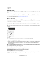 301
301 302
302 303
303 304
304 305
305 306
306 307
307 308
308 309
309 310
310 311
311

