Garmin GPSMAP 5212 Installation Instructions - Page 10
Garmin GPSMAP 5212 - Marine GPS Receiver Manual
 |
UPC - 753759066109
View all Garmin GPSMAP 5212 manuals
Add to My Manuals
Save this manual to your list of manuals |
Page 10 highlights
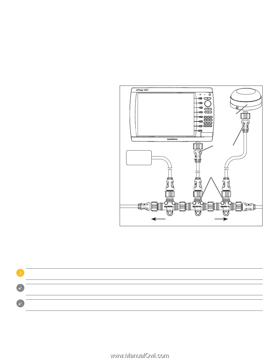
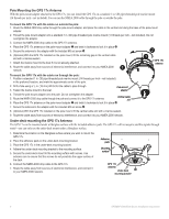
Connecting the GPSMAP 4000/5000 Series Chartplotter and the GPS 17x Antenna to Your NMEA 2000 Network The GPSMAP 4000/5000 series chartplotter is packaged with the necessary NMEA 2000 connectors and cable to either connect the GPSMAP 4000/5000 series chartplotter and GPS 17x antenna to your existing NMEA 2000 network, or to build a basic NMEA 2000 network. For more information on NMEA 2000, visit www.garmin.com. Connecting to an Existing NMEA 2000 network If your boat already has a NMEA 2000 network installed, use the included T-connectors and drop cable to connect the GPSMAP 4000/5000 series chartplotter and GPS 17x antenna to the existing network. To connect the GPSMAP 4000/5000 series chartplotter and GPS 17x to your existing NMEA 2000 network: 1. Determine the appropriate locations to connect the GPSMAP 4000/5000 series chartplotter and GPS 17x to your existing NMEA 2000 backbone. 2. Disconnect one side of a NMEA 2000 T-connector from the backbone nearest to the location where you want to connect the chartplotter. If you need to extend the NMEA 2000 backbone, connect an appropriate NMEA 2000 backbone extension cable (not included) to the side of the T-connector you disconnected. GPSMAP 4000/5000 series chartplotter GPS 17x antenna 3. Connect an included T-connector in the NMEA 2000 backbone (for the chartplotter). 4. Route an included drop cable to the chartplotter and to the top of the T-connector you added to your NMEA 2000 network. If the included drop cable is not long enough, you can add a drop cable extension up to 13 ft. (4 m). If more cable is needed, add an extension to your NMEA 2000 backbone, based on the NMEA 2000 guidelines. NMEA 2000 device (not included) Drop cables (included) T-connectors (included) 5. Disconnect one side of a NMEA 2000 T-connector from the backbone nearest to the location where you want to connect the GPS 17x antenna. If you need to extend the NMEA 2000 backbone, connect an appropriate NMEA 2000 backbone extension cable (not included) to the side of the T-connector you disconnected. 6. Connect an included T-connector in the NMEA 2000 backbone (for the GPS 17x antenna). Existing NMEA 2000 network (not included) Connecting the GPSMAP 4000/5000 Series Chartplotter and GPS 17x Antenna to an Existing NMEA 2000 Network 7. Route an included drop cable from the GPS 17x antenna to the top of the T-connector you added to your NMEA 2000 network. If the included drop cable is not long enough, you can add a drop cable extension up to 13 ft. (4 m). If more cable is needed, add an extension to your NMEA 2000 backbone, based on the NMEA 2000 guidelines. Caution: If you have an existing NMEA 2000 network on your boat, it should already be connected to power. Do not connect the included NMEA 2000 power cable to an existing NMEA 2000 network. Note: The diagram shows only the NMEA 2000 data connection to the GPSMAP 4000/5000 series chartplotter. The chartplotter must also be connected to power or it will not function. See page 9. Note: One GPS antenna will provide position data for every device on the NMEA 2000 network. Do not connect multiple GPS antennas if you are using multiple chartplotters. 10 GPSMAP 4000/5000 Series Installation Instructions
-
 1
1 -
2
-
3
-
4
-
 5
5 -
 6
6 -
 7
7 -
 8
8 -
 9
9 -
 10
10 -
 11
11 -
 12
12 -
 13
13 -
 14
14 -
 15
15 -
16
-
17
-
18
-
19
-
20
-
21
-
22
-
23
-
24
 |
 |