Garmin GPSMAP 5212 Installation Instructions - Page 21
Specifications, NMEA 2000 PGN Information, Physical Specifications, Power - update
 |
UPC - 753759066109
View all Garmin GPSMAP 5212 manuals
Add to My Manuals
Save this manual to your list of manuals |
Page 21 highlights
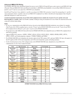
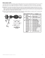
Specifications Physical Specifications Size: GPSMAP 4008: 7 in. H × 11 /13 64 in. W × 4 /13 64 in. D (176.9 × 284.4 × 106 mm) GPSMAP 4010: 8 /29 32 in. H × 13 /13 32 in. W × 4 1/8 in. D (226.9 × 340.4 × 105.1 mm) GPSMAP 4012: 9 1/2 in. H × 14 /51 64 in. W × 4 1/8 in. D (240.5 × 375 × 105.1 mm) GPSMAP 5008: 6 /51 64 in. H × 10 3/32 in. W × 4 /11 64 in. D (173.5 × 256 × 105.9 mm) GPSMAP 5012: 9 /15 32 in. H × 13 in. W × 4 /45 64 in. D (240.5 × 330 × 119.2 mm) GPSMAP 5015: 11 /21 32 in. H × 15 /35 64 in. W × 5 /21 32 in. D (295.8 × 394.9 × 143.8 mm) Weight: GPSMAP 4008: GPSMAP 4010: GPSMAP 4012: GPSMAP 5008: GPSMAP 5012: GPSMAP 5015: 6 lb. (2.7 kg) 8 lb. (3.6 kg) 10 lb. (4.5 kg) 6 lb. (2.7 kg) 10 lb. (4.5 kg) 12 lb. (5.4 kg) Display: GPSMAP 4008: GPSMAP 4010: GPSMAP 4012: GPSMAP 5008: GPSMAP 5012: GPSMAP 5015: 5 /11 64 in. H × 6 /27 32 in. W (131.4 × 174 mm) 6 /11 32 in. H × 8 7/16 in. W (161.4 × 214.2 mm) 7 /19 64 in. H × 9 /11 16 in. W (184.3 × 245.8 mm) 5 in. H × 6 /47 64 in. W (128.2 × 170.9 mm) 7 7/64 in. H × 9 /19 64 in. W (180.49 × 235.97 mm) 8 /63 64 in. H × 11 /31 32 in. W (228.1 × 304.1 mm) Case: Fully Gasketed, high-impact plastic and aluminum alloy, waterproof to IEC 529-IPX Temp. Range: from 5°F to 131°F (from -15°C to 55°C) Compass Safe Distance GPSMAP 4008/5008: 31 1/2 in. (80 cm) GPSMAP 4012/5012: 39 3/8 in. (1 m) GPSMAP 4010/4210: 31 1/2 in. (80 cm) GPSMAP 5015: 23 5/8 in. (60 cm) Power Source: 10-35 Vdc Usage: GPSMAP 4008/5008: 35 W max. at 10 Vdc NMEA 2000 PGN Information Receive 059392 ISO Acknowledgment 059904 ISO Request 060928 ISO Address Claim 126208 NMEA - Command/Request/Acknowledge Group Function 126464 Transmit/Receive PGN List Group Function 126992 System Time 126996 Product Information 127250 Vessel Heading 127489 Engine Parameters - Dynamic 127488 Engine Parameters - Rapid Update 127505 Fluid Level 128259 Speed - Water Referenced 128267 Water Depth 129025 Position - Rapid Update 129026 COG & SOG - Rapid Update 129029 GNSS Position Data 129539 GNSS DOPs 129540 GNSS Sats in View 130306 Wind Data 130310 Environmental Parameters 130311 Environmental Parameters 130312 Temperature 130313 Humidity 130314 Actual Pressure Transmit 059392 059904 060928 126208 126464 126996 127250 128259 128267 129025 129026 129029 129540 130306 130312 ISO Acknowledgment ISO Request ISO Address Claim NMEA - Command/Request/Acknowledge Group Function Transmit/Receive PGN List Group Function Product Information Vessel Heading Speed - Water Referenced Water Depth Position - Rapid Update COG & SOG - Rapid Update GNSS Position Data GNSS Sats in View Wind Data Temperature GPSMAP 4000/5000 series chartplotters are NMEA 2000 certified. GPSMAP 4000/5000 Series Installation Instructions 21
-
 1
1 -
2
-
3
-
4
-
5
-
6
-
7
-
8
-
9
-
10
-
11
-
12
-
13
-
14
-
15
-
 16
16 -
 17
17 -
 18
18 -
 19
19 -
 20
20 -
 21
21 -
 22
22 -
 23
23 -
 24
24
 |
 |