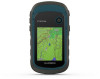
Garmin eTrex 22x/32x Owners Manual - Page 12
Profiles, System Settings, Display Settings, Setting the Device Tones, Changing the Units of Measure
 |
View all Garmin eTrex 22x/32x manuals
Add to My Manuals
Save this manual to your list of manuals |
Page 12 highlights
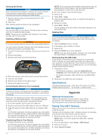
Time To Destination: The estimated time remaining before you reach the destination. You must be navigating for this data to appear. Time To Next: The estimated time remaining before you reach the next waypoint in the route. You must be navigating for this data to appear. To Course: The direction in which you must move to get back on the route. You must be navigating for this data to appear. Total Lap: The stopwatch time for all the completed laps. Track Distance: The distance traveled for the current track. Trip Odometer: A running tally of the distance traveled since the last reset. Trip Time: A running tally of the total time spent moving and not moving since the last reset. Trip Time - Moving: A running tally of the time spent moving since the last reset. Trip Time - Stopped: A running tally of the time spent not moving since the last reset. Turn: The angle of difference (in degrees) between the bearing to your destination and your current course. L means turn left. R means turn right. You must be navigating for this data to appear. Velocity Made Good: The speed at which you are closing on a destination along a route. You must be navigating for this data to appear. Vertical Dist to Dest: The elevation distance between your current position and the final destination. You must be navigating for this data to appear. Vertical Speed: The rate of ascent or descent over time. Vertical Speed To Dest: The rate of ascent or descent to a predetermined altitude. You must be navigating for this data to appear. Waypoint At Dest: The last point on the route to the destination. You must be navigating for this data to appear. Waypoint At Next: The next point on the route. You must be navigating for this data to appear. Profiles Profiles are a collection of settings that optimize your device based on how you are using it. For example, the settings and views are different when you use the device for hunting than when geocaching. When you are using a profile and you change settings, such as data fields or units of measurement, the changes are saved automatically as part of the profile. Creating a Custom Profile You can customize your settings and data fields for a particular activity or trip. 1 Select Setup > Profiles > Create Profile > OK. 2 Customize your settings and data fields. Selecting a Profile When you change activities, you can change the setup of the device by changing the profile. 1 Select Profile Change. 2 Select a profile. Editing a Profile Name 1 Select Setup > Profiles. 2 Select a profile. 3 Select Edit Name. 4 Enter the new name. Deleting a Profile NOTE: Before you can delete the active profile, you must activate a different profile. You cannot delete a profile while it is active. 1 Select Setup > Profiles. 2 Select a profile. 3 Select Delete. System Settings Select Setup > System. Satellite System: Sets the satellite system (GPS and Other Satellite Systems, page 8). WAAS/EGNOS: Enables the system to use Wide Area Augmentation System/European Geostationary Navigation Overlay Service (WAAS/EGNOS) data. Language: Sets the text language on the device. NOTE: Changing the text language does not change the language of user-entered data or map data, such as street names. Battery Type: Allows you to change the type of AA battery you are using. USB Mode: Sets the device to use mass storage mode or Garmin mode when connected to a computer. GPS and Other Satellite Systems Using GPS and another satellite system together offers increased performance in challenging environments and faster position acquisition than using GPS only. However, using multiple systems can reduce battery life more quickly than using GPS only. Your device can use these Global Navigation Satellite Systems (GNSS). GPS: A satellite constellation built by the United States. GLONASS: A satellite constellation built by Russia. Display Settings Select Setup > Display. Backlight Timeout: Adjusts the length of time before the backlight turns off. Battery Save: Saves the battery power and prolongs the battery life by turning off the screen when the backlight times out. Colors: Changes the appearance of the display background and selection highlight. Screen Capture: Allows you to save the image on the device screen. Setting the Device Tones You can customize tones for messages, keys, turn warnings, and alarms. 1 Select Setup > Tones > Tones > On. 2 Select a tone for each audible type. Changing the Units of Measure You can customize units of measure for distance and speed, elevation, depth, temperature, pressure, and vertical speed. 1 Select Setup > Units. 2 Select a measurement type. 3 Select a unit of measure. Time Settings Select Setup > Time. Time Format: Sets the device to show time in a 12-hour or 24- hour format. 8 Customizing the Device
-
 1
1 -
2
-
3
-
4
-
5
-
6
-
 7
7 -
 8
8 -
 9
9 -
 10
10 -
 11
11 -
 12
12 -
 13
13 -
 14
14 -
 15
15 -
 16
16 -
 17
17 -
18
 |
 |
