Garmin eTrex 22x/32x Owners Manual - Page 8
Compass, Elevation Plot - manuals 32x
 |
View all Garmin eTrex 22x/32x manuals
Add to My Manuals
Save this manual to your list of manuals |
Page 8 highlights
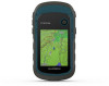
Navigating with the Map NOTICE The maps included on your device can create pedestrian or cycling routes using roads and trails, but not routes for automobile navigation. 1 Begin navigating to a destination. 2 Select Map. represents your location on the map. Your route is marked with a colored line. 3 Complete one or more actions: • Use the Thumb Stick controller to move the cursor on the map to view different areas. • To zoom in and out of the map, select and . Changing the Map Orientation 1 From the map, select menu. 2 Select Setup Map > Orientation. 3 Select an option: • Select North Up to show north at the top of the page. • Select Track Up to show your current direction of travel at the top of the page. • Select Automotive Mode to show an automotive perspective with the direction of travel at the top. Measuring Distance on the Map You can measure the distance between two locations. 1 From the map, select a location. 2 Select menu > Measure Distance. 3 Move the pin to another location on the map. Map Settings Select Setup > Map. Orientation: Adjusts how the map is shown on the page. North Up shows north at the top of the page. Track Up shows a topdown view with your current direction of travel toward the top of the page. Automotive Mode shows an 3D automotive view with the direction of travel at the top. Data Fields: Customizes the data fields and dashboards of the map, compass, elevation plot, and trip computer. Advanced Map Setup: Enables you to open advanced map settings (Map Settings, page 4). Map Information: Enables or disables the maps currently loaded on the device. Advanced Map Settings Select Setup > Map > Advanced Map Setup. Auto Zoom: Automatically selects the appropriate zoom level for optimal use on your map. When Off is selected, you must zoom in or out manually. Zoom Levels: Adjusts the zoom level at which map items will appear. The map items will not appear when the map zoom level is higher than the selected level. Text Size: Selects the text size for map items. Detail: Selects the amount of detail shown on the map. Showing more detail may cause the map to redraw more slowly. Shaded Relief: Shows detail relief on the map (if available) or turns off shading. Compass When navigating, points to your destination, regardless of the direction you are moving. When points toward the top of the electronic compass, you are traveling directly toward your destination. If points any other direction, turn until it points toward the top of the compass. Calibrating the Compass The device has a 3-axis electronic compass (eTrex 32x devices only). You should calibrate the compass after moving long distances, experiencing temperature changes, or changing the batteries. 1 Go outside, away from objects that influence magnetic fields, such as cars, buildings, or overhead power lines. 2 From the compass, select menu. 3 Select Calibrate Compass > Start. 4 Follow the on-screen instructions. Navigating with the Compass When navigating to a destination, points to your destination, regardless of the direction you are moving. 1 Begin navigating to a destination (Navigating to a Destination, page 3). 2 Select Compass. 3 Turn until points toward the top of the compass, and continue moving in that direction to the destination. Course Pointer The course pointer is most useful when you are navigating on water or where there are no major obstacles in your path. It can also help you avoid hazards near the course, such as shoals or submerged rocks. To enable the course pointer, from the compass, select menu > Setup Heading > Go To Line/Pointer > Course (CDI). The course pointer indicates your relationship to the course line leading to the destination. The course deviation indicator (CDI) provides the indication of drift (right or left) from the course. The scale refers to the distance between dots on the course deviation indicator, which tell you how far off course you are. Elevation Plot NOTE: The elevation plot is available only with eTrex 32x devices. By default, the elevation plot displays the elevation over the distance traveled. You can customize elevation plot settings (Elevation Plot Settings, page 4). You can select any point on the plot to view details about that point. Calibrating the Barometric Altimeter You can manually calibrate the barometric altimeter if you know the correct elevation or the correct barometric pressure. 1 Go to a location where the elevation or barometric pressure is known. 2 Select Elevation Plot > menu > Calibrate Altimeter. 3 Follow the on-screen instructions. Elevation Plot Settings From the elevation plot, select menu. Change Plot Type: Sets the type of data shown on the elevation plot. . Adjust Zoom Ranges: Adjusts the zoom ranges shown on the altimeter page. 4 Navigation
-
 1
1 -
2
-
 3
3 -
 4
4 -
 5
5 -
 6
6 -
 7
7 -
 8
8 -
 9
9 -
 10
10 -
 11
11 -
 12
12 -
 13
13 -
14
-
15
-
16
-
17
-
18
 |
 |
