Pioneer AVIC-8100NEX Owner's Manual - Page 55
Viewing the traffic list, Checking the traffic, incidents on the map, Receiving real-time traffic
 |
View all Pioneer AVIC-8100NEX manuals
Add to My Manuals
Save this manual to your list of manuals |
Page 55 highlights
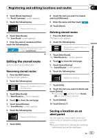
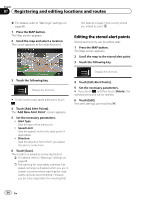
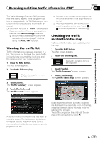
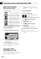
Receiving real-time traffic information (TMC) Chapter 08 The Traffic Message Channel (TMC) provides real-time traffic reports. If the navigation system is equipped with the TMC feature, you can check the traffic reports and information received. p The online function in "Traffic" can be used if you connect an iPhone or a smartphone that has the AVICSYNC App installed. = Be sure read Expanding the use of the navigation functions (page 71) before using the AVICSYNC function. Viewing the traffic list Traffic information is displayed onscreen in a list. This allows you to check how many traffic incidents have occurred, the locations, and the distance from your current position. 1 Press the MAP button. The Map screen appears. 2 Touch the following key. Displays the navigation menu on the Map screen. 3 Touch [Traffic]. The "Traffic Summary" screen appears. 4 Touch [Traffic Events]. The "Traffic Events" screen appears. p If a route is set, relevant events for your current route are shown in the upper section of the list. p Touching the desired item allows you to check its position on the map. Touch or to show the previous or next event. Checking the traffic incidents on the map Traffic event information can be displayed on the map. 1 Press the MAP button. The Map screen appears. 2 Touch the following key. Displays the navigation menu on the Map screen. 3 Touch [Traffic]. The "Traffic Summary" screen appears. 4 Touch [Traffic Map]. The "Current Traffic Map" screen appears. Receiving real-time traffic information (TMC) A list with traffic information that has been received is shown. The list is sorted by distance from your current position. Places (street names) where incidents have occurred are displayed on the list. Road segments affected by traffic incidents are displayed in an alternate color on the map, and small symbols above the road show the nature of the incident. The traffic congestion lines indicate the degree of the congestion by color. En 55
-
 1
1 -
2
-
3
-
4
-
5
-
6
-
7
-
8
-
9
-
10
-
11
-
12
-
13
-
14
-
15
-
16
-
17
-
18
-
19
-
20
-
21
-
22
-
23
-
24
-
25
-
26
-
27
-
28
-
29
-
30
-
31
-
32
-
33
-
34
-
35
-
36
-
37
-
38
-
39
-
40
-
41
-
42
-
43
-
44
-
45
-
46
-
47
-
48
-
49
-
 50
50 -
 51
51 -
 52
52 -
 53
53 -
 54
54 -
 55
55 -
 56
56 -
 57
57 -
 58
58 -
 59
59 -
 60
60 -
61
-
62
-
63
-
64
-
65
-
66
-
67
-
68
-
69
-
70
-
71
-
72
-
73
-
74
-
75
-
76
-
77
-
78
-
79
-
80
-
81
-
82
-
83
-
84
-
85
-
86
-
87
-
88
-
89
-
90
-
91
-
92
-
93
-
94
-
95
-
96
-
97
-
98
-
99
-
100
-
101
-
102
-
103
-
104
-
105
-
106
-
107
-
108
-
109
-
110
-
111
-
112
-
113
-
114
-
115
-
116
-
117
-
118
-
119
-
120
-
121
-
122
-
123
-
124
-
125
-
126
-
127
-
128
-
129
-
130
-
131
-
132
-
133
-
134
-
135
-
136
-
137
-
138
-
139
-
140
-
141
-
142
-
143
-
144
-
145
-
146
-
147
-
148
-
149
-
150
-
151
-
152
-
153
-
154
-
155
-
156
-
157
-
158
-
159
-
160
-
161
-
162
-
163
-
164
-
165
-
166
-
167
-
168
-
169
-
170
-
171
-
172
-
173
-
174
-
175
-
176
-
177
-
178
-
179
-
180
-
181
-
182
-
183
-
184
-
185
-
186
-
187
-
188
-
189
-
190
-
191
-
192
-
193
-
194
-
195
-
196
-
197
-
198
-
199
-
200
-
201
-
202
-
203
-
204
-
205
-
206
-
207
-
208
-
209
-
210
-
211
-
212
-
213
-
214
-
215
-
216
-
217
-
218
-
219
-
220
-
221
-
222
-
223
-
224
-
225
-
226
-
227
-
228
-
229
-
230
-
231
-
232
-
233
-
234
-
235
-
236
-
237
-
238
-
239
-
240
-
241
-
242
-
243
-
244
-
245
-
246
-
247
-
248
-
249
-
250
-
251
-
252
-
253
-
254
-
255
-
256
-
257
-
258
-
259
-
260
-
261
-
262
-
263
-
264
 |
 |
