Pioneer AVIC-88DVD Owner's Manual - Page 27
Changing the scale of the map, Moving the map to the location, you want to see
 |
View all Pioneer AVIC-88DVD manuals
Add to My Manuals
Save this manual to your list of manuals |
Page 27 highlights
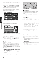
Chapter 1 Basic Operation (9) Current time (10) Estimated time of arrival (or travel time to your destination)* The display changes with each touch. (11) Tracking mark The tracking mark shows the route your vehicle has traveled. ➲ Select the tracking setting ➞ Page 48 (12) Map of your surroundings (Side map) Touching this takes you to the map scroll screen. (13) Distance to an intersection* Displayed on the enlarged intersection map. The green bar gets shorter as your vehicle approaches an intersection. (14) Next direction of travel* (15) Area to Avoid* ➲ About detour area ➞ Page 41 (16) Direction line The direction towards the location set in (4) is indicated with a straight line. ❒ Information with the mark (*) appears only when the route is set. ❒ Depending on the conditions and settings, some items may not be displayed. ❒ POI icon is indicated when the map scale is 0.75 mile (1 km) or lower. ❒ The Direct scale key may not appear depending on the map display mode. Moving the map to the location you want to see If you touch the display briefly, the shortcut menu appears. Touching anywhere on the map for at least 2 seconds changes the map to Scroll mode and the map begins scrolling in the direction you touched. The scrolling stops when you remove your finger from the screen. At this time, the cross pointer appears at the center of the screen. Also a line connecting between the current location and cross pointer appears. Pressing the NAVI (or POS) button returns you to the map of your surroundings. ❒ Touch the area close to the center of the screen to scroll slowly; touch near the sides of the screen to scroll through quickly. (2) (1) Changing the scale of the map Touching the "Map scale" key displayed on the upper right of the screen displays the scale gauge and "Map scale" key. Directly touching the "Map scale" key changes the map to the selected scale. Touching or on the scale gauge allows you to specify the scale in greater detail within a range of 25 yards - 1000 miles (25 meters - 2000 kilometers). Direct scale key ❒ The icon of a registered location is indicated when the map scale is 10 miles (20 km) or lower. (4) (3) (1) Scroll location The position of cross pointer shows the location selected on the current map. (2) Distance from the current location Shows the distance in a straight line between the location indicated by the cross pointer and your current location. (3) The street name, city name, area name and other information for this place. (The case of a map scale of 0.25 mile (200 m) or lower.) Touching the on the right displays hidden text. ➲ Displaying information on the specified loca- tion ➞ Page 26 25
-
 1
1 -
2
-
3
-
4
-
5
-
6
-
7
-
8
-
9
-
10
-
11
-
12
-
13
-
14
-
15
-
16
-
17
-
18
-
19
-
20
-
21
-
 22
22 -
 23
23 -
 24
24 -
 25
25 -
 26
26 -
 27
27 -
 28
28 -
 29
29 -
 30
30 -
 31
31 -
 32
32 -
33
-
34
-
35
-
36
-
37
-
38
-
39
-
40
-
41
-
42
-
43
-
44
-
45
-
46
-
47
-
48
-
49
-
50
-
51
-
52
-
53
-
54
-
55
-
56
-
57
-
58
-
59
-
60
-
61
-
62
-
63
-
64
-
65
-
66
-
67
-
68
-
69
-
70
-
71
-
72
-
73
-
74
 |
 |
