Garmin GDL 88 Series Pilots Guide - Page 31
NEXRAD Abnormalities, NEXRAD Limitations
 |
View all Garmin GDL 88 Series manuals
Add to My Manuals
Save this manual to your list of manuals |
Page 31 highlights
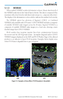
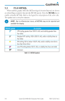
NOTE: FIS-B NEXRAD does not differentiate between frozen and liquid precipitation. The FIS-B NEXRAD intensity colors (as shown) may differ from the intensity colors from other providers. NOTE: FIS-B information including weather information, NOTAMs, and TFR areas, are intended to be used for pilot planning decisions and pilot near-term decisions focused on avoiding areas of inclement weather that are beyond visual range or where poor visibility precludes visual acquisition of inclement weather. The system lacks sufficient resolution and updating capability necessary for aerial maneuvering associated with immediate decisions. 5.1.1 NEXRAD Abnormalities There are possible abnormalities regarding displayed NEXRAD images. Some, but not all, causes of abnormal displayed information include: • Ground Clutter • Strobes and spurious radar data • Sun strobes, when the radar antenna points directly at the sun • Military aircraft deploy metallic dust which can cause alterations in radar scans • Interference from buildings or mountains, which may cause shadows • Scheduled maintenance may put a radar off-line 5.1.2 NEXRAD Limitations Certain limitations exist regarding the NEXRAD radar displays. Some, but not all, are listed for the user's awareness: • The (high resolution) Regional NEXRAD "pixels" are 1.5 minutes (1.5 nautical miles = 2.78 km) wide by 1 minute (1 nautical miles = 1.852 km) tall. • The (medium resolution - 5 times larger than high resolution) CONUS NEXRAD "pixels" are 7.5 minutes (7.5 nautical miles = 13.89 km) wide by 5 minutes (5 nautical miles = 9.26 km) wide. • Above 60 degrees of latitude the block widths double to 3 minutes/nautical miles for Regional (no CONUS above 60 degrees). 190-01122-03 Rev. E Garmin GDL 84/88 ADS-B Transceiver Pilot's Guide 5-3
-
 1
1 -
2
-
3
-
4
-
5
-
6
-
7
-
8
-
9
-
10
-
11
-
12
-
13
-
14
-
15
-
16
-
17
-
18
-
19
-
20
-
21
-
22
-
23
-
24
-
25
-
 26
26 -
 27
27 -
 28
28 -
 29
29 -
 30
30 -
 31
31 -
 32
32 -
 33
33 -
 34
34 -
 35
35 -
 36
36 -
37
-
38
-
39
-
40
-
41
-
42
-
43
-
44
-
45
-
46
-
47
-
48
-
49
-
50
-
51
-
52
 |
 |
