Garmin GDL 88 Series Pilots Guide - Page 33
FIS-B TFRs
 |
View all Garmin GDL 88 Series manuals
Add to My Manuals
Save this manual to your list of manuals |
Page 33 highlights
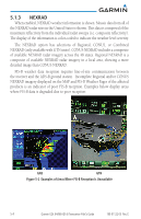
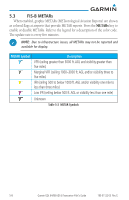
Affected Areas Any area in the continental United States (CONUS) or Alaska where the distance from ADS-B ground stations or the combined effect of distance and low altitude is sufficiently great to cause poor reception. A good source of information for ground station coverage can be found at http://www.faa.gov/. Due to line-of-sight broadcast characteristics, operators with properly installed and functioning equipment may still receive incomplete FIS-B data when signal reception is limited by the distance from ground stations combined with a low altitude. Continental US (CONUS) NEXRAD The Display CONUS NEXRAD selection shows NEXRAD radar information for the entire continental United States. CONUS NEXRAD data is updated every 15 minutes. The resolution of displayed CONUS NEXRAD data is approximately 5.4 NM (10 kilometers). The intensity level reflected by the pixel is the highest level sampled within the area covered by each pixel. Regional NEXRAD The Regional NEXRAD selection shows regional NEXRAD radar information within 250 miles of the aircraft location. Regional NEXRAD data is updated every 5 minutes (10 minutes for clear air mode). Combined NEXRAD Regional NEXRAD data within 500 NM of the aircraft location and CONUS NEXRAD data everywhere else. The two types of NEXRAD are separated by a white stippled border. This boundary is updated whenever new Regional or CONUS NEXRAD data is received. 5.2 FIS-B TFRs Temporary Flight Restrictions (TFRs) provide detailed information for local short term restrictions. The update rate is approximately every 20 minutes. NOTE: Some TFRs may not be shown or information may be incomplete. The presented TFR information is only advisory in nature. Check official sources, such as from preflight planning or Flight Service Station to determine more complete TFR information. 190-01122-03 Rev. E Garmin GDL 84/88 ADS-B Transceiver Pilot's Guide 5-5
-
 1
1 -
2
-
3
-
4
-
5
-
6
-
7
-
8
-
9
-
10
-
11
-
12
-
13
-
14
-
15
-
16
-
17
-
18
-
19
-
20
-
21
-
22
-
23
-
24
-
25
-
26
-
27
-
 28
28 -
 29
29 -
 30
30 -
 31
31 -
 32
32 -
 33
33 -
 34
34 -
 35
35 -
 36
36 -
 37
37 -
 38
38 -
39
-
40
-
41
-
42
-
43
-
44
-
45
-
46
-
47
-
48
-
49
-
50
-
51
-
52
 |
 |
