Garmin GDL 88 Series Pilots Guide - Page 32
Nexrad
 |
View all Garmin GDL 88 Series manuals
Add to My Manuals
Save this manual to your list of manuals |
Page 32 highlights
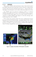
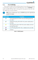
5.1.3 NEXRAD When enabled, NEXRAD weather information is shown. Mosaic data from all of the NEXRAD radar sites in the United States is shown. This data is composed of the maximum reflectivity from the individual radar sweeps (i.e. composite reflectivity). The display of the information is color-coded to indicate the weather level severity. The NEXRAD option has selections of Regional, CONUS, or Combined NEXRAD (only available with GTN units). CONUS NEXRAD includes a composite of available NEXRAD radar imagery across the 48 states. Regional NEXRAD is a composite of available NEXRAD radar imagery in a local area, showing a more detailed image than CONUS NEXRAD. FIS-B weather data reception requires line-of-site communication between the receiver and the ADS-B ground station. Incomplete Regional and/or CONUS NEXRAD imagery displayed on the MAP and FIS-B Weather Pages of the affected products is an indicator of poor FIS-B reception. Examples below display areas where FIS-B data is degraded due to poor reception: GNS GTN Figure 5-2 Examples of Areas Where FIS-B Reception Is Unavailable 5-4 Garmin GDL 84/88 ADS-B Transceiver Pilot's Guide 190-01122-03 Rev. E
-
 1
1 -
2
-
3
-
4
-
5
-
6
-
7
-
8
-
9
-
10
-
11
-
12
-
13
-
14
-
15
-
16
-
17
-
18
-
19
-
20
-
21
-
22
-
23
-
24
-
25
-
26
-
 27
27 -
 28
28 -
 29
29 -
 30
30 -
 31
31 -
 32
32 -
 33
33 -
 34
34 -
 35
35 -
 36
36 -
 37
37 -
38
-
39
-
40
-
41
-
42
-
43
-
44
-
45
-
46
-
47
-
48
-
49
-
50
-
51
-
52
 |
 |
