Garmin GPSMAP 527 Weather Supplement - Page 8
Hurricane Information, Weather Warnings and Weather Bulletins, See the Appendix
 |
View all Garmin GPSMAP 527 manuals
Add to My Manuals
Save this manual to your list of manuals |
Page 8 highlights
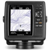
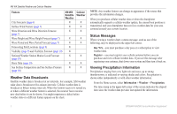
XM WX Satellite Weather and Cellular Weather Lightning strikes are represented by lightning bolt icons ➌. Lightning appears on the weather Precipitation chart if strikes were detected within the last seven minutes. The ground-based lightning detection network detects cloud-to-ground lightning only. Hurricane Information The weather Precipitation chart can show the present position of a hurricane ➊, a tropical storm, or a tropical depression. A red line stemming from a hurricane icon indicates the projected path ➋ of the hurricane. Darkened dots on the red line indicate the projected locations through which the hurricane will pass, as received from the weather data provider. Weather Warnings and Weather Bulletins When a marine weather warning, weather watch, weather advisory, weather bulletin, or other weather statement is issued, shading ➊ indicates the area to which the information applies. To view information about the warning or bulletin, select the shaded area. The aqua lines ➋ on the chart indicate the boundaries of marine forecasts, coastal forecasts, and offshore forecasts. Weather bulletins may consist of either weather watches or weather advisories. See the Appendix (page 19) to view a list of color shading descriptions. ➋ ➊ ➋ ➊ 4 GPSMAP 400/500 Series Weather Supplement
-
 1
1 -
2
-
 3
3 -
 4
4 -
 5
5 -
 6
6 -
 7
7 -
 8
8 -
 9
9 -
 10
10 -
 11
11 -
 12
12 -
 13
13 -
14
-
15
-
16
-
17
-
18
-
19
-
20
-
21
-
22
-
23
-
24
-
25
-
26
-
27
-
28
 |
 |
