Alpine INE-Z928HD Navigation User's Manual (english) - Page 71
calculation INE-Z928HD/INE-NAV-38 Only. - measurements
 |
View all Alpine INE-Z928HD manuals
Add to My Manuals
Save this manual to your list of manuals |
Page 71 highlights
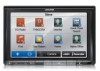
The recommended route is not always the same between two points. Whenever suitable data exists, traffic information can be taken into account in the route calculation (INE-Z928HD/INE-NAV-38 Only). These settings determine how routes will be calculated. Select the type of vehicle you are driving, the road types used in route planning, and the route planning method. You can fine-tune the appearance of the Map screen. Adjust the map view to your needs, choose suitable color themes from the list for both daytime and night use, change the blue arrow to a 3D car model, show or suppress 3D buildings, turn track logging on or off, and manage you Place visibility sets (which Places to show on the map). Adjust how the software helps you navigate with different kinds of route related information on the Map screen. These settings allow you to customize the application for your local language, measurement units, time and date settings and formats, as well as to choose the time zone. Trip logs and track logs contain useful information about your trips. Trip logs can be saved manually when you reach your destination or you can turn on the automatic saving here. Modify the basic software parameters set during the initial setup process. For details, see page 7. Delete all saved data and reset all settings to their factory defaults. Visit alpine.naviextras.com to get additional content, such as new maps or 3D landmarks and useful applications. The About section provides you with product information. Read the Software and Database End User License Agreement, or check the map and other contents of the application. You can also access program usage statistics. 71
-
 1
1 -
2
-
3
-
4
-
5
-
6
-
7
-
8
-
9
-
10
-
11
-
12
-
13
-
14
-
15
-
16
-
17
-
18
-
19
-
20
-
21
-
22
-
23
-
24
-
25
-
26
-
27
-
28
-
29
-
30
-
31
-
32
-
33
-
34
-
35
-
36
-
37
-
38
-
39
-
40
-
41
-
42
-
43
-
44
-
45
-
46
-
47
-
48
-
49
-
50
-
51
-
52
-
53
-
54
-
55
-
56
-
57
-
58
-
59
-
60
-
61
-
62
-
63
-
64
-
65
-
 66
66 -
 67
67 -
 68
68 -
 69
69 -
 70
70 -
 71
71 -
 72
72 -
 73
73 -
 74
74 -
 75
75 -
 76
76 -
77
-
78
-
79
-
80
-
81
-
82
-
83
-
84
-
85
 |
 |