Garmin GPSMAP 620 Owner's Manual - Page 44
Cruising, Data Bar Setup, Navigation, Fishing, Sailing, Chart Appearance, Orientation, North Up
 |
UPC - 749856016963
View all Garmin GPSMAP 620 manuals
Add to My Manuals
Save this manual to your list of manuals |
Page 44 highlights
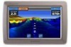
Marine Mode: Advanced Configuration Choose to show or hide the numbers by category. When set to Auto, the overlay numbers appear only when that category is active. • Cruising: GPS speed and GPS heading. ◦ Data Bar Setup-specify the position of the data bar on the Navigation chart, and specify the contents of the fields. • Navigation: GPS speed, distance to destination, arrival (time), off course, bearing (to destination), and GPS heading. When set to Auto, these numbers appear only when navigating to a destination. ◦ Data Bar Setup-toggle the Route Leg data field (shows additional route information) and specify how each data field provides navigation information (by time or by distance). • Fishing: Depth, water temperature, and water speed. Depth, temperature, and water speed are only available when connected to a sonar unit. • Sailing: Water speed, wind speed, wind angle, and Wind Velocity Made Good (VMG). Wind speed, angle and VMG are only available when connected to an optional NMEA 0183 wind sensor. 38 ◦ Wind-choose the type of wind data used in the sailing data fields (apparent or true). Chart Appearance-customize the appearance of the Navigation chart. • Orientation-changes the perspective of the map display: ◦ North Up-set the top of the map display to a north heading. ◦ Head Up-set the top of the map display according to your heading. The heading line appears vertically on the screen if it is shown. ◦ Course Up-set the map so the direction of navigation is always up. • Detail-adjust the amount of detail shown on the map. • Heading Line-draws an extension from the bow of the boat in the direction of travel. ◦ Off-turn off the heading line. ◦ Distance-set the distance to the end of the heading line. ◦ Time-set the amount of time until you reach the end of the heading line. • World Map-toggle between a basic worldmap and a full worldmap, or basemap. The basic worldmap shows costal outlines of the world, with land indicated in yellow. The full GPSMAP 620 Owner's Manual
-
 1
1 -
2
-
3
-
4
-
5
-
6
-
7
-
8
-
9
-
10
-
11
-
12
-
13
-
14
-
15
-
16
-
17
-
18
-
19
-
20
-
21
-
22
-
23
-
24
-
25
-
26
-
27
-
28
-
29
-
30
-
31
-
32
-
33
-
34
-
35
-
36
-
37
-
38
-
 39
39 -
 40
40 -
 41
41 -
 42
42 -
 43
43 -
 44
44 -
 45
45 -
 46
46 -
 47
47 -
 48
48 -
 49
49 -
50
-
51
-
52
-
53
-
54
-
55
-
56
-
57
-
58
-
59
-
60
-
61
-
62
-
63
-
64
-
65
-
66
-
67
-
68
-
69
-
70
-
71
-
72
 |
 |
