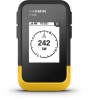
Garmin eTrex SE Owners Manual - Page 22
Time Settings, Compass Settings, Position Format Settings
 |
View all Garmin eTrex SE manuals
Add to My Manuals
Save this manual to your list of manuals |
Page 22 highlights
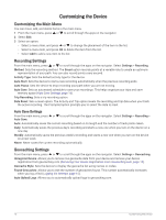
Course Trns. Dist.: Sets how far between course points when the navigator transitions to next point in the course, when Distance is selected for the Course Trans. settings. USB Mode: Sets the device to use MTP (media transfer protocol) or Garmin® mode when connected to a computer. Reset: Allows you to reset user data and settings (Resetting Data and Settings, page 19). Time Settings From the main menu, press or to scroll through the apps on the navigator. Select Settings > System > Time. Time Format: Sets the device to show time in a 12-hour or 24-hour format. Time Zone: Sets the time zone for the device. The Automatic option sets the time zone automatically based on your GPS position. Daylight Saving: Sets the device to use daylight saving time. Compass Settings From the main menu, press or to scroll through the apps on the navigator. Select Settings > System > Compass. Display: Sets the directional heading on the compass to letters, degrees, or milliradians. North Reference: Sets the north reference used on the compass (Setting the North Reference, page 6). Pointer: Sets the behavior of the pointer that appears on the map. Bearing points in the direction of your destination. Course (CDI) shows your relationship to the course line leading to the destination. Compass: Automatically switches from an electronic compass to a GPS compass when you are traveling at a higher rate of speed for a period of time. Calibrate: Allows you to calibrate the compass if you experience irregular compass behavior. For example, after moving long distances or after extreme temperature changes (Calibrating the Compass, page 6). Dashboard: Sets a dashboard to display on the compass. Each dashboard shows different information about your course or your location. Position Format Settings NOTE: You should not change the position format or the map datum coordinate system unless you are using a map or chart that specifies a different position format. From the main menu, press or to scroll through the apps on the navigator. Select Settings > System > Position Format. Format: Sets the position format in which a location reading appears. Datum: Sets the coordinate system on which the map is structured. Spheroid: Shows the coordinate system the device is using. The default coordinate system is WGS 84. 18 Customizing the Device
-
 1
1 -
2
-
3
-
4
-
5
-
6
-
7
-
8
-
9
-
10
-
11
-
12
-
13
-
14
-
15
-
16
-
 17
17 -
 18
18 -
 19
19 -
 20
20 -
 21
21 -
 22
22 -
 23
23 -
 24
24 -
 25
25 -
 26
26 -
 27
27 -
28
-
29
-
30
 |
 |
