Magellan GPS 315 User Manual - Page 75
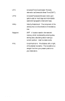
Man Over Board MOB
 |
UPC - 763357101522
View all Magellan GPS 315 manuals
Add to My Manuals
Save this manual to your list of manuals |
Page 75 highlights
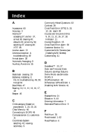
G Glossary 61 GOTO clearing 28; creating 28, in the plotter screen 28 GPS fix alarm 40 H Hide Data/Show Data 16 I Initializing 4, 41 Multi-Leg route, creating 30 N Navigation screens 7; Compass 11; disabling 41; Nav 1 10; Nav 2 12; Plot 13; Position 9; Road 17; Speed 18; Status 8; Time 20 Nav Units 44 NiCad batteries 50 NMEA 46; Data Messages 52-57 NorthFinder™ 11 North Reference 44 K Keys 2 O Odometer 18; resetting 18 L Landmark (LMK) 5 Lanyard strap instructions 60 LAT/LON 42; troubleshooting 49 Light Timer 45 M Magnetic North 44 Man Over Board (MOB) clearing 29; creating 29 Map Datums available datums 58; selecting 43 Map 'N Track Route 34 Memory clear 46 Message accessing 37; viewing 37 Modes of operation see Simulate mode; see 2D, 3D P PAN-N-SCAN 14 Personalize 45 Plot Rings 15 Plot Scales 16 Plot screen 13 Plotter 15 Population of cities 24 Position fix 6; troubleshooting 49 Position screen 9 Power On 4 Primary Usage 5 Projecting a Waypoint 25 Proximity alarm 39 R Receiver size 59 Reception 4 Road screen 17; customize 17 Magellan GPS 315/ GPS 320 67
-
 1
1 -
2
-
3
-
4
-
5
-
6
-
7
-
8
-
9
-
10
-
11
-
12
-
13
-
14
-
15
-
16
-
17
-
18
-
19
-
20
-
21
-
22
-
23
-
24
-
25
-
26
-
27
-
28
-
29
-
30
-
31
-
32
-
33
-
34
-
35
-
36
-
37
-
38
-
39
-
40
-
41
-
42
-
43
-
44
-
45
-
46
-
47
-
48
-
49
-
50
-
51
-
52
-
53
-
54
-
55
-
56
-
57
-
58
-
59
-
60
-
61
-
62
-
63
-
64
-
65
-
66
-
67
-
68
-
69
-
 70
70 -
 71
71 -
 72
72 -
 73
73 -
 74
74 -
 75
75 -
 76
76 -
 77
77 -
 78
78
 |
 |
