Magellan Mapsend Direct Route Manual - English, French, German and Spanish - Page 19
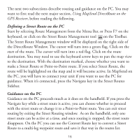
Using DirectRoute on the GPS Receiver, Viewing the Detailed Map, About Street Routing and Guidance
 |
UPC - 763357108514
View all Magellan Mapsend Direct Route manuals
Add to My Manuals
Save this manual to your list of manuals |
Page 19 highlights
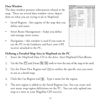
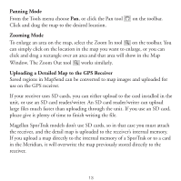
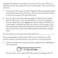
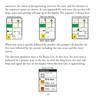
Using DirectRoute on the GPS Receiver Viewing the Detailed Map There are two ways to quickly view a DirectRoute map on the handheld. 1. Press the NAV or ESC key until you reach the Map screen. Use the cursor key and the Zoom keys to find the general area of the detailed map. You will see a rectangle indicating the area of the detailed map. Zoom in to at least a scale of 0.40 mi. (700 m) to view the detailed map. 2. Press the Menu key and select "Database". Select the detailed map, by its name, from the list of options. Now you can search POIs in the detailed map. Find a POI you want to see, press VIEW, and the POI in the detailed map will appear. About Street Routing and Guidance DirectRoute is the first MapSend product with the ability to automatically calculate a street route and use it for turn-by-turn guidance. DirectRoute calculates shortest time street routes. Shortest time street route calculation considers the speed limits and length of possible street paths between you and your destination. The shortest time route is not necessarily the fastest or simplest route. DirectRoute is tuned to provide reasonable street routes, but it doesn't know about traffic, road construction, etc. DirectRoute also maintains the ability to manually set up simple, straight-line pointto-point routes and multi-leg Waypoint Routes, similar to other Magellan MapSend products. This Quick Start guide focuses on street routing. There is more information about straight-line routing in the User Manual for your GPS receiver. 17
-
 1
1 -
2
-
3
-
4
-
5
-
6
-
7
-
8
-
9
-
10
-
11
-
12
-
13
-
 14
14 -
 15
15 -
 16
16 -
 17
17 -
 18
18 -
 19
19 -
 20
20 -
 21
21 -
 22
22 -
 23
23 -
 24
24 -
25
-
26
-
27
-
28
-
29
-
30
-
31
-
32
-
33
-
34
-
35
-
36
-
37
-
38
-
39
-
40
-
41
-
42
-
43
-
44
-
45
-
46
-
47
-
48
-
49
-
50
-
51
-
52
-
53
-
54
-
55
-
56
-
57
-
58
-
59
-
60
-
61
-
62
-
63
-
64
-
65
-
66
-
67
-
68
-
69
-
70
-
71
-
72
-
73
-
74
-
75
-
76
-
77
-
78
-
79
-
80
-
81
-
82
-
83
-
84
-
85
-
86
-
87
-
88
-
89
-
90
-
91
-
92
-
93
-
94
-
95
-
96
-
97
-
98
-
99
-
100
-
101
-
102
-
103
-
104
-
105
-
106
-
107
-
108
 |
 |