Meade 12 inch Instruction Manual - Page 29
Vicinity of Polaris
 |
View all Meade 12 inch manuals
Add to My Manuals
Save this manual to your list of manuals |
Page 29 highlights
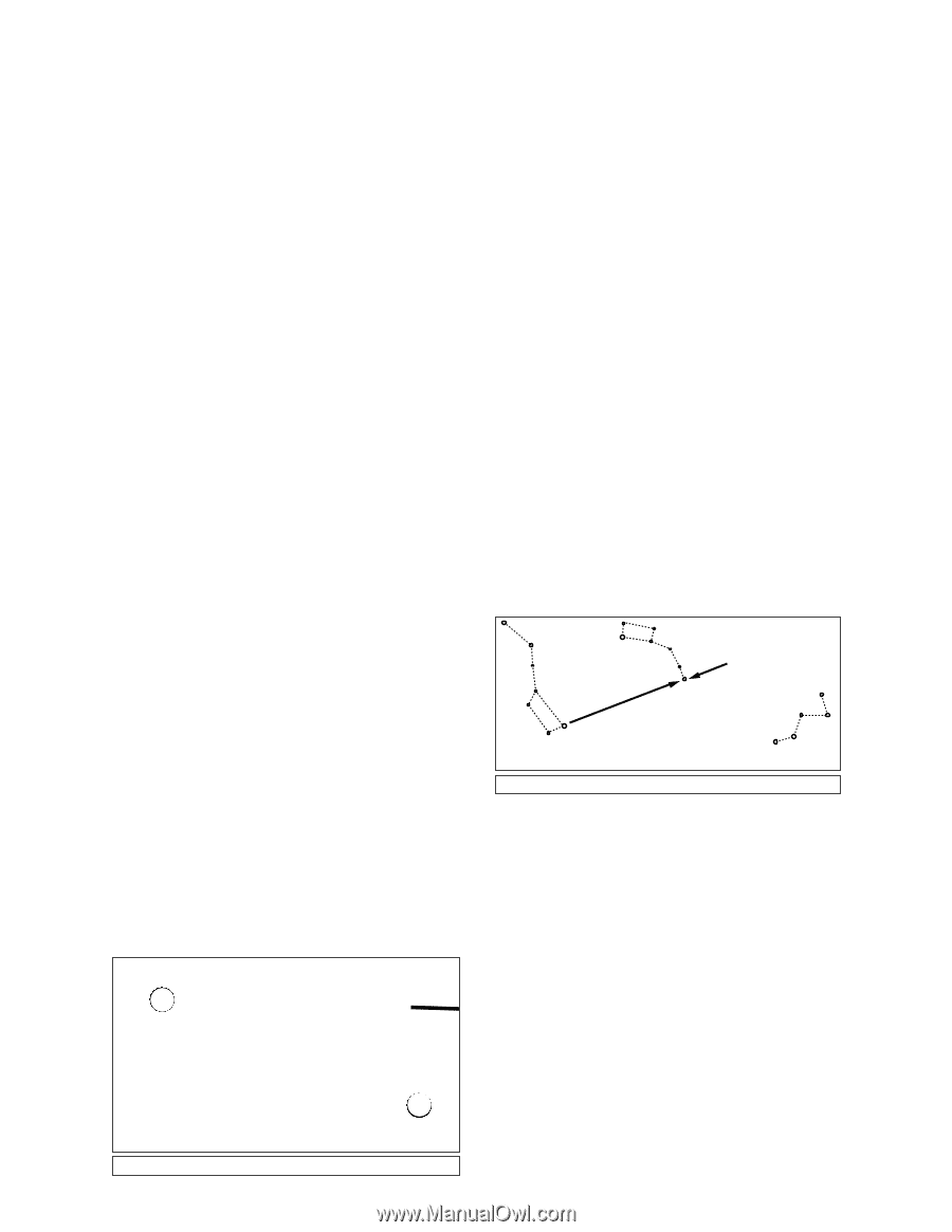
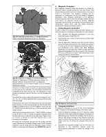
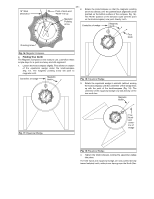
- 29 - APPENDIX B: EQUATORIAL USE effect, to read the object coordinates and the object found 1. Celestial Coordinates without resorting to visual location techniques. However, these setting circles may be used to advantage only if the telescope Celestial objects are mapped according to a coordinate system is first properly aligned with the North Celestial Pole. on the Celestial Sphere, an imaginary sphere surrounding Earth on which all stars appear to be placed. This celestial 2. Lining Up with the Celestial Pole object mapping system is analogous to the Earth-based Objects in the sky appear to revolve around the celestial pole. coordinate system of latitude and longitude. (Actually, celestial objects are essentially "fixed," and their The poles of the celestial coordinate system are defined as apparent motion is caused by the Earth's axial rotation). During those two points where the Earth's rotational axis, if extended any 24 hour period, stars make one complete revolution about to infinity, north and south, intersect the celestial sphere. Thus, the pole, making concentric circles with the pole at the center. the North Celestial Pole (1, Fig. 20) is that point in the sky By lining up the telescope's polar axis with the North Celestial where an extension of the Earth's axis through the North Pole Pole (or for observers located in Earth's Southern Hemisphere intersects the celestial sphere. This point in the sky is located with the South Celestial Pole (see MODE FUNCTIONS, page 16) near the North Star, Polaris. astronomical objects may be followed, or tracked, simply by In mapping the surface of the Earth, lines of longitude are drawn between the North and South Poles. Similarly, lines of latitude are drawn in an east-west direction, parallel to the Earth's Equator. The Celestial Equator (2, Fig. 20) is a moving the telescope about one axis, the polar axis. In the case of the Meade LX200 7", 8", 10", and 12" Schmidt-Cassegrain telescopes, this tracking may be accomplished automatically with the electric motor drive. projection of the Earth's Equator onto the celestial sphere. If the telescope is reasonably well aligned with the pole, Just as on the surface of the Earth, in mapping the celestial sphere, imaginary lines have been drawn to form a coordinate grid. Thus, object positions on the Earth's surface are specified by their latitude and longitude. For example, you could locate Los Angeles, California, by its latitude (+34°) and longitude (118°); similarly, you could locate the constellation Ursa Major (which includes the Big Dipper) by its general position on the celestial sphere: R.A.: 11hr; Dec: +50°. therefore, very little use of the telescope's Declination slow motion control is necessary-virtually all of the required telescope tracking will be in Right Ascension. (If the telescope were perfectly aligned with the pole, no Declination tracking of stellar objects would be required). For the purposes of casual visual telescopic observations, lining up the telescope's polar axis to within a degree or two of the pole is more than sufficient: with this level of pointing accuracy, the telescope's motor drive will track accurately and keep objects in the telescopic field of view for perhaps 20 to 30 minutes. • Right Ascension: The celestial analog to Earth longitude is called "Right Ascension," or "R.A.," and is measured in time on the 24 hour "clock" and shown in hours ("hr"), minutes ("min") and seconds ("sec") from an arbitrarily defined "zero" line of Right Ascension passing through the constellation Pegasus. Right Ascension coordinates range Begin polar aligning the telescope as soon as you can see Polaris. Finding Polaris is simple. Most people recognize the "Big Dipper." The Big Dipper has two stars that point the way to Polaris (see Fig. 21). Once Polaris is found, it is a straightforward procedure to obtain a rough polar alignment. from 0hr 0min 0sec to 23hr 59min 59sec. Thus there are 24 primary lines of R.A., located at 15 degree intervals along the celestial equator. Objects located further and further east of the prime Right Ascension grid line (0hr Little Dipper Polaris 0min 0sec) carry increasing R.A. coordinates. • Declination: The celestial analog to Earth latitude is called Declination, or "Dec", and is measured in degrees, minutes and seconds (e.g., 15° 27' 33"). Declination shown as north of the celestial equator is indicated with a "+" sign in front of the measurement (e.g., the Declination of the North Celestial Pole is +90°), with Declination south of the celestial equator indicated with a "-" sign (e.g., the Declination of the South Celestial Pole is -90°). Any point on the celestial equator itself (which, for example, passes through the constellations Orion, Virgo and Aquarius) is specified as having a Dec of zero, shown as 0° 0' 0". With all celestial objects therefore capable of being specified in position by their celestial coordinates of Right Ascension and Declination, the task of finding objects (in particular, faint objects) is vastly simplified. The setting circles, R.A (10, Fig. 1) and Dec. (3, Fig. 1) of the LX200 telescope may be dialed, in N1orth Celestial Pole (Vicinity of Polaris) Big Dipper Cassiopeia Fig. 21: Locating Polaris. To line up the 7", 8", 10" or 12" LX200 with the Pole, follow this procedure: a. Using the bubble level located on the floor of the wedge, adjust the tripod legs so that the telescope/ wedge/tripod system reads "level." b. Set the equatorial wedge to your observing latitude as described in Appendix A. c. Loosen the Dec. lock, and rotate the telescope tube in Declination so that the telescope's Declination reads 90°. Tighten the Dec. lock. Loosen the R.A. lock, and rotate the Fork Arms to the 00 H.A. position (see MODE FUNCTIONS, page 16) and initiate the POLAR align sequence on the keypad. d. Using the azimuth and latitude controls on the wedge, center Polaris in the field of view. Do not use the telescope's Declination or Right Ascension controls during this process. Fig. 20: The Celestial Sphere. 2 At this point, your polar alignment is good enough for casual observations. There are times, however, when you will need to have precise polar alignment, such as when making fine astrophotographs or when using the setting circles to find new objects.
-
 1
1 -
2
-
3
-
4
-
5
-
6
-
7
-
8
-
9
-
10
-
11
-
12
-
13
-
14
-
15
-
16
-
17
-
18
-
19
-
20
-
21
-
22
-
23
-
 24
24 -
 25
25 -
 26
26 -
 27
27 -
 28
28 -
 29
29 -
 30
30 -
 31
31 -
 32
32 -
 33
33 -
 34
34 -
35
-
36
-
37
-
38
-
39
-
40
-
41
-
42
-
43
-
44
-
45
-
46
-
47
-
48
-
49
-
50
-
51
-
52
-
53
-
54
-
55
-
56
-
57
-
58
-
59
-
60
-
61
-
62
-
63
-
64
 |
 |