Nextar S3 S3 Software Manual - v2 - Page 26
Units of Measure, Time Settings, Map Settings
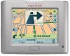 |
UPC - 714129921541
View all Nextar S3 manuals
Add to My Manuals
Save this manual to your list of manuals |
Page 26 highlights
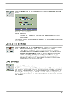
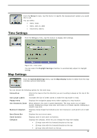
Units of Measure From the Setup 1 menu, tap this button to specify the measurement system you would like to use. You can select: • Miles, Yards • Miles, 10th of a Mile • Kilometers, Meters Time Settings From the Setup 1 menu, tap this button to display time settings. Figure 26 - Time Zone You can select the Daylight Savings checkbox to automatically adjust for daylight savings. Map Settings From the Options&Settings menu, tap the Map Display button to select from the map interface options listed below. You can choose the following options for the main map: Forward up Use Larger Labels Popup menu Use Automatic Zoom Maneuver diagram Next Street Bar Zoom buttons Compass Orients the map so that the direction you are traveling is always at the top of the screen. Increases the size of street names to make the map easier to read. Displays the navigation popup menu when tapping on a map location. When selected, the zoom is speed dependent. The map zooms out at higher speeds, displaying a larger map area, and zooms in at slower speeds, displaying a smaller map area. Displays a large image that indicates your next maneuver, such as left turn or right exit. Displays the next street name. Displays zoom in and zoom out buttons. Displays the compass, which lets you change the map view display: • 2D map view with the forward direction at the top • 3D map view with the forward direction at the top • 2D map view with North at the top 25
-
 1
1 -
2
-
3
-
4
-
5
-
6
-
7
-
8
-
9
-
10
-
11
-
12
-
13
-
14
-
15
-
16
-
17
-
18
-
19
-
20
-
 21
21 -
 22
22 -
 23
23 -
 24
24 -
 25
25 -
 26
26 -
 27
27 -
 28
28 -
 29
29
 |
 |
