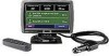
Garmin StreetPilot 7200 Owner's Manual for European Units - Page 51
Changing the Map Settings, Turning Safe Mode Off and On, Changing the Coordinates Settings
 |
UPC - 753759047993
View all Garmin StreetPilot 7200 manuals
Add to My Manuals
Save this manual to your list of manuals |
Page 51 highlights
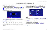
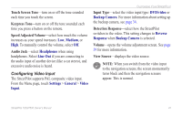
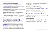
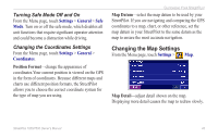
Turning Safe Mode Off and On From the Menu page, touch Settings > General > Safe Mode. Turn on or off the safe mode, which disables all unit functions that require significant operator attention and could become a distraction while driving. Changing the Coordinates Settings From the Menu page, touch Settings > General > Coordinates. Position Format-change the appearance of coordinates.Your current position is viewed on the GPS in the form of coordinates. Because different maps and charts use different position formats, the StreetPilot allows you to choose the correct coordinate system for the type of map you are using. Customizing Your StreetPilot Map Datum-select the map datum to be used by your StreetPilot. If you are navigating and comparing the GPS coordinates to a map, chart, or other reference, set the map datum in your StreetPilot to the same datum as the map to ensure the most accurate navigation. Changing the Map Settings From the Menu page, touch Settings > Map. Map Detail-adjust detail shown on the map. Displaying more detail causes the map to redraw slowly. StreetPilot 7200/7500 Owner's Manual 43
-
 1
1 -
2
-
3
-
4
-
5
-
6
-
7
-
8
-
9
-
10
-
11
-
12
-
13
-
14
-
15
-
16
-
17
-
18
-
19
-
20
-
21
-
22
-
23
-
24
-
25
-
26
-
27
-
28
-
29
-
30
-
31
-
32
-
33
-
34
-
35
-
36
-
37
-
38
-
39
-
40
-
41
-
42
-
43
-
44
-
45
-
 46
46 -
 47
47 -
 48
48 -
 49
49 -
 50
50 -
 51
51 -
 52
52 -
 53
53 -
 54
54 -
 55
55 -
 56
56 -
57
-
58
-
59
-
60
-
61
-
62
-
63
-
64
-
65
-
66
-
67
-
68
-
69
-
70
-
71
-
72
-
73
-
74
 |
 |