Magellan SporTrak User Manual - Page 25
Using the Plot Screen - map how to use
 |
UPC - 763357103717
View all Magellan SporTrak manuals
Add to My Manuals
Save this manual to your list of manuals |
Page 25 highlights
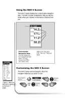
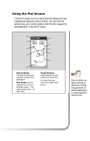
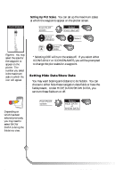
Using the Plot Screen The PLOT screen is a mini map that shows where you have traveled and where you want to travel. You can view the active route, your current position and the other waypoints and destination in the PLOT screen. Destination Name Bearing to Destination Destination Icon Active Route Plot Scale TO: FISH BRG DST 351°m 3.52mI FISH N FISH 2 DOCK BUOY HOME 2.0 m I Distance to Destination North Indicator Waypoint Icon Current Position Icon Track History Active Route Indicates the direction required to reach your destination. Plot Scale Can be changed by using the left/right arrows. The scale ranges from .1 to 200 miles. Track History Automatically records where you have been. The SporTrak can store up to 2000 track points. PAN-N-SCAN, an additional feature, allows you to scroll through the PLOT screen enabling you to create waypoints and GOTOs. Magellan SporTrak 17
-
 1
1 -
2
-
3
-
4
-
5
-
6
-
7
-
8
-
9
-
10
-
11
-
12
-
13
-
14
-
15
-
16
-
17
-
18
-
19
-
 20
20 -
 21
21 -
 22
22 -
 23
23 -
 24
24 -
 25
25 -
 26
26 -
 27
27 -
 28
28 -
 29
29 -
 30
30 -
31
-
32
-
33
-
34
-
35
-
36
-
37
-
38
-
39
-
40
-
41
-
42
-
43
-
44
-
45
-
46
-
47
-
48
-
49
-
50
-
51
-
52
-
53
-
54
-
55
-
56
-
57
-
58
-
59
-
60
-
61
-
62
-
63
-
64
-
65
-
66
-
67
-
68
-
69
-
70
-
71
-
72
-
73
-
74
 |
 |
