Magellan SporTrak User Manual - Page 55
Selecting Map Datum, Selecting Elevation Mode
 |
UPC - 763357103717
View all Magellan SporTrak manuals
Add to My Manuals
Save this manual to your list of manuals |
Page 55 highlights
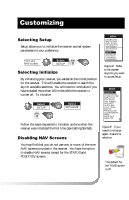
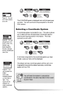
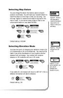
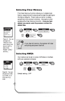
Selecting Map Datum You can change the datum the receiver uses to compute position coordinates. You will want your receiver's datum to match the datum on the map or chart you are using. Use the map "legend" to determine the datum required for the map or chart. If you are not using a map or chart or are unsure which datum to use, select WGS84. Select SETUP Select MAP DATUM FIG. Select primary D or secondary Select datum WMAPPT DNATMUEMS OPRFIFMARY OSENCONDARY Figure D. Be sure the map datum matches the datum required for the maps or charts you are using. Default setting: WGS84 Selecting Elevation Mode You have the option of changing your elevation mode to 2D (2-Dimensional) or 3D (3-Dimensional). You may find 2D useful if you know the elevation of your position and the elevation will not change. Your receiver will compute elevation in 3D mode but will not in 2D mode. Select SETUP Select ELEV MODE FIG. Select E 3D or 2D If you select 3D, the receiver will return to SETUP. If 2D is selected, the receiver will ask for elevation. WELPETVNMAOMDEES O3FDF O2ND Figure E. You can choose from 2D or 3D. WELPETVNAATMIOENS OFF 0000FT ON Figure F. If you are at sea level, you can use 2D because your elevation is zero. FIG. Input F elevation Default setting: 3D Magellan SporTrak 47
-
 1
1 -
2
-
3
-
4
-
5
-
6
-
7
-
8
-
9
-
10
-
11
-
12
-
13
-
14
-
15
-
16
-
17
-
18
-
19
-
20
-
21
-
22
-
23
-
24
-
25
-
26
-
27
-
28
-
29
-
30
-
31
-
32
-
33
-
34
-
35
-
36
-
37
-
38
-
39
-
40
-
41
-
42
-
43
-
44
-
45
-
46
-
47
-
48
-
49
-
 50
50 -
 51
51 -
 52
52 -
 53
53 -
 54
54 -
 55
55 -
 56
56 -
 57
57 -
 58
58 -
 59
59 -
 60
60 -
61
-
62
-
63
-
64
-
65
-
66
-
67
-
68
-
69
-
70
-
71
-
72
-
73
-
74
 |
 |
