Magellan SporTrak User Manual - Page 39
DataSend™ CD, Using DataSend™ - software
 |
UPC - 763357103717
View all Magellan SporTrak manuals
Add to My Manuals
Save this manual to your list of manuals |
Page 39 highlights
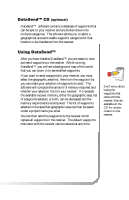
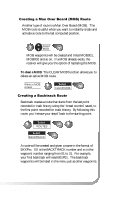
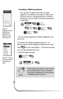
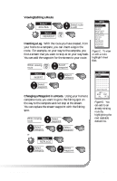
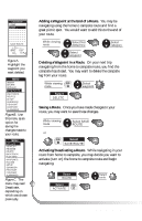
DataSend™ CD (optional) DataSend™ software contains a database of waypoints that can be sent to your receiver and are broken down into multiple categories. The software allows you to select a geographical area and enable waypoint categories for that location to be transferred into the receiver. Using DataSend™ After you have installed DataSend™ you are ready to view and send waypoints to the receiver. While running DataSend™ you will see a background map of the world that you can zoom in to see enabled waypoints. If you want to send waypoints to your receiver, you must select the geographic area first, then from the waypoint list you can make your selection of waypoints to send. The software will compute the amount of memory required and whether your selection fits into your receiver. If it exceeds the available receiver memory, either the geographic area, list of waypoints selected, or both, can be decreased and the memory requirements recomputed. The list of waypoints selected in the specified geographic area can then be saved under a project name you enter. You can then send the waypoints to the receiver which replace all waypoints in the receiver. The default waypoints that came with the receiver can be restored at any time. Don't worry about losing the waypoints that came with the receiver, they are available on the CD for retransmission to the receiver. Magellan SporTrak 31
-
 1
1 -
2
-
3
-
4
-
5
-
6
-
7
-
8
-
9
-
10
-
11
-
12
-
13
-
14
-
15
-
16
-
17
-
18
-
19
-
20
-
21
-
22
-
23
-
24
-
25
-
26
-
27
-
28
-
29
-
30
-
31
-
32
-
33
-
 34
34 -
 35
35 -
 36
36 -
 37
37 -
 38
38 -
 39
39 -
 40
40 -
 41
41 -
 42
42 -
 43
43 -
 44
44 -
45
-
46
-
47
-
48
-
49
-
50
-
51
-
52
-
53
-
54
-
55
-
56
-
57
-
58
-
59
-
60
-
61
-
62
-
63
-
64
-
65
-
66
-
67
-
68
-
69
-
70
-
71
-
72
-
73
-
74
 |
 |
