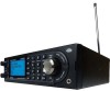
Uniden BCD996P2 English Manual - Page 70
Gps Review Location Mode
 |
View all Uniden BCD996P2 manuals
Add to My Manuals
Save this manual to your list of manuals |
Page 70 highlights
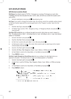
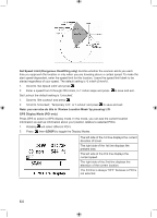
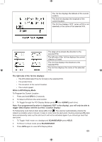
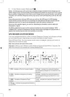
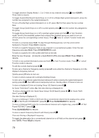
4. To View 'Review Location' Mode press E/ . Notes: All sites/groups (with quick keys enabled and gps enabled for the site/group) not within range of your current location will be temporarily locked out. If you try to use a quick key to enable a site/group for scan that is out of range of your current location, you will see 'Location L/O' and then site/group name (only once), and it will temporary lock out the site/ group. If you disconnect/turn off your GPS unit, you will see 'No GPS Input' in GPS display mode and the scanner will return to scanning any sites/groups that the scanner did not temporary lock out. To restore all sites/groups, cycle the scanner off then on. If you lose the satellite signal, you will see 'Searching for Satellite' until the GPS unit reacquires a signal. If a GPS is detected as soon as the scanner is turned on, the scanner displays "GPS CONNECTED" instead of displaying individual lock/unlock messages for groups/sites. It applies the location-based rules to all systems at one time. GPS REVIEW LOCATION MODE If you have programmed data for a Point of Interest, Dangerous Crossing, and a Dangerous Road, you can review the type, range setting, and location information for each location. Press GPS then E/Yes. The most recently stored location is displayed. Use the scroll control to display the next screen for review. Note: the scanner will mute in this mode. Important: while you are in Review Location Mode and press and hold GPS for 2 seconds, the data of the new point will overwrite the currently displayed data. 1. POI - Indicates a Point of Interest location. 5. Head - Indicates the selected heading to the designated Dangerous Crossing from any direction. 2. DXG - Indicates a Dangerous Crossing location. 6. Head - Indicates the selected heading to the designated Dangerous Road from a set direction. 3. DRD - Indicates a Dangerous Road location. 7. LS - Indicates the maximum Speed Limit you set. 4. Range - Indicates the programmed distance to your POI. 66
-
 1
1 -
2
-
3
-
4
-
5
-
6
-
7
-
8
-
9
-
10
-
11
-
12
-
13
-
14
-
15
-
16
-
17
-
18
-
19
-
20
-
21
-
22
-
23
-
24
-
25
-
26
-
27
-
28
-
29
-
30
-
31
-
32
-
33
-
34
-
35
-
36
-
37
-
38
-
39
-
40
-
41
-
42
-
43
-
44
-
45
-
46
-
47
-
48
-
49
-
50
-
51
-
52
-
53
-
54
-
55
-
56
-
57
-
58
-
59
-
60
-
61
-
62
-
63
-
64
-
 65
65 -
 66
66 -
 67
67 -
 68
68 -
 69
69 -
 70
70 -
 71
71 -
 72
72 -
 73
73 -
 74
74 -
 75
75 -
76
-
77
-
78
-
79
-
80
-
81
-
82
-
83
-
84
-
85
-
86
-
87
-
88
-
89
-
90
-
91
-
92
-
93
-
94
-
95
-
96
-
97
-
98
-
99
-
100
-
101
-
102
-
103
-
104
-
105
-
106
-
107
-
108
-
109
-
110
-
111
-
112
 |
 |
