Autodesk 15606-011408-9300 Developer Guide - Page 140
Municipal Application
 |
UPC - 606121429548
View all Autodesk 15606-011408-9300 manuals
Add to My Manuals
Save this manual to your list of manuals |
Page 140 highlights
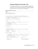
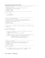
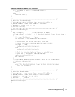
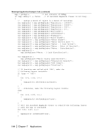
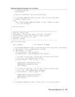
Municipal Application This Municipal Application demonstrates how you can monitor the water and sewer systems of a city. In the event of water distribution system problems, the application can notify the user, or a user can add an incident to the map and generate reports. The application uses color digital imagery to help orient the user. At the left of the window, the standard legend allows you to turn layers on and off and select them. At the right of the window the application includes Incident Monitor, where users are notified if there are problems with the water distribution system, and Layer Control, which allows you to turn off the incident layer, turn off all vector layers at the same time, and turn off the raster layer. These controls are useful for finding information quickly. Lastly, under Incident Entry and Reporting, the digitize incident and reporter buttons allow the user to add an incident to the map and generate reports about selected features. Municipal application 140 | Chapter 7 Applications
-
 1
1 -
2
-
3
-
4
-
5
-
6
-
7
-
8
-
9
-
10
-
11
-
12
-
13
-
14
-
15
-
16
-
17
-
18
-
19
-
20
-
21
-
22
-
23
-
24
-
25
-
26
-
27
-
28
-
29
-
30
-
31
-
32
-
33
-
34
-
35
-
36
-
37
-
38
-
39
-
40
-
41
-
42
-
43
-
44
-
45
-
46
-
47
-
48
-
49
-
50
-
51
-
52
-
53
-
54
-
55
-
56
-
57
-
58
-
59
-
60
-
61
-
62
-
63
-
64
-
65
-
66
-
67
-
68
-
69
-
70
-
71
-
72
-
73
-
74
-
75
-
76
-
77
-
78
-
79
-
80
-
81
-
82
-
83
-
84
-
85
-
86
-
87
-
88
-
89
-
90
-
91
-
92
-
93
-
94
-
95
-
96
-
97
-
98
-
99
-
100
-
101
-
102
-
103
-
104
-
105
-
106
-
107
-
108
-
109
-
110
-
111
-
112
-
113
-
114
-
115
-
116
-
117
-
118
-
119
-
120
-
121
-
122
-
123
-
124
-
125
-
126
-
127
-
128
-
129
-
130
-
131
-
132
-
133
-
134
-
 135
135 -
 136
136 -
 137
137 -
 138
138 -
 139
139 -
 140
140 -
 141
141 -
 142
142 -
 143
143 -
 144
144 -
 145
145 -
146
-
147
-
148
-
149
-
150
-
151
-
152
-
153
-
154
-
155
-
156
-
157
-
158
-
159
-
160
-
161
-
162
-
163
-
164
-
165
-
166
-
167
-
168
-
169
-
170
-
171
-
172
-
173
-
174
-
175
-
176
-
177
-
178
-
179
-
180
-
181
-
182
-
183
-
184
-
185
-
186
-
187
-
188
-
189
-
190
-
191
-
192
-
193
-
194
-
195
-
196
-
197
-
198
-
199
-
200
-
201
-
202
-
203
-
204
-
205
-
206
-
207
-
208
 |
 |
