Garmin GPSMAP 496 Owner's Manual (for North America) - Page 155
TIS(Traffic Information Service), TIS
 |
View all Garmin GPSMAP 496 manuals
Add to My Manuals
Save this manual to your list of manuals |
Page 155 highlights
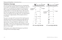
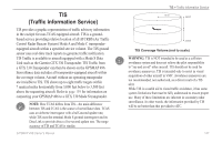
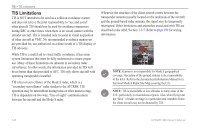
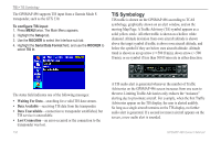
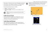
TIS > Traffic Information Service TIS (Traffic Information Service) 7.0 nm 3,500 ft TIS provides a graphic representation of traffic advisory information in the cockpit for non-TCAS equipped aircraft. TIS is a groundbased service providing relative location of all ATCRBS (Air Traffic Control Radar Beacon System) Mode A and Mode C transponderequipped aircraft within a specified service volume. The TIS ground sensor uses real-time track reports to generate traffic notification. TIS Traffic is available to aircraft equipped with a Mode S Data Link such as the Garmin GTX 330 Transponder. TIS Traffic from a GTX 330 Transponder can then be shown on the GPSMAP 496. Surveillance data includes all transponder-equipped aircraft within the coverage volume. Aircraft without an operating transponder are invisible to TIS. TIS shows up to eight traffic targets within 7 nautical miles horizontally from 3,000 feet below to 3,500 feet above the requesting aircraft. Refer to page 159 for information on connecting your GPSMAP 496 to a GTX 330 Mode S transponder. Note: How TCAS differs from TIS-the main difference between TIS and TCAS is the source of surveillance data. TCAS uses an airborne interrogator with a half-second update rate, while TIS uses the terminal Mode S ground interrogator and its Data Link to provide about a five-second update rate. The range accuracy of TIS and TCAS is similar. 3,000 ft TIS Coverage Volume (not to scale) Warning: TIS is NOT intended to be used as a collision avoidance system and does not relieve the pilot responsibility to "see and avoid" other aircraft. TIS should not be used for avoidance maneuvers. TIS is intended only to assist in visual acquisition of other aircraft in VMC. Avoidance maneuvers are not recommended, nor authorized, as a direct result of a TIS alert. While TIS is a useful aid to visual traffic avoidance, it has some system limitations that must be fully understood to ensure proper use. Many of these limitations are inherent in secondary radar surveillance. In other words, the information provided by TIS will be no better than that provided to ATC. GPSMAP 496 Owner's Manual 147
-
 1
1 -
2
-
3
-
4
-
5
-
6
-
7
-
8
-
9
-
10
-
11
-
12
-
13
-
14
-
15
-
16
-
17
-
18
-
19
-
20
-
21
-
22
-
23
-
24
-
25
-
26
-
27
-
28
-
29
-
30
-
31
-
32
-
33
-
34
-
35
-
36
-
37
-
38
-
39
-
40
-
41
-
42
-
43
-
44
-
45
-
46
-
47
-
48
-
49
-
50
-
51
-
52
-
53
-
54
-
55
-
56
-
57
-
58
-
59
-
60
-
61
-
62
-
63
-
64
-
65
-
66
-
67
-
68
-
69
-
70
-
71
-
72
-
73
-
74
-
75
-
76
-
77
-
78
-
79
-
80
-
81
-
82
-
83
-
84
-
85
-
86
-
87
-
88
-
89
-
90
-
91
-
92
-
93
-
94
-
95
-
96
-
97
-
98
-
99
-
100
-
101
-
102
-
103
-
104
-
105
-
106
-
107
-
108
-
109
-
110
-
111
-
112
-
113
-
114
-
115
-
116
-
117
-
118
-
119
-
120
-
121
-
122
-
123
-
124
-
125
-
126
-
127
-
128
-
129
-
130
-
131
-
132
-
133
-
134
-
135
-
136
-
137
-
138
-
139
-
140
-
141
-
142
-
143
-
144
-
145
-
146
-
147
-
148
-
149
-
 150
150 -
 151
151 -
 152
152 -
 153
153 -
 154
154 -
 155
155 -
 156
156 -
 157
157 -
 158
158 -
 159
159 -
 160
160 -
161
-
162
-
163
-
164
-
165
-
166
-
167
-
168
-
169
-
170
-
171
-
172
-
173
-
174
-
175
-
176
-
177
-
178
-
179
-
180
-
181
-
182
-
183
-
184
-
185
-
186
-
187
-
188
-
189
-
190
-
191
-
192
-
193
-
194
 |
 |
