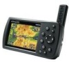
Garmin GPSMAP 496 Owner's Manual (for North America) - Page 189
Index - 76
 |
View all Garmin GPSMAP 496 manuals
Add to My Manuals
Save this manual to your list of manuals |
Page 189 highlights
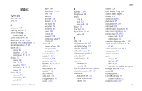
Index Index Symbols 2D 5, 63, 143 3D 5, 63 A accessories 157 acquiring satellites 5 Active Route page aviation mode 44 Active Track tab 87, 90 add to route 61, 68, 76, 80 advanced NMEA output setup 124 aircraft information 47-48 airport 18, 170 criteria 22 identifier 6, 12, 14 information 15, 16, 19 airspace 32 alarms 106 alert 21, 28 boundary 29, 32 information 20, 21, 32 nearest 18 alarms 28, 115 airspace 106 anchor drag 107 arrival 107 depth 108 descent rate 37, 38 DSC 100 fish 108 next turn 106 obstacle 37, 38 off course 107 persistent 106 proximity 86 sonar 108 system 107 terrain 37, 38 terrain page setup 39 VNAV 42 Alarms tab airspace alarms 106 navigation 106 system alarms 107 alerts. See alarms altitude 40, 119 antenna 1, 3, 162 append to route 80 approach 16, 23, 24, 44 ARTCC 18 assign category 83 asterisk (*) 16 audio connector 1 AutoLocate 3, 5 average location 80 avoids 67, 117 B backlight 3, 114 baro pressure 50 battery level 4 pack 1, 2 saver mode 116 beeper 115 BlueChart 160 bug indicator 41, 94 setting 34 C cable 158 calculate routes for 117 calculation method 117 calendar 109-112 calibrated airspeed 50 calibrate water speed 141 cards, data 160 care information 157 categories find menu 58 waypoint 82 CDI. See course deviation indicator celestial information 109-112 Celestial tab Hunt & Fish tab 112 Sun & Moon tab 109 Tide tab 110 charging 2, 4 check beacon wiring 164 cigarette lighter adapter 2 cleaning 156 clear track log 88 clock alarm 107 coast guard 168, 169 color mode 114 communication frequencies 20 comm usage restrictions 16 compass page 55, 95, 114 marine mode 94-95 options menu 94 connecting the power cable 2, 158 course deviation indicator 24, 40, 41, 94 course deviation scale 40, 41 course pointer 94 course to steer 34 create category 82 flight plan 27 route 61, 62 waypoint. See marking a waypoint creating a direct to 14-16 criteria 22 cruising speed 47 Current Route page 66 automotive mode 72 custom avoids 67, 117 GPSMAP 496 Owner's Manual 181
-
 1
1 -
2
-
3
-
4
-
5
-
6
-
7
-
8
-
9
-
10
-
11
-
12
-
13
-
14
-
15
-
16
-
17
-
18
-
19
-
20
-
21
-
22
-
23
-
24
-
25
-
26
-
27
-
28
-
29
-
30
-
31
-
32
-
33
-
34
-
35
-
36
-
37
-
38
-
39
-
40
-
41
-
42
-
43
-
44
-
45
-
46
-
47
-
48
-
49
-
50
-
51
-
52
-
53
-
54
-
55
-
56
-
57
-
58
-
59
-
60
-
61
-
62
-
63
-
64
-
65
-
66
-
67
-
68
-
69
-
70
-
71
-
72
-
73
-
74
-
75
-
76
-
77
-
78
-
79
-
80
-
81
-
82
-
83
-
84
-
85
-
86
-
87
-
88
-
89
-
90
-
91
-
92
-
93
-
94
-
95
-
96
-
97
-
98
-
99
-
100
-
101
-
102
-
103
-
104
-
105
-
106
-
107
-
108
-
109
-
110
-
111
-
112
-
113
-
114
-
115
-
116
-
117
-
118
-
119
-
120
-
121
-
122
-
123
-
124
-
125
-
126
-
127
-
128
-
129
-
130
-
131
-
132
-
133
-
134
-
135
-
136
-
137
-
138
-
139
-
140
-
141
-
142
-
143
-
144
-
145
-
146
-
147
-
148
-
149
-
150
-
151
-
152
-
153
-
154
-
155
-
156
-
157
-
158
-
159
-
160
-
161
-
162
-
163
-
164
-
165
-
166
-
167
-
168
-
169
-
170
-
171
-
172
-
173
-
174
-
175
-
176
-
177
-
178
-
179
-
180
-
181
-
182
-
183
-
 184
184 -
 185
185 -
 186
186 -
 187
187 -
 188
188 -
 189
189 -
 190
190 -
 191
191 -
 192
192 -
 193
193 -
 194
194
 |
 |
