Garmin eTrex Vista Owner's Manual - Page 24
Setup Options - mapsource
 |
UPC - 753759028329
View all Garmin eTrex Vista manuals
Add to My Manuals
Save this manual to your list of manuals |
Page 24 highlights
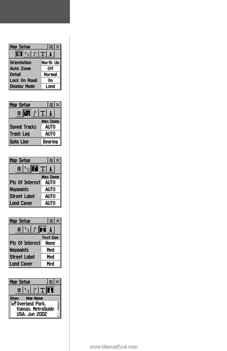
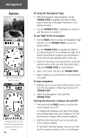
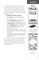
Map Setup Options Page Setup Tracks Setup Map Features Setup Text Setup Map Data 14 The 'Setup Map' option displays the five Map Setup Pages, each accessed by an on-screen button. A list of options displays for the features listed. Scale options indicate the point at which Tracks, Tracks Logs, Map Features, or Text Boxes display, allowing you to remove map clutter and define map features. Page - Orientation: 'Track Up' or 'North Up'; fixes the top of the map display to the current track heading or to a north heading. Auto Zoom: On or Off; automatically scales the map to display both your current location and the next point to which you are navigating. Detail: Most, More, Normal, Less, or Least; controls how much map detail you see. This setting only applies to a map feature set to 'Auto'. Those features which have a specified scale or are turned 'Off' are unaffected by this setting. Lock on Road: On or Off; available only if MapSource Data is loaded; when 'On' the triangle icon locks to the road that you are traveling. Display Mode: Land or Water; choice displays in light color while the other displays in a dark color. Tracks - Saved Tracks and Track Log: Scale options; 'Off', 'Auto', or 20 ft.-500 miles, sets the maximum scale at which the feature should appear on the screen. Some types of data will display only to certain zoom scales. Goto Line: Bearing or Course; determines which pointer displays. Map Features - Points of Interest, Waypoints, Street Label, and Land Cover, Scale options; 'Off', 'Auto', or 20 ft.-500 miles, sets the maximum scale at which the feature should appear on the screen. Some types of data will display only to certain zoom scales. Text - Points of Interest, Waypoints, Street Label, and Land Cover, Text sizes; 'None', 'Small', 'Medium', or 'Large'control the screen size of the name. MapSource Info - Show, Check box; check mark determines if map data is used or not.
-
 1
1 -
2
-
3
-
4
-
5
-
6
-
7
-
8
-
9
-
10
-
11
-
12
-
13
-
14
-
15
-
16
-
17
-
18
-
 19
19 -
 20
20 -
 21
21 -
 22
22 -
 23
23 -
 24
24 -
 25
25 -
 26
26 -
 27
27 -
 28
28 -
 29
29 -
30
-
31
-
32
-
33
-
34
-
35
-
36
-
37
-
38
-
39
-
40
-
41
-
42
-
43
-
44
-
45
-
46
-
47
-
48
-
49
-
50
-
51
-
52
-
53
-
54
-
55
-
56
-
57
-
58
-
59
-
60
-
61
-
62
-
63
-
64
-
65
-
66
-
67
-
68
-
69
-
70
-
71
-
72
-
73
-
74
-
75
-
76
-
77
-
78
-
79
-
80
-
81
-
82
-
83
-
84
 |
 |