Garmin eTrex Vista Owner's Manual - Page 71
Data Field, Definitions
 |
UPC - 753759028329
View all Garmin eTrex Vista manuals
Add to My Manuals
Save this manual to your list of manuals |
Page 71 highlights
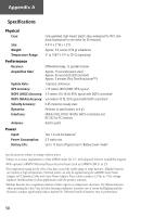
Appendix C Data Field Definitions To Course - The compass direction you must go in order to get back to the original course. Trip Odometer - A running tally of distance travelled since last reset. Turn - The angle difference (in degrees) between the bearing to your destination and your current line of travel. 'L' means turn Left. 'R' means turn Right. Velocity Made Good - The speed at which you are closing on a destination along a desired course. Vertical Speed - Your rate of altitude gain/loss over time. Vertical Speed Destination - The speed at which you are descending to your desti- nation altitude. Altimeter Page These options are available only on the Altimeter Page. Other options available are defined beginning on page 60. Ambient Pressure - The uncalibrated current pressure. Average Ascent - The avg. vertical distance of ascents. Average Descent - The avg. vertical distance of descents. Barometer Pressure - The calibrated current pressure. Elevation - The altitude above sea level. Maximum Ascent - The maximum ascent rate in feet per minute. Maxium Descent - The maximum descent rate in feet per minute. Maximum Elevation - The highest elevation reached. Minimum Elevation - The lowest elevation reached. Total Ascent - The total distance ascended. Total Descent - The total distance descended. 61
-
 1
1 -
2
-
3
-
4
-
5
-
6
-
7
-
8
-
9
-
10
-
11
-
12
-
13
-
14
-
15
-
16
-
17
-
18
-
19
-
20
-
21
-
22
-
23
-
24
-
25
-
26
-
27
-
28
-
29
-
30
-
31
-
32
-
33
-
34
-
35
-
36
-
37
-
38
-
39
-
40
-
41
-
42
-
43
-
44
-
45
-
46
-
47
-
48
-
49
-
50
-
51
-
52
-
53
-
54
-
55
-
56
-
57
-
58
-
59
-
60
-
61
-
62
-
63
-
64
-
65
-
 66
66 -
 67
67 -
 68
68 -
 69
69 -
 70
70 -
 71
71 -
 72
72 -
 73
73 -
 74
74 -
 75
75 -
 76
76 -
77
-
78
-
79
-
80
-
81
-
82
-
83
-
84
 |
 |
