Garmin eTrex Vista Owner's Manual - Page 34
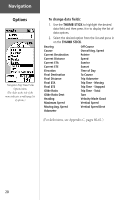
Altimeter Options Menu.
 |
UPC - 753759028329
View all Garmin eTrex Vista manuals
Add to My Manuals
Save this manual to your list of manuals |
Page 34 highlights
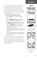
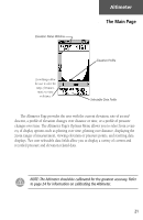
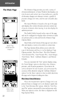
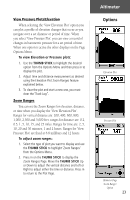
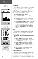
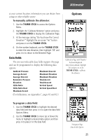
Altimeter Options Altimeter Page 'View Points' Option Reset Options Menu Useful for clearing old data. IMPORTANT! Use care when selecting DELETE options as this removes all saved Tracks, Waypoints, and Routes from the unit memory. 24 View Points The 'View Points' option allows you to scroll through the stored elevation profile and to view a single point along the profile. When the pointer is stopped at a location along the profile, the display shows the elevation, time of day and date the point was created. To use the 'View Points' option: 1. Use the THUMB STICK to access the Options Menu. 2. Highlight the 'View Points' option and press in on the THUMB STICK to display the View Points Page. 3. Move the THUMB STICK Right or Left to scroll the profile past the pointer in the center of the page. As the profile moves past the pointer, the status window at the top of page changes to display the date, time, and altitude for the point beneath the pointer. Reset You can reset the elevation data and the maximum elevation data by selecting the 'Reset' option from the Altimeter Page Options Menu. To reset the elevation data and max elevation fields: 1. Use the THUMB STICK to highlight the 'Reset' option from the page Options Menu and press in on the THUMB STICK to display the 'Reset' page. 2. Use the THUMB STICK to highlight the reset options on the page and then press in on the THUMB STICK to place a check mark in the box next to a selected item. 3. Move to the 'Apply' button and press in on the THUMB STICK to reset the data fields. Calibrate Altimeter Because the eTrex Vista relies on the Barometric pressure to determine the elevation and the pressure at any given elevation can fluctuate, you can calibrate the altimeter to increase its accuracy. You must know the elevation
-
 1
1 -
2
-
3
-
4
-
5
-
6
-
7
-
8
-
9
-
10
-
11
-
12
-
13
-
14
-
15
-
16
-
17
-
18
-
19
-
20
-
21
-
22
-
23
-
24
-
25
-
26
-
27
-
28
-
 29
29 -
 30
30 -
 31
31 -
 32
32 -
 33
33 -
 34
34 -
 35
35 -
 36
36 -
 37
37 -
 38
38 -
 39
39 -
40
-
41
-
42
-
43
-
44
-
45
-
46
-
47
-
48
-
49
-
50
-
51
-
52
-
53
-
54
-
55
-
56
-
57
-
58
-
59
-
60
-
61
-
62
-
63
-
64
-
65
-
66
-
67
-
68
-
69
-
70
-
71
-
72
-
73
-
74
-
75
-
76
-
77
-
78
-
79
-
80
-
81
-
82
-
83
-
84
 |
 |
