Lowrance HDS-7 Gen2 Touch Operation Manual - Page 21
Chart - insight
 |
View all Lowrance HDS-7 Gen2 Touch manuals
Add to My Manuals
Save this manual to your list of manuals |
Page 21 highlights
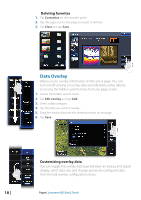
4 Chart The chart page displays your position relative to land and other chart objects. On the page you can plan and navigate routes, place waypoints, overlay a radar image, a StructureMap image and weather information, and display AIS targets. ¼¼ Note: This unit has different embedded cartography depending on the region. The first part of this section describes how to use the charts, and is common to both Insight and Navionics. Chart options depend on which cartography is in use on the unit. The Chart page * Optional chart items Extension line * Vessel Grid lines * Opens page menu Waypoint * Cursor Range rings * Trail* Zoom keys Chart range scale ¼¼ Note: You turn the optional images on/off individually. Refer to Chart settings later in this section. Vessel symbol When a GPS and a suitable heading sensor are connected to the system, the vessel symbol indicates vessel position and heading. Without a heading sensor installed, the icon will position itself using COG (Course over Ground). If no GPS is available the vessel symbol will include a question mark. Chart | Lowrance HDS Gen2 Touch | 19
-
 1
1 -
2
-
3
-
4
-
5
-
6
-
7
-
8
-
9
-
10
-
11
-
12
-
13
-
14
-
15
-
 16
16 -
 17
17 -
 18
18 -
 19
19 -
 20
20 -
 21
21 -
 22
22 -
 23
23 -
 24
24 -
 25
25 -
 26
26 -
27
-
28
-
29
-
30
-
31
-
32
-
33
-
34
-
35
-
36
-
37
-
38
-
39
-
40
-
41
-
42
-
43
-
44
-
45
-
46
-
47
-
48
-
49
-
50
-
51
-
52
-
53
-
54
-
55
-
56
-
57
-
58
-
59
-
60
-
61
-
62
-
63
-
64
-
65
-
66
-
67
-
68
-
69
-
70
-
71
-
72
-
73
-
74
-
75
-
76
-
77
-
78
-
79
-
80
-
81
-
82
-
83
-
84
-
85
-
86
-
87
-
88
-
89
-
90
-
91
-
92
-
93
-
94
-
95
-
96
-
97
-
98
-
99
-
100
-
101
-
102
-
103
-
104
-
105
-
106
-
107
-
108
-
109
-
110
-
111
-
112
-
113
-
114
-
115
-
116
-
117
-
118
-
119
-
120
-
121
-
122
-
123
-
124
-
125
-
126
-
127
-
128
-
129
-
130
-
131
-
132
-
133
-
134
-
135
-
136
-
137
 |
 |
