Lowrance HDS-7 Gen2 Touch Operation Manual - Page 33
Navionics settings
 |
View all Lowrance HDS-7 Gen2 Touch manuals
Add to My Manuals
Save this manual to your list of manuals |
Page 33 highlights
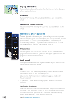
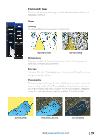
Navionics settings Optional settings for Navionics charts Traditional 2D chart Chart with shading Colored Seabed Areas Colors different parts of the seabed to provide better definition of seabed composition. Annotation Determines what area information, such as names of locations and notes of areas, is available on display. Presentation type Provides marine charting information such as symbols, colors of the navigation chart and wording for either International or US presentation types. Chart details Provides you with different levels of geographical layer information. Safety depth The Navionics charts uses different shades of blue to distinguish between shallow and deep water. The safety depth sets the limit for which depths that shall be drawn without blue shading. Contours depth Determines which contours you see on the chart down to the selected safety depth value. Rock filtering Filters rocks below a certain depth Chart | Lowrance HDS Gen2 Touch | 31
-
 1
1 -
2
-
3
-
4
-
5
-
6
-
7
-
8
-
9
-
10
-
11
-
12
-
13
-
14
-
15
-
16
-
17
-
18
-
19
-
20
-
21
-
22
-
23
-
24
-
25
-
26
-
27
-
 28
28 -
 29
29 -
 30
30 -
 31
31 -
 32
32 -
 33
33 -
 34
34 -
 35
35 -
 36
36 -
 37
37 -
 38
38 -
39
-
40
-
41
-
42
-
43
-
44
-
45
-
46
-
47
-
48
-
49
-
50
-
51
-
52
-
53
-
54
-
55
-
56
-
57
-
58
-
59
-
60
-
61
-
62
-
63
-
64
-
65
-
66
-
67
-
68
-
69
-
70
-
71
-
72
-
73
-
74
-
75
-
76
-
77
-
78
-
79
-
80
-
81
-
82
-
83
-
84
-
85
-
86
-
87
-
88
-
89
-
90
-
91
-
92
-
93
-
94
-
95
-
96
-
97
-
98
-
99
-
100
-
101
-
102
-
103
-
104
-
105
-
106
-
107
-
108
-
109
-
110
-
111
-
112
-
113
-
114
-
115
-
116
-
117
-
118
-
119
-
120
-
121
-
122
-
123
-
124
-
125
-
126
-
127
-
128
-
129
-
130
-
131
-
132
-
133
-
134
-
135
-
136
-
137
 |
 |
