Magellan Maestro 3100 Manual - English - Page 15
Magellan CrossoverGPS Vehicle Navigation Screens - map
 |
UPC - 763357117226
View all Magellan Maestro 3100 manuals
Add to My Manuals
Save this manual to your list of manuals |
Page 15 highlights
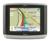
Magellan CrossoverGPS Vehicle Navigation Screens Map Screen The Map Screen is the most commonly used screen on the Magellan CrossoverGPS. Whether you are getting directions or just driving around town, the Map screen will give you the peace of mind of knowing where you are. 1 13 2 12 3 11 4 5 10 6 9 7 8 This map shows the vehicle travelling on 1st Ave. with a left turn on Cedar St. coming up in 0.2 miles. At the posted speed limit, the turn will occur in 1 minute. 1 Current Street Name Zoom out 2 3 Destination Icon 4 POI Icon 5 Location Icon Next Maneuver 6 Distance to Next 7 Maneuver Name of street you are currently on. When tapped, displays the Locate screen When tapped, zooms out the map display. Provides a visual indication of your destination. Sample indicated is the icon When tapped, offers you the option for a restaurant. of setting a trip to that POI. Provides visual indication of your current position. Indicates what type of maneuver you will need to perform when directed. Displays the computed distance to your next maneuver in the unit of measure chosen. When tapped displays your heading as N, NE, NW, W, etc. When tapped repeats the last verbal instruction. Magellan Crossover Vehicle Navigation Screens 6
-
 1
1 -
2
-
3
-
4
-
5
-
6
-
7
-
8
-
9
-
 10
10 -
 11
11 -
 12
12 -
 13
13 -
 14
14 -
 15
15 -
 16
16 -
 17
17 -
 18
18 -
 19
19 -
 20
20 -
21
-
22
-
23
-
24
-
25
-
26
-
27
-
28
-
29
-
30
-
31
-
32
-
33
-
34
-
35
-
36
-
37
-
38
-
39
-
40
-
41
-
42
-
43
-
44
-
45
-
46
-
47
-
48
-
49
-
50
-
51
-
52
-
53
-
54
-
55
-
56
-
57
-
58
-
59
-
60
-
61
-
62
-
63
-
64
-
65
-
66
-
67
-
68
-
69
 |
 |
