Garmin G600 Pilots Guide - Page 172
Surface Data Viewing Range
 |
View all Garmin G600 manuals
Add to My Manuals
Save this manual to your list of manuals |
Page 172 highlights
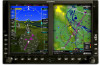
Foreword System Sec 1 PFD Sec 2 A Stationary Front is a front with very little horizontal movement. The line alternates with orange and blue sections which point in opposite directions to symbolize little movement. Figure 4-33 XM Weather - Stationary Front An Occluded Front is where a cold front has overtaken and merged with a warm front. The line alternates with the blue triangle and orange half moon symbols on the same side of the line pointing in the direction the front is moving. Figure 4-34 XM Weather - Occluded Front Surface Data Viewing Range The Surface Data Viewing Range option allows you to select the map range where below that value Surface Data weather products will be shown on the selected MFD Wx Data Link Map page (1, 2, or 3). When Off is selected, Surface Data will not be shown. MFD Sec 3 Features Avoidance Hazard Sec 4 Additional Sec 5 & Alerts Annun. Sec 6 Symbols Sec 7 Appendix A Glossary Sec 8 Index Appendix B Figure 4-35 Surface data Viewing Range Selection 1) While viewing a WX Data Link Map page of the WX page group, press the MENU key to display the Page Menu Options. The cursor flashes on the "Weather Setup" option. Press ENT. 4-46 Garmin G600 Pilot's Guide 190-00601-02 Rev. B
-
 1
1 -
2
-
3
-
4
-
5
-
6
-
7
-
8
-
9
-
10
-
11
-
12
-
13
-
14
-
15
-
16
-
17
-
18
-
19
-
20
-
21
-
22
-
23
-
24
-
25
-
26
-
27
-
28
-
29
-
30
-
31
-
32
-
33
-
34
-
35
-
36
-
37
-
38
-
39
-
40
-
41
-
42
-
43
-
44
-
45
-
46
-
47
-
48
-
49
-
50
-
51
-
52
-
53
-
54
-
55
-
56
-
57
-
58
-
59
-
60
-
61
-
62
-
63
-
64
-
65
-
66
-
67
-
68
-
69
-
70
-
71
-
72
-
73
-
74
-
75
-
76
-
77
-
78
-
79
-
80
-
81
-
82
-
83
-
84
-
85
-
86
-
87
-
88
-
89
-
90
-
91
-
92
-
93
-
94
-
95
-
96
-
97
-
98
-
99
-
100
-
101
-
102
-
103
-
104
-
105
-
106
-
107
-
108
-
109
-
110
-
111
-
112
-
113
-
114
-
115
-
116
-
117
-
118
-
119
-
120
-
121
-
122
-
123
-
124
-
125
-
126
-
127
-
128
-
129
-
130
-
131
-
132
-
133
-
134
-
135
-
136
-
137
-
138
-
139
-
140
-
141
-
142
-
143
-
144
-
145
-
146
-
147
-
148
-
149
-
150
-
151
-
152
-
153
-
154
-
155
-
156
-
157
-
158
-
159
-
160
-
161
-
162
-
163
-
164
-
165
-
166
-
 167
167 -
 168
168 -
 169
169 -
 170
170 -
 171
171 -
 172
172 -
 173
173 -
 174
174 -
 175
175 -
 176
176 -
 177
177 -
178
-
179
-
180
-
181
-
182
-
183
-
184
-
185
-
186
-
187
-
188
-
189
-
190
-
191
-
192
-
193
-
194
-
195
-
196
-
197
-
198
-
199
-
200
-
201
-
202
-
203
-
204
-
205
-
206
-
207
-
208
-
209
-
210
-
211
-
212
-
213
-
214
-
215
-
216
-
217
-
218
-
219
-
220
-
221
-
222
-
223
-
224
-
225
-
226
-
227
-
228
-
229
-
230
-
231
-
232
-
233
-
234
-
235
-
236
-
237
-
238
-
239
-
240
 |
 |
