Garmin G600 Pilots Guide - Page 194
Using SafeTaxi, SafeTaxi Cycle Number and Revision
 |
View all Garmin G600 manuals
Add to My Manuals
Save this manual to your list of manuals |
Page 194 highlights
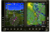
Foreword System Sec 1 PFD Sec 2 MFD Sec 3 Features Avoidance Hazard Sec 4 5.4.1 Using SafeTaxi Any map page that displays the navigation view can also show the SafeTaxi airport layout within the maximum configured range. The following is a list of pages where the SafeTaxi feature can be seen: • Navigation Map Page • NDB Information Page • Weather Datalink Page • VOR Information Page • Airport Information Page • User Waypoint Information Page • Intersection Information Page During ground operations the aircraft's position is displayed in reference to taxiways, runways, and airport features. When panning over the airport, features such as runway holding lines and taxiways are shown. The DCLTR soft key (declutter) label advances to DCLTR-1, DCLTR -2, and DCLTR-3 each time the soft key is selected for easy recognition of decluttering level. Selecting the DCLTR soft key removes the taxiway markings and airport feature labels. Selecting the DCLTR-1 soft key removes VOR station ID, the VOR symbol, and intersection names if within the airport plan view. Selecting the DCLTR-2 soft key removes the airport runway layout, unless the airport in view is part of an active route structure. Pressing the DCLTR-3 soft key cycles back to the original map detail. Refer to Map Declutter Levels in the Navigation Map Section. 5.4.2 SafeTaxi Cycle Number and Revision The SafeTaxi database is revised every 56 days. SafeTaxi is always available for use after the expiration date. When turning on the GDU 620, the Power-up Page indicates whether the databases are current, out of date, or not available. The Power-up Page shows the SafeTaxi database is current when the "SafeTaxi Expires" date is shown in white. When the SafeTaxi cycle has expired, the "SafeTaxi Expires" date appears in yellow. The message "SafeTaxi: N/A" appears in white if no SafeTaxi data is available on the database card. Additional Sec 5 & Alerts Annun. Sec 6 Symbols Sec 7 Appendix A Glossary Sec 8 Index Appendix B 5-14 Garmin G600 Pilot's Guide 190-00601-02 Rev. B
-
 1
1 -
2
-
3
-
4
-
5
-
6
-
7
-
8
-
9
-
10
-
11
-
12
-
13
-
14
-
15
-
16
-
17
-
18
-
19
-
20
-
21
-
22
-
23
-
24
-
25
-
26
-
27
-
28
-
29
-
30
-
31
-
32
-
33
-
34
-
35
-
36
-
37
-
38
-
39
-
40
-
41
-
42
-
43
-
44
-
45
-
46
-
47
-
48
-
49
-
50
-
51
-
52
-
53
-
54
-
55
-
56
-
57
-
58
-
59
-
60
-
61
-
62
-
63
-
64
-
65
-
66
-
67
-
68
-
69
-
70
-
71
-
72
-
73
-
74
-
75
-
76
-
77
-
78
-
79
-
80
-
81
-
82
-
83
-
84
-
85
-
86
-
87
-
88
-
89
-
90
-
91
-
92
-
93
-
94
-
95
-
96
-
97
-
98
-
99
-
100
-
101
-
102
-
103
-
104
-
105
-
106
-
107
-
108
-
109
-
110
-
111
-
112
-
113
-
114
-
115
-
116
-
117
-
118
-
119
-
120
-
121
-
122
-
123
-
124
-
125
-
126
-
127
-
128
-
129
-
130
-
131
-
132
-
133
-
134
-
135
-
136
-
137
-
138
-
139
-
140
-
141
-
142
-
143
-
144
-
145
-
146
-
147
-
148
-
149
-
150
-
151
-
152
-
153
-
154
-
155
-
156
-
157
-
158
-
159
-
160
-
161
-
162
-
163
-
164
-
165
-
166
-
167
-
168
-
169
-
170
-
171
-
172
-
173
-
174
-
175
-
176
-
177
-
178
-
179
-
180
-
181
-
182
-
183
-
184
-
185
-
186
-
187
-
188
-
 189
189 -
 190
190 -
 191
191 -
 192
192 -
 193
193 -
 194
194 -
 195
195 -
 196
196 -
 197
197 -
 198
198 -
 199
199 -
200
-
201
-
202
-
203
-
204
-
205
-
206
-
207
-
208
-
209
-
210
-
211
-
212
-
213
-
214
-
215
-
216
-
217
-
218
-
219
-
220
-
221
-
222
-
223
-
224
-
225
-
226
-
227
-
228
-
229
-
230
-
231
-
232
-
233
-
234
-
235
-
236
-
237
-
238
-
239
-
240
 |
 |
